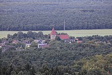
Rennberg (Haard)
| Rennberg | ||
|---|---|---|
| height | 138 m above sea level NHN | |
| location | near Flaesheim ; Recklinghausen district , North Rhine-Westphalia ( Germany ) |
|
| Mountains | Hair | |
| Coordinates | 51 ° 42 '2 " N , 7 ° 13' 14" E | |
|
|
||
| particularities | Location of the Rennberg fire watch tower (also lookout tower) | |


The Rennberg near Flaesheim in the North Rhine-Westphalian district of Recklinghausen is about 138 m above sea level. NHN, after the Stimberg ( 156.9 m ), is the second highest elevation of the Haard , a hilly landscape on the northern edge of the Ruhr area .
geography
location
The Rennberg lies in the northern part of the wooded Haard and in the east of the Hohe Mark-Westmünsterland Nature Park . Its summit region rises around 5 km (as the crow flies ) south-south-east of the town center of Haltern am See , to whose urban area - located on the Lippe and the Wesel-Datteln Canal - it belongs, and around 2 km south-south-west of the Haltern district of Flaesheim . Around 400 m south of the summit region lies the border between Haltern and the town of Oer-Erkenschwick , in whose area the southern foothills of the elevation extend.
Mountain height
The top elevation line recognizable on topographic maps in the summit region of the Rennberg around the fire watch tower points to a height of 138 m . However, the height of the elevation is often only given as about 136 m , which refers to a forest path point slightly north-northwest of the summit at 136.1 m height; but sometimes a height of 139 m is also mentioned. About 150 m north-north-west of the tower there is a point at 137.9 m and just under 300 m northwest of the tower one at 137.5 m - both as wooded hills. About 370 m south of the tower standing on the summit region and thus a little north of the Haltern border, beyond a 132 m high notch, there is a 136.8 m high point. From there the forest landscape leads south into the area of Oer-Erkenschwick.
Natural allocation and landscape protection
The Rennberg belongs in the natural spatial main unit group Westphalian Bight (No. 54) and in the main unit Westmünsterland (544) to the subunit Haard (544.7).
The survey is located in the landscape protection area south of Flaesheim ( CDDA no. 320987; designated 1990; 5.29 km² ), with the NSG area of the northern Haltern forest east and west of the B 51 (CDDA no. 320972; 1990 ; 8.21 km²).
Rennberg fire watch tower
A wooden fire watch tower and lookout tower used to stand on the summit region of the Rennberg . The dilapidated structure, which was 35 m high, was demolished in 2009 and replaced by the 35 m high Rennberg fire watch tower made of hot-dip galvanized steel construction. It was inaugurated on March 31, 2010. From its viewing platform, which can be reached via 143 steps and is located at a tower height of 32 m, at about 168 m above sea level. NHN the view falls over the Haard to Flaesheim, to the Flaesheim lock on the Wesel-Datteln Canal and, if visibility is good, to the Ruhr area and the Münsterland . The network operator Telefonica distributes the GSM, UMTS and LTE radio standards from the fire watch tower.
Traffic and walking
About 2 km north past the Rennberg leads east-southeast from Bossendorf through Flaesheim to Ahsen the state road 609, which crosses the L 612 at Flaesheim. Both streets crosses the L 551, which runs about 2 km west of the Rennberg and leads south from Bossendorf to Sinsen ( Marl ). For example, starting at these roads you can hike the elevation on forest paths and paths. The Herzogsweg leads over the Rennberg near the summit .
Individual evidence
- ↑ a b c Topographical Information Management, Cologne District Government, Department GEObasis NRW ( information )
- ^ Wilhelm von Kürten: Geographical land survey: The natural space units on sheet 95/96 Kleve / Wesel. Federal Institute for Regional Studies, Bad Godesberg 1977. → Online map (PDF; 6.9 MB)
- ↑ Map services of the Federal Agency for Nature Conservation ( information )
- ↑ a b c article New fire watch tower - marvelous view of the Haard , from March 31, 2010, on halternerzeitung.de
- ↑ Walter Neumann: The fire watch tower on the Rennberg in the Haard . In: Haltern Yearbook 2020 (Haltern 2019)

