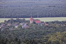
Flaesheim
|
Flaesheim
City of Haltern am See
|
||
|---|---|---|
| Coordinates: 51 ° 43 ′ 6 ″ N , 7 ° 13 ′ 46 ″ E | ||
| Height : | 45 m above sea level NN | |
| Area : | 13.33 km² | |
| Residents : | 1918 (Dec. 31, 2019) | |
| Population density : | 144 inhabitants / km² | |
| Incorporation : | 1st January 1975 | |
| Postal code : | 45721 | |
| Area code : | 02364 | |
|
Location of Flaesheim in North Rhine-Westphalia |
||
Flaesheim ( flaːshaim ) ( Low German : Flaosem) is a district of the town of Haltern am See in North Rhine-Westphalia with 1918 inhabitants (December 2019).
The surrounding area is characterized by the Haard forest in the south, the Wesel-Datteln Canal and the Lippe in the north; various agricultural areas are in the vicinity.
Due to the geographical location on the border between the Ruhr area and Münsterland , the regional allocation is controversial. Because Flaesheim is a part of Vest Recklinghausen , because of its historical affiliation to the Archdiocese of Cologne (today in the Diocese of Münster ) and its location south of the Lippe, it is historically part of the Ruhr area.
geography
Geographical location

The place is on the northern edge of the Ruhr area in the valley of the Lippe and north of the Haard.
Townscape
Flaesheim essentially consists of three settlement areas: in the west the Flaesheim-Dorf peasantry, in the center the main town Flaesheim (or Flaesheim-Stift based on the former Flaesheim monastery) and in the east the peasantry Westleven.
Due to the good connection to the A 43 and A 52 as well as a shortage of local jobs, Flaesheim has developed into a commuter village. On the other hand, many people from the Ruhr area in particular spend their free time here, be it on day trips to the nearby Haard or to relax for longer on one of the campsites.
Local life is managed by local clubs such as the SuS Concordia Flaesheim 1969 e. V. (whose women's football department merged in 1999 with the women's football department of Rot-Weiß Hillen to form the independent Bundesliga club FFC Flaesheim-Hillen ), the Bürgererschützenverein 1899/1952 e. V., the Heimatverein, the Flaesheim volunteer fire brigade and their marching band .
history
The first Germanic settlement and grave finds date from around 9 AD. In the period between 700 and 720 the Saxons were in the area of today's Flaesheim; this is evidenced by the discovery of pagan graves near the collegiate church.
In 1166, Count Otto I von Ravensberg founded the Flaesheim Monastery . The first nuns came from the Rhenish Knechtsteden and were according to the rule of St. Augustine called Premonstratensian women.
After Count Otto II von Ravensberg renounced the Flaesheim monastery, it became the property of the Archbishop of Cologne .
The abbess Maria von Ketteler donated a new high altar to the Flaesheim monastery , designed by the sculptor Gerhard Gröninger from Münster .
A school was first mentioned in 1717. At first it was a pure parish school, but in 1799 the construction of a school building began.
In 1803 the Flaesheim Monastery became the property of the Duke of Arenberg , who dissolved it in 1808.
Flaesheim has had its own volunteer fire brigade since October 17, 1920. The electricity came to Flaesheim in 1922, and on June 14, 1939 Flaesheim's coat of arms was established.
The municipality of Flaesheim has been part of the city of Haltern since January 1st, 1975.
Culture and sights
Collegiate Church of St. Mary Magdalene
The parish church of St. Maria Magdalena, built in the 14th century, is of Romanesque origin (partly Gothic-like ) and contains some important art treasures. Opposite is the St. Norberthaus, which serves as an event location and community center.
Events and festivals
A special, folk festival- like event is the annual construction of a charcoal pile in May on the Dachsberg in der Haard. There is also a shooting festival every three years .
Economy and Infrastructure
traffic
With the bus line 288, which is operated by the Vestische trams and runs from Datteln to Haltern, Flaesheim can be reached by local public transport .
Flaesheim is connected to the trunk road network by the A 43 Wuppertal –Münster motorway at the Marl-Nord motorway junction. The A 52 from Düsseldorf via Essen , whose feeder (L 612) leads to Flaesheim, also ends there .
The Wesel-Datteln Canal borders Flaesheim in the north. The Flaesheim lock is located near the collegiate church . Further east - in the connecting arm to a quarry pond - is the Flaesheim Marina .
Web links
- Flaesheim at GenWiki
- Flaesheim in the Westphalian Cultural Atlas
- Flaesheimer Heimatverein eV
Individual evidence
- ↑ Facts and Figures | City of Haltern am See. Retrieved March 16, 2020 .
- ↑ Wenkerbogen Flaesheim, Digital Wenker Atlas ( Memento of the original from January 23, 2016 in the Internet Archive ) Info: The archive link was inserted automatically and has not yet been checked. Please check the original and archive link according to the instructions and then remove this notice.
- ↑ Facts and Figures | City of Haltern am See. Retrieved March 16, 2019 .
- ^ Federal Statistical Office (ed.): Historical municipality directory for the Federal Republic of Germany. Name, border and key number changes in municipalities, counties and administrative districts from May 27, 1970 to December 31, 1982 . W. Kohlhammer, Stuttgart / Mainz 1983, ISBN 3-17-003263-1 , p. 316 .
swell
- History and stories of the Haltern district of Flaesheim , Heimatfreunde Haltern, 1999
- Contributions to the history of Flaesheim No. 3 , Heimatverein Flaesheim, 2001


