Stimberg
| Stimberg | ||
|---|---|---|
|
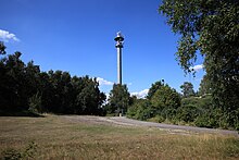
View from the Rennberg fire watch tower in southeastern direction past the Farnberg fire watch tower to the Stimberg with the transmission tower; to the right, the upper part of the cooling tower of the Datteln power plant ; Dates on the left at the edge of the picture |
||
| height | 156.9 m above sea level NHN | |
| location | at Oer-Erkenschwick ; Recklinghausen district , North Rhine-Westphalia ( Germany ) |
|
| Mountains | Hair | |
| Coordinates | 51 ° 39 '56 " N , 7 ° 15' 24" E | |
|
|
||
| rock | Silicified sandstone (quartzite) | |
| particularities | Location of a transmission tower | |
The Stimberg near Oer-Erkenschwick in the North Rhine-Westphalian district of Recklinghausen is 156.9 m above sea level. NHN the highest elevation of the Haard , a hilly landscape on the northern edge of the Ruhr area .
geography
location
The Stimberg lies in the southern part of the wooded Haard and in the east of the Hohe Mark-Westmünsterland Nature Park . It rises 1.8 km (as the crow flies ) north of the center of Oer , a district of Oer-Erkenschwick , to whose urban area the elevation belongs, and about 6 km west-north-west of that date . The north-north-western neighbor is Farnberg, 850 m away (as the crow flies) .
On the south-western slope of the Stimberg, the Silvertbach tributary Denningsgraben rises on the western edge of the Stimberg Park and the Lippe tributary Mahlenburger Mühlengraben to the east below its eastern branch Küsberg ( 133 m ) .
Natural allocation
The Stimberg belongs in the natural spatial main unit group Westfälische Bucht (No. 54) and in the main unit Westmünsterland (544) to the subunit Haard (544.7), with its landscape in the neighboring main unit Emscherland (543) to the east and southeast into the subunit Bockumer Hügelwellen ( 543.12) and drops to the southwest into the subunit Oer-Sinsener Flachwellen (543.13).
Mountain height
The height of the 156.9 m high Stimberg is sometimes only given as 153 or 154 m , but this refers to an altitude of 153.8 m , which can be seen on topographic maps about 50 m northeast of the summit . About 90 m north of this point there is a trigonometric point at 141.4 m and in this area on another map one at 151.5 m height.
Protected areas
The Stimberg is located in the protected landscape area north of Oer-Erkenschwick ( CDDA -No 320,981;. Reported in 1990, 6.89 square kilometers in size). To the east of its summit is the Stimberghöhe nature reserve (CDDA No. 165740; designated in 1990; 1 hectare in size).
geology
Around 80 million years ago there was a shallow sea at this point. The climate was significantly warmer than today. From the mainland to the south (today's Sauerland ), large amounts of sand were transported across the rivers and deposited in the sea. Over long periods of time, up to 300 m thick layers of sand, the so-called Haltern Sands (scientific name: Haltern Formation), were created.
Later uplifts brought the former sea floor back to the surface. The formerly overlying layers and large parts of the Haltern Sands were removed again by erosion . The Stimberg withstood the weathering processes much better than the surrounding area. The cause are the silicified sandstones ( quartzite ).
The otherwise loose Haltern sands are solidified here by silica precipitated from the groundwater and form resistant solid rock. The irregular, bulbous structure is based on the uneven precipitation of the silica between the grains of sand.
history
Since the quartzite was the only usable solid rock in the wide area, quarries have been operated on Stimberg (formerly Steynberg = Steinberg) since the Middle Ages . The Stimberg quartzite is found as a work stone in many old buildings in the area (e.g. the city wall of Recklinghausen ). In 1890, the Stimberg was a triangular point of the first order of the Prussian land registry .
Radar station
About 60 m northwest and a few meters below the Stimberg summit were a radar station of the Bundeswehr and a transmission tower . The site has belonged to the development company of the city of Oer-Erkenschwick since 2006, and the Federal Network Agency operates the tower.
Traffic and walking
Southeast past the Stimberg leads from Oer-Erkenschwick to Ahsen the national road 889 ( Ahsener road ). You can hike the elevation on forest paths and trails from a parking lot on this street and from those at Stimbergpark .
The Stimberg as the local namesake
Since the Stimberg is a striking landmark , a lot in Oer-Erkenschwick was named after him, for example the Stimberg Stadium , in which the SpVgg Erkenschwick ( Stimberg-Elf ) plays, the daily newspaper Stimberg-Zeitung and the Stimberg School, which was closed in 2011 . The city itself is sometimes referred to as Stimbergstadt . The Stimbergstraße crosses the urban area from the south to the forest cemetery on the southwest flank of the elevation and the neighboring Maritimo leisure pool (formerly Stimbergpark ). Stimberg is also a locally (little) common family name.
Individual evidence
- ↑ a b c d Topographical Information Management, Cologne District Government, Department GEObasis NRW ( information )
- ^ Wilhelm von Kürten: Geographical land survey: The natural space units on sheet 95/96 Kleve / Wesel. Federal Institute for Regional Studies, Bad Godesberg 1977. → Online map (PDF; 6.9 MB)
- ↑ a b Map services of the Federal Agency for Nature Conservation ( information )
- ↑ Peter Eisele, Halina Nitropisch (ed.); City of Oer-Erkenschwick (ed.): "A strong piece in North Rhine-Westphalia". Chronicle of the city of Oer-Erkenschwick . Oer-Erkenschwick 1989. p. 140.


