
Stever
.jpg)
The Stever is an approximately 58 km long, right-hand tributary of the Lippe in the North Rhine-Westphalian districts of Coesfeld , Unna and Recklinghausen . The river valley from the source to the mouth has been called Stevergau since ancient times , which together with the Dreingau forms the landscape of the southern Münsterland .
course
The Stever rises between Münster and Coesfeld , near the Baumberge watershed . Other watercourses, whose sources are in the vicinity, flow to the sea in completely different ways.
Below the Westerbergs with the Longinusturm be located source of Stever on the southwest slope of the tree mountains in about 130 m in height at the Bispinghöfen in Uphoven northwest of the small peasantry Stevern in nature reserve Steverquelle . The dammed spring pond used to serve as a fire fighting pond, cattle trough and fish breeding basin. Several basic springs and seepage points pour so heavily that the small clot quickly becomes a lush stream, which shortly thereafter is enough to power the first watermill in Stevern.

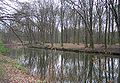
Stever upper course in front of the first basic spring

Upper course with basic source

Information board The sources of the Baumberge

.jpg)

From there, the Stever flows amply meandering in a southerly direction through meadows and fields via Appelhülsen to Senden , where it feeds various lakes and graves in the Bürgerpark and at Schloss Senden, and at the castle the Dummersbach flows towards it. Then the Stever crosses the Dortmund-Ems Canal and the old arm of the canal ( Alte Fahrt ) under two canal bridges in a southerly direction, in order to take in the Nonnenbach and the Kleuterbach coming from Hiddingsel on the right-hand side on its way to Lüdinghausen .
In Lüdinghausen ( 52 m above sea level ) the Stever divides and flows through the city with three arms (Vischeringsche Stever, Mühlenstever, Ostenstever). Before the Vischeringsche Stever and the Mühlenstever unite in the south of the city center to form the Alte Stever, the water from the former feeds the moat of the Vischering and Lüdinghausen moated castles . About one kilometer after the formation of the Alte Stever, it unites with the Oststever, which was artificially created in the 1930s because of the regular floods, and the river leaves Lüdinghausen reunited as the Stever.

Watermill in Lüdinghausen

Vischering Castle moat

Lüdinghausen Castle

Culvert to cross the Dortmund-Ems Canal


Then the Beverbach flows out on the left , shortly afterwards the Seppenrader Bach on the right. The Teufelsbach and the Flothbach flow from the Nordkirchen area on the left . After two further tributaries without a name, the Stever takes on the Funne coming from Selm and the Ternsche as the drainage of the Ternscher See on the left. Then it crosses under the Dortmund-Ems Canal and the Alte Fahrt one more time; this time in an east-west direction. The Stever flows under the remarkable arched bridge of the Alte Fahrt . North of Olfen ( 40 m ), where it was renatured to the Steveraue , it flows past the Füchtelner Mühle, feeds the Hullern reservoir (near Hullern ) and the Haltern reservoir , where the Mühlenbach flows to the right.
Stever near Selm

Canal bridge of the Alte Fahrt over the Stever

Steveraue in Olfen
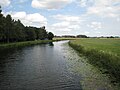
Stever near Haltern am See


Shortly below the dam wall , it flows into the Lippe at a height of 34 m at Haltern am See .
From 2006 to 2007 the catchment area of the Stever was a pilot project of the state government of North Rhine-Westphalia on the EU Water Framework Directive . On the basis of the pilot project program of measures in the catchment area of the Stever , the manual of the Federal Environment Agency for the situation in North Rhine-Westphalia was revised and tested.
Catchment area and tributaries
The catchment area of the Stever is 924.126 km² . Their tributaries include - with orographic allocation (l = left-hand side, r = right-hand side) , water length, catchment area size (both if known), mouth and water code number (GKZ) (viewed downstream) :
- Helmerbach (l; 15.8 km, 33.5 km²), near Senden (2788-2)
- Dümmer (l; 14.2 km, 32.0 km²), in Senden (2788-32)
- Nonnenbach (r; 21.7 km, 36.8 km²), near Lüdinghausen- Wessels (2788-34)
- Kleuterbach (r; 24.8 km, 118.4 km²), near Lüdinghausen-Elvert (2788-4)
- Beverbach (l; 11.4 km, 25.9 km²), near Lüdinghausen (2788-54)
- Teufelsbach (l; 12.1 km, 36.9 km²), near Lüdinghausen-Ernen (2788-56)
- Funne (l; 22.2 km, 55.3 km²), near the Ternscher See (2788-6)
- Ternsche (l), outflow of the Ternscher See to the nearby Stever (2788-71)
- Selmer Bach or Passbach (l; 12.0 km, 26.3 km²), near Ternsche (in 2788-72)
- Halterner Mühlenbach (r; 30.7 km, 295.6 km²), near Haltern- Sythen in the Haltern Reservoir (2788-8) through which the river flows
Localities
Localities on the Stever are:
Mills
As usual in Münsterland, the watercourse was used by numerous mills, here is an excerpt:
- Watermill in Stevern am Hof Schulze-Westerath, Stevern 37, earliest documented mention as a mill in 1599
- Stiftsmühle and Westerodemühle in Stevern
- Groß-Schonebeck's watermill near Appelhülsen
- Vischering's grain and oil mill
- Mill of the cathedral capitular "Borg"
- Füchtelner mill
- Kakesbeck's grain and oil mill
Renaturation
As part of the Regionale 2016, two weirs and other transverse structures in Senden were removed as a component of the WasserWege Stever project and the Stever partially re-routed.
Individual evidence
- ↑ a b c German basic map 1: 5000 in Topographical Information Management, Cologne District Government, Department GEObasis NRW ( information )
- ↑ a b c d e Topographical Information Management, Cologne District Government, Department GEObasis NRW ( information )
- ↑ a b German Hydrological Yearbook 2006 Stever / Olfen-Füchtelner Mühle ( Memento of the original from June 22, 2015 in the Internet Archive ) Info: The archive link was inserted automatically and has not yet been checked. Please check the original and archive link according to the instructions and then remove this notice. (PDF, 57.2 kB)
- ↑ a b District government of Münster: Water Framework Directive - Stever pilot project ( Memento from July 23, 2012 in the web archive archive.today ), from bezreg-muenster.nrw.de, on archive.is
- ↑ Water directory of the State Office for Nature, Environment and Consumer Protection NRW 2006 ( Memento from February 15, 2010 in the Internet Archive ) (PDF; 1.03 MB)
- ↑ Stever - mill profiles of the house Vischering. Retrieved May 1, 2020 .
- ↑ Stever - mill profiles Füchtelner mill. Retrieved May 1, 2020 .
- ↑ Stever - mill profiles of the house Kakesbeck. Retrieved May 1, 2020 .
- ↑ Sigmar Syffus: Experience the living river. Retrieved March 16, 2020 .
- ^ Rüdiger Hagen: Historic mills and their technology . Reprint-Verlag-Leipzig, 2004, p. 115
Web links
- Layers of time at the Stever - track down the cultural landscape (Westphalia regional), on lwl.org
- More life for Stever, Heubach and Co , The brooks and the groundwater in the Lippe area - condition, causes of pollution and measures , on lippe.nrw.de (PDF; 2.4 MB)