Lohrberg (Siebengebirge)
| Lohrberg | |
|---|---|
|
The Lohrberg by nuns Stromberg seen from |
|
| height | 432.8 m above sea level NHN |
| location | Koenigswinter , North Rhine-Westphalia |
| Mountains | Siebengebirge |
| Dominance | 0.85 km → Löwenburg |
| Notch height | 88 m ↓ watershed between Fonsbach and Einsiedlerbach |
| Coordinates | 50 ° 40 ′ 17 " N , 7 ° 14 ′ 57" E |
| rock | Trachyte and trachyte tuff |
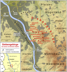
The Lohrberg is one of the seven great mountains of the Siebengebirge . At 432.8 m above sea level NHN it is the third highest mountain in the Siebengebirge.
geography
The Lohrberg is located in the area of the city of Königswinter on the border with the city of Bad Honnef , southwest of the Margarethenhöhe and the Lahr locality belonging to Ittenbach . Neighboring mountains and hills are clockwise from Lahr from Scheerkopf , Trenkeberg , Merkenshöhe , Erpentalskopf , Jungfernhardt , Wasserfall and Großer Ölberg .
The peculiarity of the Lohrberg is that it is basically a Siebengebirge in the Siebengebirge - the "Lohrberg Massif" consists of seven individual hills, which are all wooded peaks. The Lohrberg does not have a prominent peak with a corresponding view like other mountains of the Siebengebirge, so that despite its height it is rather unknown and rarely visited.
On the north side of the mountain Lohr arises from the Lohrberg source of the Rhine flowing to Mirbesbach .
geology
From a geological point of view, the Lohrberg consists essentially of trachyte , which takes up an area of 0.5 km² and is by far the largest complex of this type of rock in the Siebengebirge. It is characterized by one to two centimeters large Sanidin sprenglinge , which in comparison to the other local types of trachyte are both larger and occur more frequently.
history
The names and place names, which are provided with the Old High German word Loh , are usually associated with forest and trees . The name of the Lohrberg can also be traced back to the vegetation that has formed on the trachyte and trachyte tuff .
Web links
Individual evidence
- ↑ Information according to the digital terrain model and digital topographic map 1: 25,000, 1: 50,000 and 1: 100,000 (available in the TIM-online map service )
- ^ Geological State Office North Rhine-Westphalia (ed.); Gangolf Knapp, Klaus Vieten: Geological map of North Rhine-Westphalia 1: 25,000. Explanations for sheet 5309 Königswinter . 3rd, revised edition, Krefeld 1995, pp. 30/31.

