Dollendorfer Hardt
| Dollendorfer Hardt | |
|---|---|
|
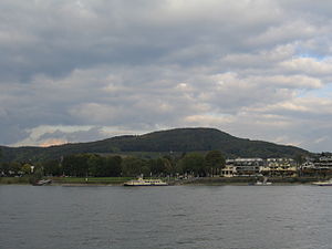
The Dollendorfer Hardt, viewed from the banks of the Rhine near Bonn- Bad Godesberg |
|
| height | 246.7 m above sea level NHN |
| location | Königswinter - Oberdollendorf |
| Mountains | Siebengebirge |
| Coordinates | 50 ° 42 '16 " N , 7 ° 11' 55" E |
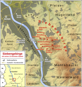
The Dollendorfer Hardt is a mountain of the Siebengebirge and its northernmost elevation. It is located east of Oberdollendorf in the Königswinter urban area, right on the border with Bonn . The wooded hilltop is 246.7 m above sea level .
The southern neighboring mountains of the Hardt are the Falkenberg and the Weilberg , to the north follows the Ennert with Juffernberg and Paffelsberg . To the east lie the Casseler Heide and the lower hill country . There are several vineyards on the western slope through which a wine trail leads. It borders directly on the built-up areas of Oberdollendorf and Römlinghoven , on the other slopes there are larger roads: Landesstraße 268 (Heisterbacher Straße) in the south, L 490 (Langemarckstraße) in the north and K 25 in the east. Above the vineyards, on the northern side of the valley, there is also the Voranhöhe or the envelope viewpoint .
Like the entire Siebengebirge, the Hardt is under nature protection and is a popular hiking area, it is also located on the Rheinsteig . The western slope includes the individual vineyards Rosenhügel , Laurentiusberg and Sülzenberg of the large Petersberg site .
Footnotes
- ↑ Information according to the digital terrain model and digital topographic map 1: 25,000, 1: 50,000 and 1: 100,000 (available in the TIM-online map service )
- ↑ Individual vineyards in the Middle Rhine region ( Memento from May 6, 2014 in the Internet Archive ) (PDF; 152 kB), Deutsches Weininstitut GmbH Mainz, as of 2011


