
Large area Petersberg (Siebengebirge)


The Großlage Petersberg is a viticulture - Großlage in the area Siebengebirge of the certain growing area Middle Rhine . The former cultivation area in the Siebengebirge has been reduced from around 500 ha to around 20 ha today. The name giver of the large location is the Königswinterer Petersberg .
Single layers
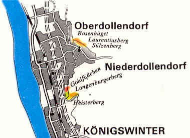
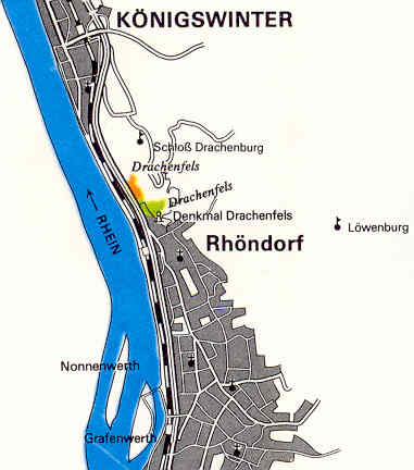
The large area comprises nine individual layers , which extend to the towns and cities of Niederdollendorf and Oberdollendorf (city of Königswinter ), Königswinter, Rhöndorf (city of Bad Honnef ) and Beuel (city of Bonn ). The Oberdollendorfer individual layers Sülzenberg , Laurentiusberg and Rosenhügel extend on the western slope of the Dollendorfer Hardt and have a clay and loess soil on Grauwacke . The Goldfüßchen , Heisterberg and Longenburgerberg sites in neighboring Niederdollendorf are based on partly sandy loam. The largest areas of the large area are by far above the banks of the Rhine on the Drachenfels , whose two vineyards belong to Königswinter in the north and Rhöndorf in the south and are characterized by trachyte and stony loam soils. The small growing area on the Rheinaue on the right bank of the Rhine has a soil with gravelly sandy loam.
The Goldfüßchen and Longenburgerberg sites are currently not planted . The Heisterberg , which had also not been cultivated since the 1980s and was first mentioned in 1329 as Paffinroyt , was replanted in 2002. There are no individual layers on the namesake of the large site itself, the Petersberg. The Heisterberg vineyard, which is still cultivated, can be attributed to the north-western slope of the mountain, also known as the Kellerberg .
| Single layer | Area (in hectares) |
Height in meters above sea level NHN |
location |
|---|---|---|---|
| Rose hill | 3 | 87-140 | Oberdollendorf 50 ° 42 ′ 9 ″ N, 7 ° 11 ′ 22 ″ E |
| Rheinaue | 1 | 50-60 | Bonn 50 ° 42 ′ 54 ″ N, 7 ° 7 ′ 59 ″ E |
| Laurentiusberg | 2 | 72-132 | Oberdollendorf 50 ° 42 ′ 7 ″ N, 7 ° 11 ′ 23 ″ E |
| Sülzenberg | 3 | 84-143 | Oberdollendorf 50 ° 42 ′ 2 ″ N, 7 ° 11 ′ 33 ″ E |
| Gold feet | 1 | 74-134 | Niederdollendorf 50 ° 41 ′ 23 ″ N, 7 ° 11 ′ 25 ″ E |
| Longenburgerberg | 4th | 68-136 | Niederdollendorf 50 ° 41 ′ 17 ″ N, 7 ° 11 ′ 27 ″ E |
| Heisterberg | 2 | 78-136 | Niederdollendorf 50 ° 41 ′ 20 ″ N, 7 ° 11 ′ 32 ″ E |
| Drachenfels | 12 | 57-137 | Rhöndorf 50 ° 39 ′ 41 ″ N, 7 ° 12 ′ 39 ″ E |
| Drachenfels | s. O. | 57-138 | Königswinter 50 ° 39 ′ 53 ″ N, 7 ° 12 ′ 14 ″ E |
swell
Web links
- The wine locations and vineyards of the Middle Rhine including the location classification
- Individual layers in the Middle Rhine growing area. ( Memento from May 6, 2014 in the Internet Archive ) (PDF; 152 kB), Deutsches Weininstitut GmbH Mainz, as of November 6, 2006.
- The individual layers in an interactive map