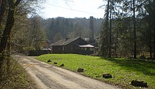
Brickyard (Rheinbreitbach)
The brickyard is a residential area of the Rheinbreitbach community in the Rhineland-Palatinate district of Neuwied . The eastern part of the group of houses belongs to the Scheuren district and the urban area of Unkel .
location
The group of houses is at a good 110 m above sea level. NHN , about 600 m east of the outskirts of Rheinbreitbach am Breitbach . It is accessible via the Westerwaldstraße (Rheinbreitbach - Breite Heide ), which runs around 75 m to the north .
history
The brick factory was built on a copper smelter that had existed since at least 1668. Until 1728 it was used by the Virneberg copper mines (above Rheinbreitbach) and St. Marienberg (near Bruchhausen ), then only used by the Virneberg. In 1817 it was listed as a pitch and smelting works as well as an ironworks with 22 inhabitants, and in 1830 as an ironworks . The smelter was shut down around 1840, but was still inhabited. In 1843 it had nine residents, and in 1885, as a residential area for the community of Scheuren, it had two residents in a residential building.
The raw materials processed in the brickworks included clay , decalcified loess and Devonian clay and silt stones below it . The roof structure of the Hoffmann ring kiln in the brickworks was destroyed in a bombing raid in World War II and then rebuilt in different ways. In the census on May 25, 1987, the brickyard residential area (group of houses) had fewer than ten residents.
Despite the changes, the brickworks' ring kiln is under monument protection as a cultural monument , the entry in the list of monuments of the state of Rhineland-Palatinate as an industrial- historical cultural asset took place at the end of 1997. The protection was accompanied by a legal dispute and prevented a planned commercial use of the site on which several small businesses should be settled.
Individual evidence
- ↑ Jürgen Fuchs: From the history of the St. Marienberg mine
- ^ The government district of Coblenz according to its location, limitation, size, population and division ... , Coblenz: Pauli, 1817; Page 59
- ↑ Friedrich von Restorff : Topographical-statistical description of the Royal Prussian Rhine Province , Nicolai, Berlin and Stettin 1830, page 676
- ↑ Jürgen Fuchs: Copper slag
- ↑ Topographical-statistical overview of the government district of Coblenz , Coblenz: Hölscher, 1843, page 63
- ^ Community encyclopedia for the Kingdom of Prussia. Volume XII Province of Rhineland . Publishing house of the Royal Statistical Bureau, 1888, p. 44. ( online PDF )
- ^ Geological State Office North Rhine-Westphalia (ed.); Gangolf Knapp, Klaus Vieten: Geological map of North Rhine-Westphalia 1: 25,000. Explanations for sheet 5309 Königswinter . 3rd, revised edition, Krefeld 1995, p. 52.
- ^ State Statistical Office Rhineland-Palatinate - Official directory of the municipalities and parts of the municipality
- ^ General Directorate for Cultural Heritage Rhineland-Palatinate (ed.): Informational directory of cultural monuments - Neuwied district. Mainz 2019, p. 58 (PDF; 6.4 MB).
- ↑ The old brickworks becomes a bone of contention , General-Anzeiger , April 24, 1998, p. 6
Coordinates: 50 ° 36 ′ 57 " N , 7 ° 14 ′ 45" E
