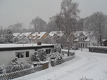
Broad heather
The "Breite Heide" is a district of the local community Rheinbreitbach in the Rhineland-Palatinate district of Neuwied . The settlement area comprises around 200 houses and has an estimated population of 300–500.
geography
The district of "Breite Heide" is a self-contained settlement that is about one kilometer east of the center of Rheinbreitbach. There is only one completely paved road to the settlement, which partly runs in the valley of the Breitbach , so that there is no through traffic. The settlement area, which extends a good one kilometer in an east-north-east-west-south-west direction, is surrounded by forest and lies on terrain that rises slightly to the east-north-east at the northern end of the so-called Linz terrace , an almost model-preserved part of the main Rhenish terrace of the Middle Rhine Bay , at 180 m above sea level. NHN to 194 u m. NHN . The northeastern part is on the southern edge of the forest district Hinten on the Breiten Heide ⊙ and the southwestern part on the Mühlenberg ⊙ , a ridge between the Breitbach in the south and the Ziegenborn in the north. The forest district of Vorn on the Breiten Heide ⊙ is located north of the district "Breite Heide".
From a geological point of view, the Breite Heide belongs to the younger main terrace of the Rhine Valley, the deposits of which are largely made up of sandy gravel .
history
The history of the Breiten Heide begins with the beginnings of mining in the 16th and 17th centuries. Century in Rheinbreitbach. At that time there were only factory buildings and the house of the mine director. The tunnels run through the whole mountain and made it difficult for the later development as there was a risk of collapse. After the mining became unprofitable and ultimately stopped, the community built a sports field that was used for the elementary school to hold physical education classes. At the beginning of the 1960s, it was demolished again in order to make development feasible. The "Breite Heide" known by its current name was created in the 1960s after Bonn had established itself as the seat of government and triggered settlement pressure in the region. Young families and civil servants moved to Rheinbreitbach and the surrounding area because of the quiet location. A building boom swept through the community and new houses and settlement areas were built. Today some crossroads of the miners, the former pond , chutes in the rock, a circulating tunnel and a huge pile of rubble remind of the former mine and the former purpose of the Breiten Heide.
Attractions
- (partially) restored circulation tunnel
- Koppelkreuz (on the paddock between Breite Heide and Rheinbreitbach)
- Clouthe Cross (memorial in memory of the Clouth family, rebuilt in 1981)
- Virneberger Kreuz (from 1840, renewed in 1874 and 1986)
- Bergwergskreuz
- Schnitzler cross
- Blood cross
- rare minerals and rocks from the former mine
- Wayside shrine Eye of God (erected in the middle to the end of the 19th century as a warning against wood thieves at 50 ° 37 ′ 33.3 ″ N , 7 ° 16 ′ 23.2 ″ E )
- V1 launch ramps (ruin in the direction of Bruchhausen; 50 ° 37 ′ 30.3 ″ N , 7 ° 16 ′ 22.5 ″ E )
traffic
On school days, the number 133 bus runs on the Breiten Heide and goes to Unkel via Rheinbreitbach. There is also a shared taxi, which can be requested on the basis of a timetable at the conditions of local public transport.
Web links
Individual evidence
- ↑ Heinrich Müller-Miny: The Middle Rhine region and its natural structure . In: Federal Institute for Regional Studies (Ed.): Reports on German Regional Studies . Volume 21, Issue 2 (September 1958), self-published by the Federal Institute for Regional Studies, Remagen 1958, pp. 193–233 (here: p. 220).
- ^ Geological State Office North Rhine-Westphalia (ed.); Gangolf Knapp, Klaus Vieten: Geological map of North Rhine-Westphalia 1: 25,000. Explanations for sheet 5309 Königswinter . 3rd, revised edition, Krefeld 1995, p. 40.
- ↑ The Clouthe Cross ( Memento of the original from March 4, 2016 in the Internet Archive ) Info: The archive link was inserted automatically and has not yet been checked. Please check the original and archive link according to the instructions and then remove this notice.
- ↑ Brothers Christian and Engelbert Rhodius , Heimatverein Rheinbreitbach eV
literature
- Rheinbreitbach then and now, 1974, Heimatverein Rheinbreitbach
Coordinates: 50 ° 37 ′ 11 " N , 7 ° 14 ′ 59" E


