Isenburg (family castle)
| Isenburg | ||
|---|---|---|
|
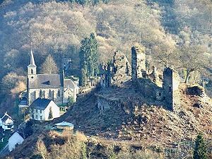
Isenburg ruins, old school house and parish church in the background |
||
| Creation time : | around 1100 | |
| Castle type : | Hilltop castle | |
| Conservation status: | ruin | |
| Standing position : | Ganerbe | |
| Place: | Isenburg | |
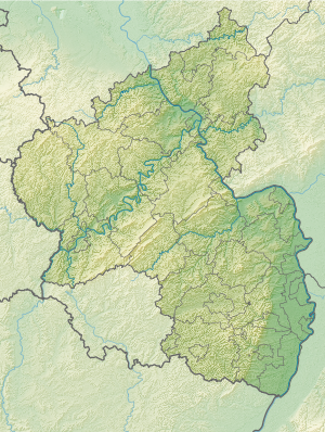
| Geographical location | 50 ° 28 '34.5 " N , 7 ° 35' 27.8" E | |
| Height: | 250 m above sea level NN | |
|
|
||
The ruins of the Isenburg , the parent company of the Isenburg family , are located in the Rhineland-Palatinate town of Isenburg in the Westerwald .
location
The Höhenburg is located about ten kilometers as the crow flies northeast of the cities of Neuwied and Bendorf on the Rhine and southwest of the small Westerwald town of Dierdorf . It stands on an approximately 250 meter high mountain ledge above the town of the same name at the confluence of the Ommelsbach, Wiebelsbach and Iserbach with the Saynbach .
history
The Isenburg is mentioned for the first time in a document from Archbishop Bruno von Trier in 1103 . The brothers Reinbold and Gerlach von Isenburg named in this document were first mentioned by Archbishop Poppo von Trier in 1041 and 1042 in documents about the possession of the St. Simeon-Stift zu Hönningen .
The castle was probably built around 1100 by Reinbold and Gerlach von Isenburg in the area of a manorial estate of the Fulda Abbey as their ancestral seat. Due to the very early branching of the sex into several lines, it soon had the character of a Ganerbeburg , i.e. a castle community of members of different family lines, who are mostly related to each other.
In 1625 the castle was still inhabited. At that time it served primarily as a widow's residence. In 1633 it was occupied by Spanish troops but not destroyed. With the death of Count Ernst von Isenburg-Grenzau in 1664, the Nieder-Isenburg line died out. Due to an inheritance dispute, the castle was then left to decay. From 1666, the Counts of Walderdorff and Counts of Wied-Neuwied (transferred to the Counts of Wied-Runkel in 1694) became sovereigns as part of a condominium . The castle ruins now belong to the Prince of Wied in Neuwied .
In 1771 the southern half of the keep collapsed along with the staircase. Because it was feared that the rest of the tower might one day fall on the village, they considered shooting it down with cannons or blowing it up. Ultimately, this project, just like the idea of removing the ruins by hand, was abandoned because of the danger and the costs in the hope that the wall would remain standing for another 50 years.
According to Isenburg municipality accounts from 1783 to 1810, the ruins served as a quarry .
Since 2005, the friends' group of Isenburg e. V. ”in connection with the“ State Office for the Preservation of Monuments Rhineland-Palatinate ”is about preserving the castle ruins for posterity and making them fully accessible to the public again.
Castle complex
The Isenburg is a Romanesque hilltop castle and was laid out very generously and spaciously. It is the second oldest castle in the Neuwied district. The steep hilltop on which it was built is surrounded by three quarters of the Sayn and Iserbach and connected to the Ebenfelder Höhe in the north by a narrow saddle .
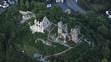
Its extension was around 70 meters in north-south direction and around 30 meters in east-west direction. It was separated into a north and a south part by a transverse wall. The keep was not, as usual, on the attack side (in the north), but in the southwest corner on a crag. From here the Sayntal could be monitored well in both directions. Its floor plan is a square with a side length of 9 m. Parts of the north and east walls of the second and third floors still rise above the 2 m thick masonry of the vaulted basement. The tower should have had a height of 20 to 25 m. The still recognizable high entrance at a height of about 6 m led to the first floor, underneath there was a round-arched entrance to the basement.
In the 13th century there were four residential buildings here, namely the Isenburg or old house , the Kobernhaus , the Wied and the Frauenhaus or Runkelsche Haus . The women's shelter was also known as the Grenzau House . They used the keep, gates and bridges together. From these houses, especially on the west side, some wall remains over 10 m high with gables, windows, consoles etc. have been preserved. Under the largest, apparently burnt down house, there was a barrel-vaulted cellar, which largely collapsed in the 1930s.
Fortification of the castle patch
The settlement at the foot of the Isenburg was a castle town of the same name and had city rights and the status of a private place. However, the founding of a city did not come about, the valley location of the place offered no expansion opportunities.
The Burgflecken was fortified at the beginning of the 14th century. The fortification extended over a considerable area around the castle and valley and not only protected the place, but also served the castle as an advanced security. It consisted of a wall and a moat , some of which were probably just a bridge and had four gates. One of the gates, the Alte Porz (Old Gate), located in the center of the village directly on the B 413, is still one of Isenburg's landmarks and has been home to a local museum since 2008. It was created as an outer protective gate at the castle entrance. This gatehouse has an ogival gate opening which, covered by beams, supports a half-timbered structure, the gable roof of which is adorned with a bell tower. On one side there is a stump of what was probably an original round tower built up from rubble stones. Such a tower may also have existed on the opposite side. An attached half-timbered house probably served as an apartment for the guards. This gatehouse was restored in 1959 and is in good structural condition. The second gate is the shield gate above the cemetery by the parish church, on the old path over the Ebenfeld to Kleinmaischeid. It is still almost in its original state. It is a square tower with a side length of 4.5 m and a height of 9 m. It was three-story and has an ogival gate opening.
literature
- Albert Meinhard: Castles in the Neuwied district . In: Landkreis Neuwied (Hrsg.): Heimat-Jahrbuch des Landkreis Neuwied 1971 .
- Alexander Thon, Stefan Ulrich: "... like a monarch enthroned in the middle of his court". Castles on the Lower Middle Rhine . Schnell & Steiner, Regensburg 2010, ISBN 978-3-7954-2210-3 , pp. 88-93.
- Eugen Wasser: Isenburg in Sayntal . 1st edition. Neusser Druck- und Verlagsgesellschaft, Neuss 1997, ISBN 3-88094-806-2 ( Rheinische Kunststätten . Issue 425).
- Eugen Wasser: Isenburg and the Isenburger - 900 years of village history, Geiger-Verlag, Horb 2002
Web links
- Website of the Freundeskreis der Isenburg e. V.
- Isenburg im Sayntal, part 1 and part 2
- Reconstruction drawing by Wolfgang Braun


