Upper ears
|
Upper ears
Local community Döttesfeld
Coordinates: 50 ° 36 ′ 46 ″ N , 7 ° 34 ′ 28 ″ E
|
|
|---|---|
| Height : | approx. 192-277 m above sea level NHN |
| Residents : | 76 (Jun 30, 2007) |
| Incorporation : | 7th June 1969 |
| Postal code : | 56305 |
| Area code : | 02685 |
|
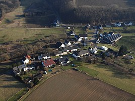
Aerial view of Upper Ferries
|
|
Oberehren is a part of the local community Döttesfeld in the district of Neuwied in Rhineland-Palatinate . The place was an independent municipality until June 7, 1969 and is now part of the Puderbach Association .
location
Oberehren is located in the Rhine-Westerwald Nature Park and is surrounded by the Wied Forest . The place is nine kilometers as the crow flies southwest of the city of Altenkirchen (Westerwald) and 20 kilometers north-northeast of Neuwied . The district of Oberehre borders in the north on Ascheid (district of Niederwambach ), in the east on Haberscheid and in the southeast on Reichenstein (districts of Puderbach ), in the south on Dürrholz , in the south-west on Bauscheid , in the west on Döttesfeld and in the north-west on Niederähre im Altenkirchen district (Westerwald).
The Holzbach flows on the border with Haberscheid . Oberehren is located on the district road 131 between Breitscheid and Haberscheid. The state road 267 is about one kilometer northeast of Oberähre.
history
Oberehren was mentioned in a document in 1502, when the Cistercian Abbot Johann Fessersmyt sold his farm in Oberarus to the Abbey of Marienstatt . The place belonged to the parish of Puderbach. In 1806 Oberehren came from the County of Wied-Runkel to the Duchy of Nassau . As part of the parish Puderbach the village belonged there to the Office Dierdorf in the administrative district of Ehrenbreitstein . After the agreements made at the Congress of Vienna in 1815, the area around Upper Ferries became part of the Kingdom of Prussia . There the place belonged to the mayor's office Puderbach in the Neuwied district in the Koblenz administrative district . This became part of the Rhine Province in 1822 .
From the 18th to the early 20th century, iron ore mining was carried out in Oberarus . The mayor's office in Puderbach was renamed to Amt Puderbach in 1927 and merged ten years later with the Amt Niederwambach to form the new Amt Puderbach, from which today's association municipality Puderbach was founded on January 1, 1968 . The municipality of Oberehren was incorporated into Döttesfeld on June 7, 1969 as part of a regional reform. At the time of the dissolution, the community had 93 inhabitants.
Web links
Individual evidence
- ^ Christian Hillen (ed.): The Cistercian Abbey of Marienstatt. The dioceses of the ecclesiastical province of Cologne. Walter De Gruyter, Berlin / Boston 2017, ISBN 978-3-11-046735-2 , p. 224.
- ↑ Certificate of award for the Oberähre mine. In: Official Journal of the Royal Government of Coblenz for the year 1874. Coblenz 1873, p. 60.
- ↑ Official municipality directory 2006 ( Memento from December 22, 2017 in the Internet Archive ) (= State Statistical Office Rhineland-Palatinate [Hrsg.]: Statistical volumes . Volume 393 ). Bad Ems March 2006, p. 175 (PDF; 2.6 MB). Info: An up-to-date directory ( 2016 ) is available, but in the section "Territorial changes - Territorial administrative reform" it does not give any population figures.
