Bad Hönningen municipality
| coat of arms | Germany map | |
|---|---|---|

|
Coordinates: 50 ° 31 ' N , 7 ° 18' E |
|
| Basic data | ||
| State : | Rhineland-Palatinate | |
| County : | Neuwied | |
| Area : | 55.29 km 2 | |
| Residents: | 12,067 (Dec. 31, 2019) | |
| Population density : | 218 inhabitants per km 2 | |
| License plate : | NO | |
| Association key : | 07 1 38 5002 | |
| Association structure: | 4 municipalities | |
| Association administration address : |
Marktstrasse 1 53557 Bad Hönningen |
|
| Website : | ||
| Mayor : | vacant (representative: Reiner W. Schmitz) | |
| Location of the Bad Hönningen community in the Neuwied district | ||
The Verbandsgemeinde Bad Hönningen is an administrative unit in the legal form of a regional authority in the Neuwied district in Rhineland-Palatinate . The municipality of the association includes the city of Bad Hönningen and three independent local communities , the administrative seat is in the eponymous city of Bad Hönningen.
The area of the Verbandsgemeinde is located on the Middle Rhine northwest of Neuwied .
Association members communities
| Local parish, city | Area (km²) | Residents |
|---|---|---|
| Bad Hönningen , city | 20.09 | 6.009 |
| Hammerstein | 7.20 | 334 |
| Leutesdorf | 10.79 | 1,725 |
| Rheinbrohl | 17.20 | 3,999 |
| Bad Hönningen municipality | 55.29 | 12,067 |
(Residents on December 31, 2019)
Population development
The development of the number of inhabitants in relation to the area of what is today the Bad Hönningen association; the values from 1871 to 1987 are based on censuses:
|
|
politics
Association municipal council
The local council Bad Hönningen consists of 28 honorary council members, who in the local elections on May 26, 2019 in a personalized proportional representation were elected, and the full-time mayor as chairman.
The distribution of seats in the municipal council:
| choice | SPD | CDU | FDP | GREEN | FWG | total |
|---|---|---|---|---|---|---|
| 2019 | 11 | 12 | 1 | 4th | - | 28 seats |
| 2014 | 13 | 13 | - | 2 | - | 28 seats |
| 2009 | 14th | 12 | - | - | 2 | 28 seats |
| 2004 | 13 | 13 | - | - | 2 | 28 seats |
mayor
Reiner W. Schmitz (SPD) is currently responsible for the official business. Until December 31, 2017, Michael Mahlert (SPD) was elected mayor of the Verbandsgemeinde for 16 years, most recently in the direct election on January 11, 2015 with 63.4% of the vote for a further eight years. However, on January 1, 2018, Mahlert took on the role of first district councilor at the Neuwied district administration. The vacant position of mayor was not filled by a new election, since the association is expected to merge into a new regional authority from January 2021. In the meantime, an election for a new mayor has been arranged, which was originally supposed to take place in May 2020. Due to the COVID-19 pandemic in Germany , this was postponed to autumn 2020.
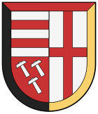
coat of arms
The blazon reads: “Split within a border triple stiffened by black, red and gold and divided at the front; at the top in front two red bars in silver, at the bottom three 2: 1 slanted silver hammers in red; behind in silver a continuous red bar cross. "
The content of the coat of arms documents the landlord and sovereign past of the administrative district. The two bars indicate the rule of Isenburg - Arenfels . The three hammers, coats of arms of the burgraves of Hammerstein , indicate that the towns of Nieder- and Oberhammerstein belong to the lordship of the castle. The Electorate of Trier cross indicates the electoral sovereignty - Arenfels rule and Hammerstein office - until 1803, as well as its membership in the Trier diocese . The shield border shows the colors of the Federal Republic of Germany. Legally valid since April 11, 1967, draft Adalbert. N. Schmitz.
Web links
Individual evidence
- ↑ a b c State Statistical Office Rhineland-Palatinate - population status 2019, districts, municipalities, association communities ( help on this ).
- ↑ State Statistical Office Rhineland-Palatinate - regional data
- ^ The regional returning officer RLP: Association council election 2019 Bad Hönningen. Retrieved August 18, 2019 .
- ↑ Blick-aktuell.de: Reiner W. Schmitz is now the representative of the VG Bad Hönningen. September 19, 2018, accessed December 18, 2019 .
- ^ Rhein-Zeitung: VG Bad Hönningen: Mahlert defends the mayor's post. January 11, 2015, accessed December 18, 2019 .
- ↑ The elections for the mayor of the Bad Hönningen community are postponed. Retrieved June 22, 2020 .


