
Steimel
| coat of arms | Germany map | |
|---|---|---|

|
Coordinates: 50 ° 37 ' N , 7 ° 38' E |
|
| Basic data | ||
| State : | Rhineland-Palatinate | |
| County : | Neuwied | |
| Association municipality : | Puderbach | |
| Height : | 326 m above sea level NHN | |
| Area : | 5.59 km 2 | |
| Residents: | 1267 (Dec. 31, 2019) | |
| Population density : | 227 inhabitants per km 2 | |
| Postal code : | 57614 | |
| Area code : | 02684 | |
| License plate : | NO | |
| Community key : | 07 1 38 070 | |
| Community structure: | 4 districts | |
| Association administration address: | Hauptstrasse 13 56305 Puderbach |
|
| Website : | ||
| Local Mayor : | Wolfgang Theis | |
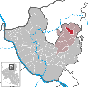
| Location of the municipality of Steimel in the Neuwied district | ||
  |
||


Steimel is a municipality in the Neuwied district in the north of Rhineland-Palatinate . She belongs to the Verbandsgemeinde Puderbach . Steimel is a state-approved resort .
geography
The resort is located northeast of Puderbach in the Rhine-Westerwald nature park .
Steimel includes the districts of Alberthofen , Sensenbach and Weroth as well as the residential areas Berghof, Birkenhof, Luisenhof, Marthaheim and Niederwambachermühle.


history
Steimel is one of the oldest settlements in the Verbandsgemeinde Puderbach, first mentioned in 1320 as Steynbule and Steynboll, in 1460 Steymbell and from the middle of the 16th century Steymel or Steimel. The name is interpreted as "Steinbul", the basic word Bühl denotes a hill. The interpretation “Stein-Mal” and the reference to a possible pagan thing - or place of sacrifice in Germanic times is unlikely, since the basic word Bühl is still recognizable in the old forms of name.
Steimel received market rights early on. Mainly products from farming and handicrafts activities as well as farming utensils were traded, later the trade in cattle was added. The market was under the protection of the Counts of Wied , for whom the market taxes were a source of income. In 1559 the market square was surrounded by a wall and moat to protect it against attacks. In 1633 the place was devastated by "foreign war races" and the survivors died of the plague.
In the period that followed, up to over twenty markets were held annually instead of the original three market days. Steimel developed into the most important market place in the Wiedische Grafschaft. On some market days, the number of large cattle increased to over 1,000. In 1957, 13 markets were still held.
Today's “Potato Market”, which takes place every autumn, is a reminder of the old market rights, just like the old oak trees on the market square.
Until the renaming on May 1, 1967, the community was called Alberthofen. On June 7, 1969, today's community was formed from the communities of Steimel and Weroth.
On February 26, 2012, a wolf was spotted and photographed in the Westerwald near Weroth for the first time in 130 years. However, he was illegally shot by a hunter from Bad Honnef on April 21, 2012.
- Cultural monuments
See the list of cultural monuments in Steimel
- Population development
The development of the population of Steimel in relation to today's municipality, the values from 1871 to 1987 are based on censuses:
|
|
politics
Municipal council
The municipal council in Steimel consists of 16 council members, who were elected in the local elections on May 26, 2019 in a majority vote, and the honorary local mayor as chairman.
mayor
Wolfgang Theis became local mayor of Steimel in 2014. In the direct election on May 26, 2019, he was confirmed in his office for another five years with a share of 74.09% of the votes. His predecessor Michael Anhäuser had held the office for 18 years.
coat of arms
|
|
Blazon : “Split by a curled green tip, inside a silver chapel with a gate in natural colors and a red tower roof on a growing silver cairn, in front four red diagonal bars in gold, covered with a blue peacock stepping left from the edge of the shield, behind in silver a red scales . "
The coat of arms was approved on July 28, 1972 by the Koblenz district government . |
| Justification of the coat of arms: In the emblems, the peacock indicates the former Wiedische sovereignty . That Steimel is an ancient market place is shown by the scales. The cairn symbolizes the name of the community ("Steinbul" = Steimel). The chapel refers to the Martins chapel that used to exist. |
traffic
The next motorway junction is Neuwied on the A3 . The nearest ICE - Station is in Montabaur on the high-speed line Cologne-Rhine / Main .
literature
- Walter Rummel: Steimel - a rural market in the Westerwald of the 19th century. Scenario of a lost conviviality. In: Yearbook for West German State History 28 (2002). Pp. 395-406.
Web links
- Website of the local community Steimel
- Local municipality Steimel on the website of the association municipality Puderbach
Individual evidence
- ↑ State Statistical Office of Rhineland-Palatinate - population status 2019, districts, communities, association communities ( help on this ).
- ^ A b State Statistical Office Rhineland-Palatinate: My village, my city. Retrieved July 11, 2019 .
- ↑ State Statistical Office Rhineland-Palatinate (ed.): Official directory of the municipalities and parts of the municipality. Status: January 2019 [ Version 2020 is available. ] . S. 52 (PDF; 3 MB).
- ↑ Official municipality directory (= State Statistical Office of Rhineland-Palatinate [Hrsg.]: Statistical volumes . Volume 407 ). Bad Ems February 2016, p. 186 (PDF; 2.8 MB).
- ↑ Official municipality directory (= State Statistical Office of Rhineland-Palatinate [Hrsg.]: Statistical volumes . Volume 407 ). Bad Ems February 2016, p. 179 (PDF; 2.8 MB).
- ↑ NABU confirms: There is a wolf in the Westerwald. In: Rhein-Zeitung. March 27, 2012, accessed February 11, 2018 .
- ↑ Jens Höhner: Trial of the dead wolf hunter has to pay a fine of 3500 euros. In: Rhein-Sieg-Anzeiger. January 17, 2013, accessed February 11, 2018 .
- ^ The Regional Returning Officer Rhineland-Palatinate: Local elections 2019, city and municipal council elections
- ^ Minutes of the public meeting of the Steimel local council. Ortgemeinde Steimel, August 14, 2019, accessed on March 20, 2020 .
- ^ The Regional Returning Officer Rhineland-Palatinate: direct elections 2019. see Puderbach, Verbandsgemeinde, 14th line of results. Retrieved March 20, 2020 .
- ↑ Badge of honor of the country for three deserving citizens from the district. Michael Anhäuser. NR-Kurier, July 16, 2015, accessed on March 20, 2020 .

Cities: Bad Hönningen | Dierdorf | Linz on the Rhine | Neuwied | Uncle . Municipalities: Anhausen | Asbach | Bonefeld | Breitscheid (Westerwald) | Bruchhausen | Buchholz (Westerwald) | Dattenberg | Datzeroth | Dernbach | Döttesfeld | Dry wood | Ehlscheid | Drake | Oath of May | Hammerstein (on the Rhine) | Hanroth | Hardert | Harschbach | Hausen (Wied) | Hümmerich | Isenburg (Westerwald) | Kasbach-Ohlenberg | Kleinmaischeid | Kurtscheid | Leubsdorf (on the Rhine) | Leutesdorf | Linkenbach | Marienhausen | Meinborn | Melsbach | Neustadt (Wied) | Niederbreitbach | Niederhofen | Niederwambach | Oberdreis | Oberhonnefeld-Gierend | Upper wheels | Ockenfels | Puderbach | Ratzert | Raubach | Rengsdorf | Rheinbreitbach | Rheinbrohl | Rodenbach near Puderbach | Rossbach (Wied) | Rüscheid | Saint Catherine | Stebach | Steimel | Street house | Thalhausen | Urbach (Westerwald) | Vettelschoss | Waldbreitbach | Windhagen | Woldert .