
Forest (if knowledge, victory)
| coat of arms | Germany map | |
|---|---|---|

|
Coordinates: 50 ° 48 ' N , 7 ° 41' E |
|
| Basic data | ||
| State : | Rhineland-Palatinate | |
| County : | Altenkirchen (Westerwald) | |
| Association municipality : | Hamm (victory) | |
| Height : | 272 m above sea level NHN | |
| Area : | 4.25 km 2 | |
| Residents: | 553 (Dec. 31, 2019) | |
| Population density : | 130 inhabitants per km 2 | |
| Postal code : | 57537 | |
| Area code : | 02682 | |
| License plate : | AK | |
| Community key : | 07 1 32 034 | |
| Community structure: | 8 districts | |
| Association administration address: | Lindenallee 2 57577 Hamm (Sieg) |
|
| Website : | ||
| Local Mayor : | Jürgen May | |
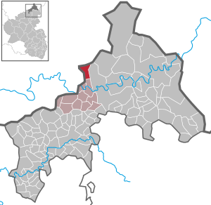
| Location of the local community of Forst in the district of Altenkirchen (Westerwald) | ||
  |
||

Forst ( ) is a municipality in the district of Altenkirchen (Westerwald) in Rhineland-Palatinate . It belongs to the community of Hamm (Sieg) .
geography
Geographical location
The community of Forst in the north central Siegbergland lies on a ridge to the right of the Sieg between the Bellingerbach in the west and the Holperbach in the east, about five kilometers northwest of Wissen on the border with North Rhine-Westphalia .
Community structure
In addition to the eponymous place, Forst also includes the districts of Dellingen, Hof Holpe, Kaltau, Lechenbach, Neuhöfchen, Seifen, Seifermühle and Wäldchen.
history
Until the middle of the 17th century, Forst belonged to the county of Sayn . After the introduction of the Reformation in the county of Sayn, the inhabitants were first Lutheran and later reformed . After the state division of the County of Sayn in the 17th century, Forst was part of the County of Sayn-Hachenburg .
Forst formed a separate administrative district called "Sende" within the parish of Hamm , to which the places Dellingen, Holpe, Kaltau, Lechenbach, Neu-Höfchen, Ober-Seifen, Seifen and Wäldchen also belonged. The county of Sayn-Hachenburg fell to the princes of Nassau-Weilburg by inheritance in 1799 . In connection with the formation of the Rhine Confederation , Forst came to the newly established Duchy of Nassau in 1806 .
Due to the agreements made at the Congress of Vienna (1815), the region was ceded to the Kingdom of Prussia . Under the Prussian administration, Forst was assigned to the Hamm mayor in the newly established Altenkirchen district ( Koblenz district ), which belonged to the Rhine province from 1822 onwards.
- Population development
The development of the population of the community of Forst, the values from 1871 to 1987 are based on censuses:
|
|
politics
Municipal council
The local council in Forst consists of twelve council members, who were elected by a majority vote in the local elections on May 26, 2019 , and the honorary local mayor as chairman.
mayor
Jürgen Mai is the local mayor of Forst. In the direct election on May 26, 2019, he was re-elected with a vote of 86.89%.
coat of arms
|
|
|
| Reasons for the coat of arms: In the upper triangle of the coat of arms, the golden leoparded lion appears on a red background as a sign of earlier membership of the County of Sayn . The bar in blue and gold symbolizes the two brooks, the Bellingerbach and Holperbach, at the same time the eight hemispheres symbolize the eight districts. As a symbol for the forest and for the place name, three fir trees stand on a golden background. |
Attractions
In the Seifermühle district there is the mill of the same name, which was first mentioned in 1603 as "Kaldauwer Mühle". This listed building was restored from 1987 to 1992 and can be viewed by appointment.
Personalities
- Sabine Bätzing-Lichtenthäler (* 1975), German politician, lives in Forst
literature
- Heinz Rötzel: Forest. From the history of a community. Roth 1988.
- Rolf Dieter Rötzel: The Seifermühle, a testament to craftsmanship, will be preserved for posterity. In: Heimat-Jahrbuch des Kreis Altenkirchen, 31. 1988, pp. 75–77.
- Daniel Schneider: The milling industry in the county of Sayn-Altenkirchen. In: Heimat-Jahrbuch des Kreis Altenkirchen 59. 2016, pp. 219–237.
- Daniel Schneider: The development of denominations in the county of Sayn in the plan. In: Heimat-Jahrbuch des Kreis Altenkirchen 58. 2015, pp. 74–80.
See also
Web links
Individual evidence
- ↑ State Statistical Office of Rhineland-Palatinate - population status 2019, districts, communities, association communities ( help on this ).
- ↑ State Statistical Office Rhineland-Palatinate (ed.): Official directory of the municipalities and parts of the municipality. Status: January 2018 [ Version 2020 is available. ] . S. 10 (PDF; 2.2 MB).
- ↑ See Daniel Schneider: The development of denominations in the county of Sayn in the ground plan, in: Heimat-Jahrbuch des Kreis Altenkirchen 58 (2015), pp. 74-80.
- ↑ Cf. Wilhelm Fabricius : Explanations of the historical atlas of the Rhine province, Volume 2: The map of 1789. Bonn 1898, p. 371.
- ^ Negotiations of the by resolution of the State Deputy Assembly ..., Volume 1 , 1836, p. 583.
- ↑ State Statistical Office Rhineland-Palatinate - regional data
- ^ The Regional Returning Officer Rhineland-Palatinate: Municipal Council Election 2019 Forst. Retrieved November 15, 2019 .
- ^ The State Returning Officer Rhineland-Palatinate: direct elections 2019. see Hamm (Sieg), Verbandsgemeinde, sixth result line. Retrieved November 15, 2019 .
- ↑ See Daniel Schneider: The mill trade in the county of Sayn-Altenkirchen, p. 221.
- ↑ On the historical development of the mills cf. Daniel Schneider: The milling industry in the county of Sayn-Altenkirchen, pp. 219–237.
- ↑ Cf. Rolf Dieter Rötzel: The Seifermühle, a testimony to craftsmanship, remains for posterity, pp. 75–77

Almersbach | Alsdorf | Altenkirchen (Westerwald) (city, seat of the district administration) | Bachenberg | Berod near Hachenburg | Berzhausen | Betzdorf (city) | Birch honey meal | Birch bump | Birnbach | Bitches | Brachbach | Breitscheidt | Bruchertseifen | Bürdenbach | Burglahr | Busenhausen | Daaden (city) | That | Dickendorf | Eichelhardt | Oak trees | Elves | Elkenroth | Emmerzhausen | Ersfeld | Etzbach | Eulenberg | Fensdorf | Fiersbach | Flammersfeld | Floodlight | Forest | Forstmehren | Friedewald | Friesenhagen | Fürthen | Gebhardshain | Gieleroth | Giershausen | Grünebach | Güllesheim | Hamm (victory) | Harbach | Hasselbach | Helmenzen | Helmeroth | Hemmelzen | Herdorf (city) | Haylofts | Hilgenroth | Hirz-Maulsbach | Horhausen (Westerwald) | Hövels | Idelberg | Ingelbach | Isert | Katzwinkel (victory) | Chew | Kescheid | Kettenhausen | Churchib | Churches (victory) (city) | Kraam | Krunkel | Malberg | Mammelzen | Mauden | More | Michelbach (Westerwald) | Mittelhof | Molzhain | Mudersbach | Nauroth | Neitersen | Niederdreisbach | Niederfischbach | Niederirsen | Niedersteinebach | Nisterberg | Obererbach (Westerwald) | Oberirsen | Oberlahr | Obernau | Obersteinebach | Oberwambach | Oils | Orfgen | Peterslahr | Pleckhausen | Splendor | Racksen | Reiferscheid | Rescuers | Rosenheim (District of Altenkirchen) | Roth | Rott | Scheuerfeld | Schöneberg | Stokes | Schutzbach | Seelbach (Westerwald) | Seelbach near Hamm (victory) | Soaps | Selbach (victory) | Sörth | Steinebach / Victory | Steineroth | Stürzelbach | Volkerzen | Wallmenroth | Walterschen | Weitefeld | Werkhausen | Weyerbusch | Willroth | Knowledge (city) | Wölmersen | Goat grove