
Volkerzen
| coat of arms | Germany map | |
|---|---|---|

|
Coordinates: 50 ° 43 ' N , 7 ° 41' E |
|
| Basic data | ||
| State : | Rhineland-Palatinate | |
| County : | Altenkirchen (Westerwald) | |
| Association municipality : | Altenkirchen-Flammersfeld | |
| Height : | 270 m above sea level NHN | |
| Area : | 1.98 km 2 | |
| Residents: | 85 (Dec. 31, 2019) | |
| Population density : | 43 inhabitants per km 2 | |
| Postal code : | 57612 | |
| Area code : | 02681 | |
| License plate : | AK | |
| Community key : | 07 1 32 110 | |
| Association administration address: | Rathausstrasse 13 57610 Altenkirchen |
|
| Website : | ||
| Local Mayor : | Knut Eitelberg | |
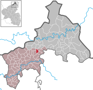
| Location of the local community Volkerzen in the district of Altenkirchen (Westerwald) | ||
  |
||

Volkerzen is a municipality in the Altenkirchen district in Rhineland-Palatinate . It belongs to the community of Altenkirchen-Flammersfeld .
Geographical location
Volkerzen is located west of Eichelhardt near the federal highway 256 leading from Altenkirchen to Hamm .
history
Volkerzen was first mentioned in 1473 in a document from the Marienstatt monastery . In 1578 and 1580 the place consisted of eight houses, which corresponds to about 50 residents. In 1714, the residents of Volkerzen, together with neighboring towns, tried in a petition to Duke Johann Wilhelm von Sachsen-Eisenach to remove the compulsory meal in the Altenkirchen mill and to build their own mill in Niedererbach . In 1718 this permit was granted.
Volkerzen belonged to the county of Sayn and after its division since the 17th century to the county of Sayn-Altenkirchen . Within the county, Volkerzen belonged to the parish of Altenkirchen, which also represented a secular administrative unit and exercised lower jurisdiction . In 1803 the county and thus also Volkerzen were awarded to the Principality of Nassau-Usingen (1806 Duchy of Nassau ) and came to Prussia in 1815 as a result of the resolutions of the Congress of Vienna in 1815 . Under the Prussian administration, Volkerzen belonged to the mayor's office in Altenkirchen in the newly formed district of the same name in the administrative district of Koblenz , which belonged to the Rhine province from 1822 onwards. In 1946 the community became part of the state of Rhineland-Palatinate .
Ecclesiastically, Volkerzen was assigned to the Altenkirchen branch church in Hilgenroth . Originally the parish of Altenkirchen belonged to the Archdiocese of Cologne . As a result of the Saynic Reformation , the inhabitants of Volkerzen were introduced to the Lutheran teaching in 1561 and the Reformed teaching in 1605 . Even today, around 55% of the residents are mostly members of the Evangelical Church.
- Population development
The development of the population of Volkerzen, the values from 1871 to 1987 are based on censuses:
|
|
politics
Municipal council
The council in Volkerzen consists of six council members, who in the local elections on May 26, 2019 in a majority vote were elected, and the honorary mayor as chairman.
coat of arms
|
|
Blazon : "Of blue and gold diagonally square , above a golden sun with eighteen wavy rays, in front an open blue book, behind a blue seven-stringed lyre and below three golden crossed ears, from which a golden plow protrudes on both sides." |
|
Reasons for the coat of arms: The symbols of the coat of arms stand for the essential elements of coexistence: The sun standing above all life, the Bible as the word of God, the lyre as a symbol for music, song and happiness as well as the plows and ears of grain as a symbol for the agricultural character of the village . Ore prospecting has not been very successful over the past 200 years.
The new municipal coat of arms was introduced in 1995 and changed after a draft from 1949 so that it corresponds to the heraldic guidelines. |
Mayor and mayor
| 1846–1867 Heinrich Weßler | 1919–1920 Wilhelm Enders | 1960–1973 Otto Altgeld |
| 1867–1883 Gerhard Schmidt | 1920–1929 Wilhelm Becker | 1973–1992 Erich Krämer |
| 1883–1888 Gottfried Schmidt | 1929–1946 Wilhelm Krämer | 1992–2004 Erhard Schäfer |
| 1888–1919 Heinrich Flemmer | 1946–1960 Artur Krämer | since 2004 Knut Eitelberg |
In the direct election on May 26, 2019, Knut Eitelberg was confirmed in his office for a further five years with 97.96% of the vote.
economy
Half of the non-built-up community area consists of forest and half of agricultural land. Unless state forest, the forest is managed by a forest interest group ; three farms have an average of around 53 hectares of agricultural land (as of 2007). The forest areas are also ideal for those seeking relaxation for hiking.
literature
- Inge Schäfer: Volkerzen. A Westerwalddorf yesterday and today , Volkerzen 1990.
- Daniel Schneider: The mill trade in the county of Sayn-Altenkirchen , in: Heimat-Jahrbuch des Kreis Altenkirchen 59 (2016), pp. 219–237.
- Daniel Schneider: The development of denominations in the county of Sayn in plan , in: Heimat-Jahrbuch des Kreis Altenkirchen 58 (2015), pp. 74-80.
- Daniel Schneider: The history of the local community Obererbach (Westerwald). The localities Hacksen, Niedererbach, Obererbach and Koberstein from the Middle Ages to the present , 2 volumes, Obererbach 2009, ISBN 978-3-00-027494-7 (with numerous references to Volkerzen).
Web links
- Local parish Volkerzen on the website of the Verbandsgemeinde Altenkirchen
- Internet presence of the community of Volkerzen with a detailed local history
- Brief portrait of Volkerzen on SWR3
Individual evidence
- ↑ a b State Statistical Office of Rhineland-Palatinate - population status 2019, districts, municipalities, association communities ( help on this ).
- ↑ On the compulsory meal and the historical development of the mills in the County of Sayn cf. Daniel Schneider: The milling industry in the county of Sayn-Altenkirchen , pp. 219–233.
- ↑ See Daniel Schneider: The history of the local community Obererbach (Westerwald) , Vol. II, pages 809-812.
- ↑ On denominational development cf. Daniel Schneider: The development of denominations in the county of Sayn in the plan , pp. 74-80.
- ↑ a b State Statistical Office Rhineland-Palatinate - regional data
- ^ The Regional Returning Officer Rhineland-Palatinate: Local elections 2019, city and municipal council elections
- ^ The Regional Returning Officer Rhineland-Palatinate: direct elections 2019. see Altenkirchen-Flammersfeld, Verbandsgemeinde, 61st line of results. Retrieved December 29, 2019 .

Almersbach | Alsdorf | Altenkirchen (Westerwald) (city, seat of the district administration) | Bachenberg | Berod near Hachenburg | Berzhausen | Betzdorf (city) | Birch honey meal | Birch bump | Birnbach | Bitches | Brachbach | Breitscheidt | Bruchertseifen | Bürdenbach | Burglahr | Busenhausen | Daaden (city) | That | Dickendorf | Eichelhardt | Oak trees | Elves | Elkenroth | Emmerzhausen | Ersfeld | Etzbach | Eulenberg | Fensdorf | Fiersbach | Flammersfeld | Floodlight | Forest | Forstmehren | Friedewald | Friesenhagen | Fürthen | Gebhardshain | Gieleroth | Giershausen | Grünebach | Güllesheim | Hamm (victory) | Harbach | Hasselbach | Helmenzen | Helmeroth | Hemmelzen | Herdorf (city) | Haylofts | Hilgenroth | Hirz-Maulsbach | Horhausen (Westerwald) | Hövels | Idelberg | Ingelbach | Isert | Katzwinkel (victory) | Chew | Kescheid | Kettenhausen | Churchib | Churches (victory) (city) | Kraam | Krunkel | Malberg | Mammelzen | Mauden | More | Michelbach (Westerwald) | Mittelhof | Molzhain | Mudersbach | Nauroth | Neitersen | Niederdreisbach | Niederfischbach | Niederirsen | Niedersteinebach | Nisterberg | Obererbach (Westerwald) | Oberirsen | Oberlahr | Obernau | Obersteinebach | Oberwambach | Oils | Orfgen | Peterslahr | Pleckhausen | Splendor | Racksen | Reiferscheid | Rescuers | Rosenheim (District of Altenkirchen) | Roth | Rott | Scheuerfeld | Schöneberg | Stokes | Schutzbach | Seelbach (Westerwald) | Seelbach near Hamm (victory) | Soaps | Selbach (victory) | Sörth | Steinebach / Victory | Steineroth | Stürzelbach | Volkerzen | Wallmenroth | Walterschen | Weitefeld | Werkhausen | Weyerbusch | Willroth | Knowledge (city) | Wölmersen | Goat grove