
Grünebach
| coat of arms | Germany map | |
|---|---|---|

|
Coordinates: 50 ° 47 ' N , 7 ° 54' E |
|
| Basic data | ||
| State : | Rhineland-Palatinate | |
| County : | Altenkirchen (Westerwald) | |
| Association municipality : | Betzdorf-Gebhardshain | |
| Height : | 230 m above sea level NHN | |
| Area : | 2.52 km 2 | |
| Residents: | 506 (Dec. 31, 2019) | |
| Population density : | 201 inhabitants per km 2 | |
| Postal code : | 57520 | |
| Area code : | 02741 | |
| License plate : | AK | |
| Community key : | 07 1 32 042 | |
| Association administration address: | Hellerstraße 2 57518 Betzdorf |
|
| Website : | ||
| Local Mayor : | Mike Pfeifer | |
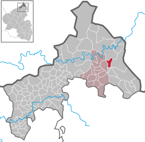
| Location of the local community Grünebach in the district of Altenkirchen (Westerwald) | ||
  |
||


Grünebach is a municipality in the Altenkirchen (Westerwald) district in the northern part of Rhineland-Palatinate . It belongs to the Betzdorf-Gebhardshain community .
geography
Grünebach is located in the northern tip of Rhineland-Palatinate. Located between Betzdorf an der Sieg and Herdorf an der Heller , a tributary of the Sieg , Grünebach belongs to the edge of the Siegerland .
history
The beginning of the settlement in Grünebach cannot be determined in more detail. Among the early Celtic smelting sites of the 6th / 5th century BC In 1952 Heribert and Otto Kipping in Grünebach named three sites around Herdorf / Sieg with "Hohlgrünebach", "Obere Hohlgrünebach" and "Seifen rechts von Hohlgrünebach" (Westfälisches Wirtschaftsarchiv Dortmund, inventory F65 no. 109). In 2012 the floor plans of 2 historic long houses were discovered "on the Müllert", one of which is approx. 60 meters long and 6 meters wide.
Where the name "Grünebach" comes from cannot be clearly clarified either. The opinion, first represented in a commemorative publication by MGV Grünebach and adopted several times by there, that Grünebach was named after the small stream "Hohlgrünebach" (colloquially " Seifen "), which flows into the Heller in Grünebach, cannot be substantiated. In the original cadastre of Grünebach from 1831, the Hohlgrünebach is simply registered as a "Bach" without any name. So the stream was later named after the village and not the other way around. The designation "Grünbach" could possibly indicate an old execution site.
In the Saynian man book the name Gronenbach is mentioned in 1475. In 1576 , the aldermen Michel zu Grünebach was able to persuade the Freusburger count's office to “allow our community to ring the village bell”. The village bell hung on the shepherd's house, which was demolished in 1704. In 1746 the right to ring was set in writing and in 1749 it was recognized and sealed as a bell letter by the Freusburg Office .
The village bell rang in the morning at 6 o'clock, at 12 o'clock for the midday prayer "Angel of the Lord" and in the evening at 6 o'clock and made the people pause. This has shaped the Grünebacher in particular: since 2007, the Grünebach coat of arms has included an oversized village bell as the main component. In 2015, the new bell tower was built over Bendersplatz under the leadership of former mayor Siegfried Eicher.

Grünebach belonged to the county of Sayn-Altenkirchen . Grünebach was also known beyond the region thanks to the new ironworks located on the Hellerbach , in which special iron was produced until the 1960s. In Grünebach, the Heller was dammed so that the water required for iron extraction could be supplied to the hut via the "Hüttengraben". It is assumed that the "new" Grünebacher Hütte was founded after 1607. In 1741 this new hut was sold from a stately property. According to the original cadastre , the Grünebacher Hütte ("ironworks with hammer mill") was owned by Johann Peter Euteneuer († June 20, 1876) & consorts in 1861; Johann Peter Euteneuer's father-in-law, his son and a grandson were each called "Christian". The Grünebach field name "old hut", which is still in existence today and is located on the Daadebach , bears witness to an even older hut tradition. It is believed that the old hut was built before 1478. The Grünebacher Hütte flourished as a producer of specialty iron until shortly after the Second World War . Then the mining and smelting works began in the Siegerland. The Grünebacher Hütte was closed in 1963. The historic blast furnace with rough masonry was placed under monument protection at that time and can still be visited today on the former smelter site.
In the 19th century, the schoolroom and the shepherd's apartment in Grünebach were under one roof. In 1883, the Grünebach pupils were taught alternately on Grünebach and Sassenroth every month. The two classrooms were about 1.5 km apart.
The schoolroom in Grünebach, in which, according to the district school inspector Schwindt, 86 students were taught together with the Sassenroth children on November 27, 1883, was only 35.4 m² in size. (The Sassenrother classroom, where lessons alternated monthly with Grünebach, was at least 44 m².) Because of the cramped conditions and other reasons, a new school was built in Grünebach in 1893.
During the National Socialist era, the cross was also removed from the Grünebach classroom. The students then turned to face the street during the morning prayer, as instructed by the teacher, because there was another cross in a garden on the opposite side of the street. The school cross is said to have been hidden in Haus Weber at the entrance to the village until the end of the war. To this day it hangs in its old place in the former classroom. During the time of National Socialism, Rev. Ignaz Fuhrmann from Betzdorf regularly came to Grünebach on foot in order to give Catholic religious instruction in a private house - religious instruction was forbidden in the school. After the war, Rev. Fuhrmann thanked him in a certificate with the words: “In the most difficult time, when the cross and the Catholic priest were banned from our schools, the Alfons Euteneuer family, Grünebach, offered the children of the Grünebach community a home for them Pastoral care lessons that were held in this room from April 1938 to May 1945. "

The school building is currently used by the volunteer fire brigade , which currently consists of 20 active comrades.
For centuries, the “Hauberge” typical of the Siegerland, with the communal use of the forest, were of great economic importance. The deciduous forest surrounding the place ( Hauberg , mainly consisting of birch, beech and oak) was completely cut down in 23-year cycles for firewood. The parcel was able to regenerate over the course of 23 years. For management purposes, the citizens joined together to form Haubergsgenossenschaften, which still exist today, e.g. B. the "Haubergsgenossenschaft Grünebach / Sassenroth", "Wald", "Imhäuser Hauberg" (on the Weißen Lay) or "Hofberg" (towards Sassenroth). After the logging, the Hauberg colleagues were allowed to sow and harvest grain in the forest areas for a year. In the following years, the germander , which filled the honey pots of the village beekeepers, grew particularly strongly in the clearings .
The ore mining operated in Siegerland was unsuccessful in Grünebach. Several tunnels in the Grünebacher district testify to the unsuccessful efforts to mine iron ore or slate (Siegfried tunnels in Talstrasse).
Until the post-war period was in Grünebach in three places in " Backes bread baked": In the village in Backes on Backespädchen in a Backes at the present cemetery road and in a Backes behind Meyers Werner's house.
You didn't go hungry in war. After the end of the war in 1945 during the American and later French occupation, the old Grünebach people say, there was a shortage of food. During this time young men and women from Grünebach drove to "hamster" food in the Hesse region (e.g. to Treysa near Marburg), where farmers still had reserves.
The Dorfbach Heller has a catchment area of over 200 km², which in turn often meant that the brook could rise sharply and overflow very quickly when it rained continuously. "In the pastures" at the railway underpass is a marking carved in stone of the flood of November 24, 1890, which gives an idea that large parts of the village were flooded at that time. For the old Grünebach people, the flood was worse than a conflagration because of the destruction. Fires could be extinguished, but there was "no herb" against high water.


- Population development
The development of the population of Grünebach, the values from 1871 to 1987 are based on censuses:
|
|
politics
Municipal council
The council in Grünebach consists of twelve council members, who in the local elections on May 26, 2019 in a majority vote were elected, and the honorary mayor as chairman.
mayor
The local mayor of Grünebach is Mike Pfeifer. In the direct election on May 26, 2019, he was re-elected with 92.88% of the vote.
Culture and sights
Local associations
- The oldest Grünebach club is the MGV Grünebach, founded in 1879.
- In 1950, Grünebach journeymen and young men founded the Kolping Family, which is a member of the international Kolping Society . The Jungkolping department was founded in the mid-1970s , and its group work made a significant contribution to youth work in Grünebach. Today 45 Grünebachers are active in the spirit of Adolph Kolping .
- In 1976, the football club 1. FC Grünebach was founded, which was able to secure the championship in the district league C in 2013.
- The “MC Grünebach” motor club was founded in the 1980s and now has over 150 members. In addition to motor sports, various leisure activities are part of the program.
- KFD - women's community. The women organize the women's coffee (formerly: "Mütterkaffee") during the carnival season and perform plays in the autumn.
dialect
An example of the original Grünebacher “Platt” German is the question “Dä dä dat da du?”, Whereby the vowels and umlauts are emphasized very briefly and concisely. As the road traffic increased, the Grünebach children should not go on the "Schussi" (= Chaussee / Straße, emphasis on the "u"). The fact that the Grünebach people appreciate their dialect is shown by the fact that the former main path of the village, the so-called “Fuhrweg”, was officially renamed “Fuhrwääch” in 2016.
Old family names
There are some long-established families in the village who also have house names . So z. B .:
- Bender Rita → house name "Growener Rita";
- Bender Theo → house name "Wiëts Theo";
- Euteneuer Rudolf → house name "Christians Rudolf";
- Fischbach Heinz or Theo → house name "Ströresch Heinz od. Theo";
- Hay buyer Karl → house name "Liss";
- Hay buyer Rudolf → house name "Friedlins Rudolf";
- Imhäuser Theo → House name "Weins Theo";
- Lück Albert → House name "Link"
- Mockenhaupt Ignaz → house name "Waas";
- Schmitt Lothar → house name "Schmiddefritz Lothar";
- ... → House name "Stüwersch"
regional customs
- Easter fire: On Holy Saturday at the beginning of Easter vigil, a large fire is burned "on the Minäu".
- Clatter: from Maundy Thursday to Easter, the village bell does not ring during the Passion. It is said that during this time the bells "flew to Rome". As a substitute, the children and adolescents walk through the village clapping at 7 a.m., 12 p.m. and 6 p.m. in the evening. They go from house to house at noon on Holy Saturday and receive a reward for their service.
- Martin's fire
- Funeral prayer: When a resident of the community dies, citizens meet to pray together for the dead in the community hall in the community center.
Transport and economy
Road traffic
The community can be reached via the A 45 and the B 62.
Rail transport
The Grünebach Ort train stop is located in the municipality, where trains on the Hellertalbahn (Betzdorf - Herdorf - Haiger - Dillenburg ) line run every hour under the line number RB 96 according to the Rhineland-Palatinate cycle .
At Betzdorf (Sieg) train station, there are travel options in the direction of Cologne and Siegen, using the Rhein-Sieg-Express (RSX), which runs as RE 9 from Aachen via Düren, Cologne, Siegburg / Bonn, Au (Sieg) and Wissen to Siegen and to the RB 95, which commutes between Au (Sieg), Wissen and Siegen.
Traffic history
At the end of the last century, a rambling road was to be built through the Grünebach district as a bypass for the city of Betzdorf. In order to make a decision regarding the route, a detailed model was made around 1980, the quality of which was so high that it can be seen today in the German Road Museum in Germersheim / Rhine. The bypass was ultimately not built for nature and environmental reasons, including the occurrence of the hazel grouse and a bluish butterfly that is protected throughout Europe.
Personalities
- Franz Bender, landlord with horse and cart and Grünebacher "Original". He did not shy away from addressing the district administrator, who visited his inn, with "you". The largest square in Grünebach, "Benders Platz", is popularly named after him. His son Hans ran an inn on site until 2014.
Sons and daughters of the church
- Édouard Baldus (1813–1889), German-French architectural photographer
- Gerlach Ermert (born September 20, 1657 in Grünebach, † December 18, 1716 in Grünebach, buried in Kirchen), in 1686 in Trier as Catholic. Ordained priest, imperial notary and theologian.
Gerlach Ermert was born as one of four children to the married couple Anton and Veronica Ermert. The Grünebach line of the Ermert clan was wealthy. Anton Ermert was able to provide his son Gerlach with "complete housekeeping, twelve loaded carts of movables, a horse, ten head of cattle, a pig, fruit, books and a fair amount of cash". (see E. Vierbuchen, Heimatjahrbuch Kreis Altenkirchen 1981, p. 293)
literature
- Benno Solbach: The Grünebacher bell letter. A 240 year old document regulates the ringing of the village bell. In: Siegerland 1992 (volume 69) issue 1–2, p. 49.
- Peter Lindlein: The Secret of Eduard Baldus. A boy from Grünebach . ( lindlein.com [PDF; accessed December 20, 2017]).
- Erich Vierbuchen: Gerlach Ermert from Grünebach, imperial notary and theologian (around 1655–1716). In the Heimat-Jahrbuch des Kreis Altenkirchen 1981, pp. 293–298.
- Altolpe: Pastor Gerlach Ermert . S. 151–176 ( altolpe.de [PDF; accessed December 20, 2017]).
Web links
Individual evidence
- ↑ a b State Statistical Office of Rhineland-Palatinate - population status 2019, districts, municipalities, association communities ( help on this ).
- ↑ State Statistical Office Rhineland-Palatinate - regional data
- ^ The Regional Returning Officer for Rhineland-Palatinate: City Council Election 2019 Grünebach. Retrieved November 15, 2019 .
- ^ The State Returning Officer Rhineland-Palatinate: direct elections 2019. see Betzdorf-Gebhardshain, Verbandsgemeinde, ninth line of results. Retrieved November 15, 2019 .

Almersbach | Alsdorf | Altenkirchen (Westerwald) (city, seat of the district administration) | Bachenberg | Berod near Hachenburg | Berzhausen | Betzdorf (city) | Birch honey meal | Birch bump | Birnbach | Bitches | Brachbach | Breitscheidt | Bruchertseifen | Bürdenbach | Burglahr | Busenhausen | Daaden (city) | That | Dickendorf | Eichelhardt | Oak trees | Elves | Elkenroth | Emmerzhausen | Ersfeld | Etzbach | Eulenberg | Fensdorf | Fiersbach | Flammersfeld | Floodlight | Forest | Forstmehren | Friedewald | Friesenhagen | Fürthen | Gebhardshain | Gieleroth | Giershausen | Grünebach | Güllesheim | Hamm (victory) | Harbach | Hasselbach | Helmenzen | Helmeroth | Hemmelzen | Herdorf (city) | Haylofts | Hilgenroth | Hirz-Maulsbach | Horhausen (Westerwald) | Hövels | Idelberg | Ingelbach | Isert | Katzwinkel (victory) | Chew | Kescheid | Kettenhausen | Churchib | Churches (victory) (city) | Kraam | Krunkel | Malberg | Mammelzen | Mauden | More | Michelbach (Westerwald) | Mittelhof | Molzhain | Mudersbach | Nauroth | Neitersen | Niederdreisbach | Niederfischbach | Niederirsen | Niedersteinebach | Nisterberg | Obererbach (Westerwald) | Oberirsen | Oberlahr | Obernau | Obersteinebach | Oberwambach | Oils | Orfgen | Peterslahr | Pleckhausen | Splendor | Racksen | Reiferscheid | Rescuers | Rosenheim (District of Altenkirchen) | Roth | Rott | Scheuerfeld | Schöneberg | Stokes | Schutzbach | Seelbach (Westerwald) | Seelbach near Hamm (victory) | Soaps | Selbach (victory) | Sörth | Steinebach / Victory | Steineroth | Stürzelbach | Volkerzen | Wallmenroth | Walterschen | Weitefeld | Werkhausen | Weyerbusch | Willroth | Knowledge (city) | Wölmersen | Goat grove