Katzwinkel (victory)
| coat of arms | Germany map | |
|---|---|---|

|
Coordinates: 50 ° 49 ' N , 7 ° 49' E |
|
| Basic data | ||
| State : | Rhineland-Palatinate | |
| County : | Altenkirchen (Westerwald) | |
| Association municipality : | Knowledge | |
| Height : | 287 m above sea level NHN | |
| Area : | 15.8 km 2 | |
| Residents: | 1776 (Dec. 31, 2019) | |
| Population density : | 112 inhabitants per km 2 | |
| Postal code : | 57581 | |
| Primaries : | 02741, 02742 | |
| License plate : | AK | |
| Community key : | 07 1 32 080 | |
| Association administration address: | Rathausstrasse 75 57537 Knowledge |
|
| Website : | ||
| Local Mayor : | Hubert Becher ( CDU ) | |
| Location of the local community Katzwinkel (Sieg) in the district of Altenkirchen (Westerwald) | ||
Katzwinkel (Sieg) is a municipality in the Altenkirchen (Westerwald) district in Rhineland-Palatinate . She belongs to the Verbandsgemeinde Wissen .
geography
Geographical location
Katzwinkel is located in the transition area of the Northern Westerwald / Bergisches Land / Siegerland - in the so-called Wildenburger Land , the name of which is derived from Wildenburg Castle .
Neighboring communities
Neighboring places are churches (Sieg) , Betzdorf , Wissen (Sieg) , Friesenhagen and Birken-Honey Essen .
structure
Districts of Katzwinkel are Elkhausen, Hönningen, Schönborn, Nochen, Alsenthal, Ebertseifen, Nimroth and a few farms.
history
The first reliable mention of the place can be found in the archives of the princes of Hatzfeld -Wildenburg zu Schönstein an der Sieg under Regest No. 675 from February 14, 1493, where a Peter Katzwinkel is mentioned as a lay judge . Under the regest no. 801 of 1505, an appeal from Katzwinkel is enfeoffed with land and farm in the district; further mentions of farms from 1505 exist. Elkhausen, on the other hand, was only settled with one farm for a long time. In 1557 a Johann von Elkhausen (Elkhuisen) is enfeoffed.
The development of Katzwinkel and Elkhausen from Höfen to the village began around 1750. In the vicinity of Katzwinkel, a number of mine fields were opened in the years around 1750–1770, some of which are still visible today. In 1824 ore mining in the tunnel mining began in the Katzwinkel area. In 1836 the mine field "Die Vereinigung " was formed by merging , which worked to a depth of 1023 m and was closed in 1963.
Hamlets and farms
The "Topographical-Statistical Description of the Royal Prussian Rhine Province" from 1830 describes the municipality of Nochen (today Katzwinkel) as follows:
- "The municipality of Nochen with 479 inhabitants consists of the hamlets, courtyards, houses and mills: Alteweyer, Bornhahn, Bracht, Buchen, Büschen, Bohmberg, Ebertsseiffen, Euelen, Fähringen, Halsenthal, Hassel, Hellkausen, Hönningen, Hecken, Kalteiche, Katzwinkel, Linden, Mäuswinkel, Neurohm, Oetgesborn, Porzhardt, Reiffenrath, Scheuren, Schönborn, Steeg, Stockschladen and Völzen ”.
Name change
On July 1, 1970, the community was renamed from "Nochen" to "Katzwinkel (Sieg)".
Population development
The development of the population of Katzwinkel (Sieg), the values from 1939 to 1987 are based on censuses:
|
|
politics
Municipal council
The local council in Katzwinkel consists of 16 council members, who were elected in the local elections on May 26, 2019 in a personalized proportional representation, and the honorary local mayor as chairman.
The distribution of seats in the municipal council:
| choice | SPD | CDU | FWG | BfKE | total |
|---|---|---|---|---|---|
| 2019 | - | 10 | - | 6th | 16 seats |
| 2014 | 6th | 10 | - | - | 16 seats |
| 2009 | 5 | 9 | 2 | - | 16 seats |
| 2004 | 5 | 9 | 2 | - | 16 seats |
- FWG = Free Voting Group Verbandsgemeinde Wissen e. V.
- BfKE = Citizens for Katzwinkel-Elkhausen e. V.
mayor
The local mayor of Katzwinkel is Hubert Becher (CDU). In the direct election on May 26, 2019, he was elected with 82.50% of the vote and is thus the successor to Wolfgang Würden (CDU), who did not run again.
coat of arms
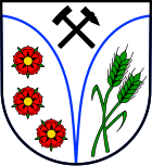
| Blazon : “In silver split by a blue tip bent in from the head of the shield, covered with a bent silver tip, this covered with crossed black mining symbols, mallets and iron, in front three red five-petalled heraldic roses with green sepals and golden lugs [...], behind two green ears of corn. " | |
| Justification for the coat of arms: The blue dividing lines stand for the two streams of the place (the Brölbach von Katzwinkel and the Hüttenbach von Elkhausen), which later unite (as should also be pointed out to the union of the places Elkhausen and Katzwinkel). Mallets and irons symbolize the mining past. The three roses are from the coat of arms of the free imperial rule Wildenburg , which was formerly sovereign in parts of the district. The ears of wheat symbolize the agricultural past, the color green stands for the abundant forest areas. |
Parish partnership
The local community of Katzwinkel (Sieg) has maintained an intra-German community partnership with the community of Kefferhausen in the Eichsfeld district in Thuringia since 1994 .
Culture and sights
Churches
The place has three churches: the Catholic parish church St. Bonifatius in Elkhausen and its branch church St. Barbara in Katzwinkel as well as the Protestant church located in the district Katzwinkel.
Regular events
Important festivals are the Schützenfest (Pentecost), the Garagos Bazaar (every first Sunday in September) and the Bazaar football tournament (which bring in donations in the four to five-figure range for the mission of the Comboni sisters in Egypt), the bazaar of KFD, the parish festival and numerous other events to maintain the youth home as well as events of the many associations. In addition, there are regular discos and benefit concerts by the local band Splash , which collects money for the Olpe children's hospice.
Cultural monuments
List of cultural monuments in Katzwinkel (Sieg)
Economy and Infrastructure
The place is a former mining village and had one of the largest ore mines in Siegerland ( Grube Vereinigung ). After its closure in the 1960s, the transformation of the village, which is mainly geared towards mining, went very well. A small sports airfield with a grass runway (approx. 500 m) is located in Wingendorf. This is the Betzdorf-Kirchen airfield .
economy
A number of industrial and craft companies have settled in Katzwinkel, some of which have a significant export share: Secatec (sensors, electronics), SB SCHWEISSTECHNIK (welding machines), InventAir air and heating technology (extraction and process heating systems) as well as various other commercial, retail and Logistics companies. There is a renowned holiday and recreation home and three restaurants in the village. 18 farms cultivate around 500 hectares of arable and pasture land.
Public facilities
On site there is a primary school, the St. Barbara primary school, and the Löwenzahn kindergarten, as well as a multi-purpose hall and a youth center.
Web links
Individual evidence
- ↑ State Statistical Office of Rhineland-Palatinate - population status 2019, districts, communities, association communities ( help on this ).
- ↑ Friedrich von Restorff : Topographical-Statistical Description of the Royal Prussian Rhine Province , Nicolai, Berlin and Stettin 1830, page 702
- ↑ Official municipality directory (= State Statistical Office of Rhineland-Palatinate [Hrsg.]: Statistical volumes . Volume 407 ). Bad Ems February 2016, p. 187 (PDF; 2.8 MB).
- ↑ State Statistical Office Rhineland-Palatinate - regional data
- ^ The Regional Returning Officer Rhineland-Palatinate: Municipal Council Election 2019 Katzwinkel. Retrieved November 10, 2019 .
- ↑ Local election Rhineland-Palatinate 2014, municipal council
- ^ The State Returning Officer Rhineland-Palatinate: direct elections 2019. see Knowledge, Verbandsgemeinde, fourth line of results. Retrieved November 10, 2019 .


