Central courtyard
| coat of arms | Germany map | |
|---|---|---|

|
Coordinates: 50 ° 47 ' N , 7 ° 48' E |
|
| Basic data | ||
| State : | Rhineland-Palatinate | |
| County : | Altenkirchen (Westerwald) | |
| Association municipality : | Knowledge | |
| Height : | 256 m above sea level NHN | |
| Area : | 11.13 km 2 | |
| Residents: | 993 (Dec. 31, 2019) | |
| Population density : | 89 inhabitants per km 2 | |
| Postal code : | 57537 | |
| Area code : | 02742 | |
| License plate : | AK | |
| Community key : | 07 1 32 011 | |
| Community structure: | 22 districts | |
| Association administration address: | Rathausstrasse 75 57537 Knowledge |
|
| Website : | ||
| Local Mayor : | Franz Cordes | |
| Location of the local community Mittelhof in the district of Altenkirchen (Westerwald) | ||
Mittelhof is a municipality in the Altenkirchen (Westerwald) district in Rhineland-Palatinate . She belongs to the Verbandsgemeinde Wissen .
geography
Geographical location
The community lies between Betzdorf and Wissen .
Community structure
Overall, the community of Mittelhof is divided into 22 districts and residential areas :
- Blickhausen
- Blickhauser forest
- Grave
- Courtyard floodplains
- Hüngesberg
- Katzenthal
- Clover
- Kohlschlade
- Middle Durwittgen
- Central courtyard
- Neuröttgen
- Niederdurwittgen
- Niederkrombach
- Oberdurwittgen
- Oberkrombach
- Osenbach
- Quadenhof
- Roddern
- Röttgen
- Steckenstein
- Devil's Break
- Vosswinkel
history
Mining
In the middle of the 19th century, the community Blickhauserhöhe (former name for Mittelhof) owned three mining operations , in which iron and copper ore were extracted. Due to the constantly growing demand for ores and the associated demand for workers, the population grew rapidly at this time.
By 1892, however, two pits had been closed, causing greater unemployment in Mittelhof. However, this unemployment was curbed by the third mine, which was very ore-rich. At the beginning of the 20th century this mine was even considered to be one of the most technically developed mining operations and Mittelhof continued to grow in population.
The last mine was closed in February 1964, as mining at depths of over 1,000 m became too expensive and unprofitable. The Mittelhofer church with its Barbara window reminds of the former mining industry.
Blickhauserhöhe community
The "Topographical-Statistical Description of the Royal Prussian Rhine Provinces" from 1830 describes the community Blickhauserhöhe (today Mittelhof) as follows:
“The community Blickhauserhöhe with 297 inhabitants. These include: the hamlets of Hüngesberg with 25, Voswinkel with 24, Ober-Krombach with 33, Röttgen with 30, the Höfe Nieder-Krombach with 9, Aue with 9, Eichen with 11, Katzenthal with 11, Blickhausen with 12, Karnweg with 4 , Ouadenhof with 15, Mittelhof with 18, Ossenbach with 10, Roddern with 15, Steckenstein with 14, Kohlschladen with 9, Nieder-Dorwittgen with 11, Mittel-Dorwittgen with 18, Ober-Dorwittgen with 20 inhabitants. "
Name change
On March 1, 1986, the community was renamed from "Blickhauserhöhe" to "Mittelhof".
Population development
The development of the population of Mittelhof, the values from 1871 to 1987 are based on censuses:
|
|
politics
Municipal council
The local council in Mittelhof consists of twelve council members, who were elected in a personalized proportional representation in the local elections on May 26, 2019 , and the honorary local mayor as chairman. By the 2019 election, there were 16 council members.
The distribution of seats in the municipal council:
| choice | SPD | CDU | FWG | WGR | total |
|---|---|---|---|---|---|
| 2019 | - | - | 7th | 5 | 12 seats |
| 2014 | - | - | 10 | 6th | 16 seats |
| 2009 | 3 | 7th | 6th | - | 16 seats |
| 2004 | 3 | 7th | 6th | - | 16 seats |
- FWG = Free Voting Group Mittelhof-Hövels e. V.
- WGR = voter group Reifenrath e. V.
mayor
The local mayor of Mittelhof is Franz Cordes. In the direct election on May 26, 2019, he was re-elected with 78.70% of the vote.
coat of arms
|
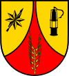
Blazon : "In the right field a black compass rose with a black arrow drawn from the southwest to the northeast on a gold background, in the large central field a golden ear of corn on a red background, in the left field a black miner's lamp on a gold background."
The municipality has had this coat of arms since October 7, 1986. |
|
Local partnership
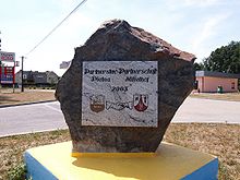
Since August 2002 Mittelhof has maintained a partnership with the village of Pietna ( Krapkowice municipality ) in Poland . The partnership, which was officially confirmed on May 30, 2003, came about on the initiative of the residents of Pietna, who sought a partnership with a German community. Since the city of Krapkowice has already had a long partnership with the city of Wissen , a community in the Wissen association was looked for and a partner was finally found in Mittelhof.
economy
After the last ore mines were closed in 1954 and 1964, tourism in Mittelhof has increased significantly since the late 1960s and is now a determining factor in economic life. Restaurants, private pensions, camping sites and mobile home parks offer plenty of accommodation and vacation options.
Lebenshilfe for the mentally handicapped e. V.
“In the spring of 1962, several parents of mentally handicapped children founded a local association of Lebenshilfe e. V. , which has always seen it as its task to promote measures and facilities that provide effective life support for the mentally handicapped of all ages. Since 1971, the association has had a domicile in the former Grube “Friedrich” leisure center in the community of Mittelhof. […] Around 170 jobs are available to the disabled today. [...] On the occasion of the 25th anniversary of Lebenshilfe, a new residential building was opened in 1987. 29 disabled people have now found a new home here. "
Attractions
- The neo-Gothic church “St. Marien “(1895-1997);
- the oldest youth home in the Altenkirchen district (1929–1931);
- the listed half-timbered house "Quadenhof" from the 15th century (restored in 1987).
See also:
Sons and daughters
- Alois Brendebach (1896–1991), politician (center), member of the Oldenburg state parliament
Web links
Individual evidence
- ↑ State Statistical Office of Rhineland-Palatinate - population status 2019, districts, communities, association communities ( help on this ).
- ↑ State Statistical Office Rhineland-Palatinate (ed.): Official directory of the municipalities and parts of the municipality. Status: January 2019 [ Version 2020 is available. ] . S. 17 (PDF; 3 MB).
- ^ Friedrich von Restorff: Topographical-Statistical Description of the Royal Prussian Rhine Provinces , 1830, p. 702.
- ↑ Official municipality directory (= State Statistical Office of Rhineland-Palatinate [Hrsg.]: Statistical volumes . Volume 407 ). Bad Ems February 2016, p. 186 (PDF; 2.8 MB).
- ↑ State Statistical Office Rhineland-Palatinate - regional data
- ↑ The Regional Returning Officer Rhineland-Palatinate: City Council Election 2019 Mittelhof. Retrieved November 10, 2019 .
- ^ The Regional Returning Officer Rhineland-Palatinate: Municipal elections 2014, city and municipal council elections
- ^ The State Returning Officer Rhineland-Palatinate: direct elections 2019. see Knowledge, Verbandsgemeinde, second line of results. Retrieved November 10, 2019 .
- ^ Homepage of the community ( Memento of October 30, 2004 in the Internet Archive )


