
Agger
| Agger | ||
 Muzzle of the Sülz (below) into the Agger |
||
| Data | ||
| Water code | EN : 2728 | |
| location | Germany | |
| River system | Rhine | |
| Drain over | Victory → Rhine → North Sea | |
| source | south of Meinerzhagen 51 ° 5 ′ 56 ″ N , 7 ° 39 ′ 5 ″ E |
|
| Source height | 438 m above sea level NHN | |
| muzzle | near Troisdorf in the Sieg Coordinates: 50 ° 48 '2 " N , 7 ° 10' 27" E 50 ° 48 '2 " N , 7 ° 10' 27" E |
|
| Mouth height | 51 m above sea level NHN | |
| Height difference | 387 m | |
| Bottom slope | 5.6 ‰ | |
| length | 69.5 km | |
| Catchment area | 816.244 km² | |
| Discharge at the Lohmar A Eo gauge : 785 km² Location: 5.62 km above the mouth |
NNQ (07/29/1957) MNQ 1951/2007 MQ 1951/2007 Mq 1951/2007 MHQ 1951/2007 HHQ (02/23/1970) |
834 l / s 2.31 m³ / s 17.1 m³ / s 21.8 l / (s km²) 189 m³ / s 385 m³ / s |
| Reservoirs flowed through | Aggertalsperre | |
| Medium-sized cities | Meinerzhagen , Gummersbach , Overath , Lohmar , Siegburg , Troisdorf | |
| Small towns | Bergneustadt | |
| Communities | Lindlar , Engelskirchen | |
The Agger is a 69.5 km long, north-eastern and right tributary of the Sieg in southern North Rhine-Westphalia . It flows in the Märkischer Kreis , Oberbergischer Kreis , Rheinisch-Bergischer Kreis and Rhein-Sieg-Kreis .
Origin of name
The name Agger is of Celtic origin from pre-Germanic times and means "flowing water". The root of the word is the same as, for example, in Latin “aqua”.
geography
course
The source of the Agger is located on the southern outskirts of Meinerzhagen at 437 m above sea level. NHN and one kilometer west of the Volme spring . From here it first flows south, taking in several small streams on the right and left sides. The Leienbach, coming from the east, flows out shortly after Grünenthal . A few kilometers further, the Agger reaches the Aggertalsperre, named after it . The Rengse , which comes from the east, and the Genkel , which also comes from the north, flow here, which are dammed up to the Genkeltalsperre just a few kilometers before they flow into the Aggertalsperre .
After leaving the Aggertalsperre, the Agger flows near Dümmlinghausen , here lined on the left by an embankment of the dismantled Gummersbacher Kleinbahnen , in a wide arc to the west around the Aehlenberg ( 380.9 m ), takes up the Hesselbach on the right and the Leienbach on the left and reaches a little later Shock . Here the Dörspe coming from the northeast from Bergneustadt and the Steinagger coming from the south meet . The Agger turns its course to the west, flows through Rebbelroth and takes in the Seßmarbach flowing in from the north near Niederseßmar . The Rospebach and Strombach and the Halstenbach, which comes from the southeast, also flow from the north at Vollmerhausen .
The Loper Bach coming from the north flows near Oesinghausen , which shortly before had taken up the longer Lambach . The Wiehl flowing in from the south flows between Osberghausen and Ründeroth . The Walbach flowing to the right has an underground mouth in Ründeroth and, a little downhill from the Agger, an above-ground mouth opposite the locality of Ohl. In the Engelskirchen area , the Kaltenbach flows first on the left , then the Leppe and Horpebach on the right . At Loope , the Agger takes on the Loopebach coming from the east and the Holzerne Siefen coming from the north .
Behind Loope, the Agger flows to the southwest. After the Ehreshoven reservoir , the Schlingenbach and the Lombach, coming from the southeast, flow . A little later, the Agger Overath flows around to take in the Bombach and Dahlhauser Bach coming from the northwest a few kilometers further . The further route leads the Agger past the Lohmar districts of Agger , Honsbach , Neuhonrath and Wahlscheid . In Honsbach, the Agger flows to the left of the Honsbach coming from the east. In Neuhonrath, the Maarbach, also coming from the east, flows to the left of the Agger. In Wahlscheid the Steffensbach first flows into the Aggerbogen from the right bank, then three more nameless streams follow, also from the right bank. After the wooden bridge at Schiffarther Straße, the Hohner Bach flows from the left bank of the Agger. Shortly afterwards the Oberscheider Bach flows from the right to the Agger. At the southern end of Wahlscheid, the Kirchbach , Mackenbach , Atzenbach and Stolzenbach finally flow into the Agger from the left bank . Before Donrath in Kreuznaaf , the Naafbach flowing in from the east is recorded. In Donrath the Ellhauser Bach and the Hasselsiefen flow into the Agger on the left. The Sülz from the north and the Jabach from the east flow between Donrath and Lohmar . At Lohmar , the Scheuerbach coming from the northwest and the Auelsbach flowing through Lohmar flow on the left. A little later the Agger flows into the Sieg between Troisdorf in the west and Siegburg in the east .
On its way from the source to the mouth, the Agger experiences a height difference of 386 m with an average bed gradient of 5.6 ‰.
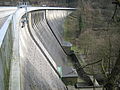
Aggertalsperre near Hackenberg

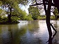
The Agger in Lohmar

Aggerwehr in Troisdorf
Mouth of the Agger in the Sieg (from the back left)

The agger in loop


Tributaries
The largest tributary of the Agger is the Sülz at river kilometers 7.1. With its 244.571 km² catchment area it has a share of 30% in that of the Agger. Another important tributary is the Wiehl , which is 33.6 km longer than the Agger with 27.7 km up to this point. However, at this point the Agger has the larger catchment area with 180.592 km² compared to the Wiehl with 140.721 km². In the following, the tributaries of the Agger are named that are longer than 5 km or have a catchment area of more than 5 km². They are named in the order from the source to the mouth.
| Surname |
Stat. in km
|
location | Length in km |
EZG in km² |
Mouth height in m above sea level NHN |
GKZ |
|---|---|---|---|---|---|---|
| Rengse | 61.463 | Left | 5.630 | 7.475 | 284 | 2728 12 |
| Genkel | 60.890 | right | 7.102 | 10.656 | 284 | 2728 14 |
| Dörspe | 56.035 | Left | 11.747 | 27.633 | 202 | 2728 18 |
| Stone excavator | 55.830 | Left | 11,424 | 30,343 | 201 | 2728 2 |
| Seßmarbach | 51,481 | right | 9,036 | 20,182 | 181 | 2728 32 |
| Rospebach | 48.779 | right | 8.194 | 13.279 | 169 | 2728 34 |
| Strombach | 48,548 | right | 8.313 | 6.390 | 169 | 2728 36 |
| Loper Bach | 43.766 | right | 3.068 | 10.017 | 153 | 2728 38 |
| Wiehl | 41.779 | Left | 33,594 | 140.721 | 145 | 2728 4 |
| Walbach | 38.284 | right | 5.057 | 6.581 | 132 | 2728 52 |
| Kaltenbach | 36.227 | Left | 5.356 | 5.756 | 126 | 2728 54 |
| Leppe | 33.811 | right | 19,392 | 52.227 | 119 | 2728 6 |
| Loopebach | 30,589 | Left | 7.697 | 12,528 | 111 | 2728 72 |
| Schlingenbach | 25.884 | Left | 6.613 | 8,731 | 99 | 2728 74 |
| Naafbach | 9.963 | Left | 22.652 | 45.869 | 67 | 2728 78 |
| Sülz | 7.102 | right | 48.711 | 244,571 | 62 | 2728 8 |
| Yeah | 6,901 | Left | 7.809 | 7.523 | 61 | 2728 92 |
| Auelsbach | 5.412 | Left | 7.417 | 7.720 | 59 | 2728 94 |
| Rothenbach | 2.806 | Left | 5.672 | 56 | 2728 994 |
Localities
- Meinerzhagen (source)
- Lantenbach
- Leienbach
- Dümmlinghausen
- The punch
- Rebbelroth
- Lower Saxony
- Vollmerhausen
- Dieringhausen
- Osberghausen
- Wiehlmünden
- Ründeroth
- Engelskirchen
- Loop
- Remshagen
- Vellingen
- Hohkeppel
- Vilkerath
- Overath
- Agger
- Neuhonrath
- Voting
- Donrath
- Altenrath
- Lohmar
- Troisdorf / Siegburg (estuary) opposite Sankt Augustin
Conservation and renaturation
The Aggerauen and a narrow strip along the bank from Vilkerath to almost the mouth form the FFH area Agger . Among other things, attempts are being made to reintroduce salmon in the Agger .
In Lohmar-Wahlscheid the Agger flows through the landscape garden of Aggerbogen . There, the city of Lohmar, the state of North Rhine-Westphalia and the Naturschutzbund Deutschland (Nabu) renaturalized the Aggerufer region. The Aggerbogen landscape garden is also the location of the Aggerbogen nature school , where nature and environmental protection are explained to children and adults.
Agger association
The Aggerverband (based in Gummersbach ) takes care of the maintenance of the rivers in the above-mentioned area, flood protection, purification of wastewater as well as drinking water treatment and supply.
Weather events
In January 2009 the Agger was completely covered with a 5 to 10 cm thick layer of ice in places with outdoor temperatures of −17 ° C and colder for several days, for example on the river sections of the Agger in Lohmar - Wahlscheid , such as the Aggerbogen. The bank zones were almost completely covered with a strip of ice at least one meter wide. Ice floes could be seen floating from the bridges over the Agger .
history
On January 2, 1584, the Battle of the Agger took place on the lower Agger during the Truchsessian War .
traffic
In addition to some roads, the Aggertalbahn railway line , which runs almost parallel in many places, is named after the Agger . Until the 1950s, the line of the Gummersbacher Kleinbahnen ran parallel in Dümmlinghausen , whose embankment can still be seen today between the roundabout towards Bernberg / Derschlag and the first bend in Aggertalstrasse.
Web links
- Aggerverband , on aggerverband.de
- Swimming in and canoeing on Sieg and Agger , on rhein-sieg-kreis.de
- Agger , on openstreetmap.org
Individual evidence
- ↑ a b German basic map (DGK 5) in Topographical Information Management, Cologne District Government, Department GEObasis NRW ( information )
- ↑ a b c Topographical Information Management, Cologne District Government, Department GEObasis NRW ( information )
- ^ German hydrological yearbook Sieg / Lohmar 2007 ( Memento from June 4, 2015 in the Internet Archive ) (PDF; 24 kB)
- ↑ Manuela Giannetti: Nature school in the Aggerbogen. lohmar.de, accessed on August 22, 2015 .
- ↑ Lohmar. Live actively in the country. Aggerbogen Nature School. naturschule-aggerbogen.de, accessed on August 22, 2015 .