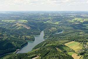
Genkeltalsperre
| Genkeltalsperre | |||||||
|---|---|---|---|---|---|---|---|
| Dam and dam | |||||||
|
|||||||
|
|
|||||||
| Coordinates | 51 ° 3 '45 " N , 7 ° 37' 47" E | ||||||
| Data on the structure | |||||||
| Construction time: | 1950-1952 | ||||||
| Height above valley floor: | 41 m | ||||||
| Height above foundation level : | 44 m | ||||||
| Height of the structure crown: | 330.40 m | ||||||
| Building volume: | 380,000 m³ | ||||||
| Crown length: | 200 m | ||||||
| Crown width: | 7.80 m | ||||||
| Base width: | 164 m | ||||||
| Slope slope on the air side : | 1: 1.50 / 1: 1.65 | ||||||
| Slope slope on the water side : | 1: 2.12 | ||||||
| Data on the reservoir | |||||||
| Altitude (at congestion destination ) | 327.50 m | ||||||
| Water surface | 64 ha | ||||||
| Reservoir length | 2.8 km | ||||||
| Reservoir width | 100 - 200 m | ||||||
| Storage space | 8.2 million m³ | ||||||
| Total storage space : | 8.5 million m³ | ||||||
| Catchment area | 11.5 km² +3.5 km² through transition | ||||||
| Design flood : | 22 m³ / s | ||||||
The Genkeltalsperre is a pure drinking water dam and is located in the urban areas of Gummersbach and Meinerzhagen . It is mainly fed by the Genkel and Grotmicke rivers . The mean annual precipitation in the catchment area is 1320 mm, which ensures an annual inflow of approx. 10 million m³. Most households in the area can be supplied with drinking water from the Genkeltalsperre. It was built in 1950–53.
The dam
The dam of the Genkeltalsperre consists of a rock fill without mortar. On the water side, it is waterproofed with a double asphalt concrete cover. On the air side , the embankment was landscaped with groups of lawns and shrubs. The height of the dam is 41 m above the valley floor, its crown length is 200 m and the crown width is 7.8 m. The stowage volume is 8.2 million cubic meters.
Recreation
The Genkeltalsperre offers two circular hiking trails, 10 km and 14 km long. They are well secured and offer opportunities for cycling, jogging and hiking. In addition, a richly signposted nature trail was laid out in 2003 around the Genkeltalsperre. For reasons of water protection , however, the dam and direct bank areas are cordoned off and inaccessible. Bathing and camping are prohibited, including fishing without a permit. The picturesque old manor Gut Listringhausen is located near the front basin of the dam .
Protected areas
The north-western tip of the Genkeltalsperre with the inlet of the Genkel brook into the lake is part of the Genkel Valley nature reserve . The Grotmicke nature reserve extends to the banks of the northeastern tip of the dam.
See also
literature
- Peter Franke, Wolfgang Frey: Dams in the Federal Republic of Germany. Published by the National Committee for Large Dams in the Federal Republic of Germany (DNK) and the German Association for Water Management and Cultural Building eV (DVWK). Systemdruck-GmbH, Berlin 1987, ISBN 3-926520-00-0 .
Web links
- Dams directory NRW (PDF; 122 kB)
- Dams in North Rhine-Westphalia; State Environment Agency NRW (PDF; 124 kB)

