
Niederseßmar
|
Niederseßmar
City of Gummersbach
Coordinates: 51 ° 0 ′ 17 ″ N , 7 ° 34 ′ 21 ″ E
|
||
|---|---|---|
| Height : | 189 (180-275) m above sea level NN | |
| Residents : | 3117 (Jun. 30, 2016) | |
| Postal code : | 51645 | |
| Area code : | 02261 | |
Location of Niederseßmar in Gummersbach |
||
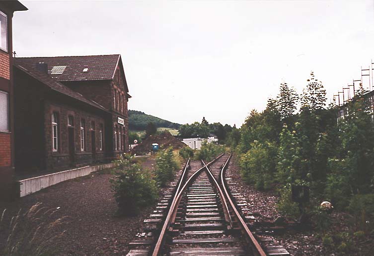
 Partial view of the place
|
||


Niederseßmar is a district of the city of Gummersbach in the Oberbergisches Kreis in southern North Rhine-Westphalia .
geography
Niederseßmar extends from the confluence of the Seßmarbach and the Agger along both river valleys and on the slopes of the surrounding mountain ranges, especially the Karhelle (334 m above sea level).
The place is located approx. 3.8 km from the city center at the confluence of the L 323 (Gummersbach - Meinerzhagen ) in the federal highway 55 and thus at a heavily frequented traffic junction, the so-called "triangle".
Neighboring Gummersbach districts are Rospe in the north, Rebbelroth in the east, Remmelsohl (south-south-west), Vollmerhausen in the south-west and Mühle in the west. The formerly independent districts of Ahlefeld (west-southwest) and Friedrichsthal (south-southwest) are now officially counted as Niederseßmar.
history
Local history
Niederseßmar was first mentioned in a document in 1447 when the place name neder Seßmar was used in the invoices of Homburg rent master Johann van Flamersfelt . The settlement appears as Nider Tzissemer on the Mercator map of 1575 .
In the past, Niederseßmar was a border town in several respects. In the Middle Ages, the territories of the Counts of Berg , Mark and Sayn touched on the "Dreiherrenstein" . Around 1800 the border between the farming communities Bernberg (north of the Agger) and Rospe (west of the Agger) ran through the town .
The village of Niederseßmar belonged to the imperial rule of Gimborn-Neustadt until 1806 . After belonging to the Grand Duchy of Berg (1806-1813) and a provisional transitional administration , the region came to the Kingdom of Prussia in 1815 on the basis of the agreements made at the Congress of Vienna . Under the Prussian administration, the place first belonged to the Gimborn district (1816–1825) and then to the Gummersbach district in the Rhine Province . In 1843 the village had 124 inhabitants, most of whom were Protestant, and 25 houses.
Traffic history
The place's role as a traffic junction began in 1820, when the section of the country road from Elberfeld to Siegen that ended here was completed - the first art road in the old district. In 1823 the construction of a Prussian state road from Cologne to Olpe (today's B 55) began. Niederseßmar was now at the crossroads of the two most important traffic routes in the region. With the start of the express mail Cologne – Olpe – Siegen, the place became a boarding station for the Gummersbach area; In 1861 21 stagecoaches stopped in Niederseßmar every week.
The town reached a high point in traffic development in 1886 with the opening of the "Gummersbach Railway Station" on the Siegburg – Olpe railway line . The station got its name "Niederseßmar" with the opening of the Volmetalbahn to Marienheide line, which is still preserved today . In 1979 passenger traffic was stopped in the Dieringhausen –Olpe section , and in 1997 goods traffic was also discontinued, which meant that the station became inoperative. In the area of Niederseßmar there are only remnants of the route, z. B. is now cutting through an American fast food restaurant that has been trackless since 2013. The station building still exists.
Industrial history
In 1751 a Reckhammer powered by the Seßmarbach was built ; Before 1800 there was also an ironworks at the confluence with the Agger . The textile industry flourished in Niederseßmar primarily in the second half of the 19th century: In 1861 Friedrich Wilhelm Sondermann founded a wool spinning mill and in 1871 Carl Huland and his business partner opened the wool spinning mill Huland & Heuser. A wool factory, a mechanical weaving mill and several synthetic wool factories were established . The first steam locomotive in Oberbergisches was also set up here by Friedrich Wilhelm Sondermann. None of the mentioned factories is still in operation today.
In 1898, Carl Brüning founded a leather factory here , which used the chrome tanning that he first introduced in Europe . Due to the cheaper but at the same time more durable tanning process, the company quickly assumed a leading international position. At the beginning of the 20th century, around a third of their products were exported abroad; In the 1920s, the output of the Niederseßmar leather factory was around 35,000 cattle hides a year. In the mid-1980s, a supermarket of a retail chain was built on the site of the disused, then demolished factory .
In 1903 the city of Gummersbach set up a slaughterhouse in the immediate vicinity of the Niederseßmar train station , partly to better control hygiene , partly because the completion of the railway made it possible to sell meat to the towns on the Rhine and Ruhr in a timely manner . The last very dilapidated facility was demolished at the end of 2009. A discounter was built on the site, and a new place for the Niederseßmar shooting guild was built on the Aggerufer. Behind the discounter market, the groundbreaking ceremony for a new fire station for the local volunteer fire department took place.
In the 1920s, a large-scale bakery for the Oberbergischer Kreis was built on the current OVAG premises , which was joined by the “ Konsumverein Gummersbach” with a warehouse and administration building. In 1976, after their abandonment, the buildings were blown up by consumption.
Culture
Schools and educational institutions
- Community elementary school in Niederseßmar
- District adult education center
- Friedrich Naumann Foundation for Freedom
Church institutions
- Ev. Parish of Niederseßmar, merged in 1999 with the neighboring parish to form the Evangelical Christ Church Parish of Dieringhausen-Vollmerhausen-Niederseßmar
- Catholic parish of St. Maria vom Frieden Niederseßmar
Monuments
- "Millennial" linden tree on the Aggerschleife in Krummenohl on the so-called love island. Today the linden tree, which was freely accessible until the mid-1990s and a popular meeting place and excursion destination over the centuries, is located on the premises of the Krummenohl sewage treatment plant, the expansion of which also fell victim to the historic restaurant on the Aggerfurt in 1995. The linden tree is no longer cared for and is more and more forgotten between the paved areas and canal channels.
- Old Niederseßmar station, first station in Gummersbach, see above: traffic junction
- Old school in Niederseßmar, next to today's community elementary school. It was built, financed and maintained on the initiative of the Hermann Baldus spinning and dyeing company from neighboring Friedrichstal.
Authorities and other institutions
- Tax office for the Oberbergischer Kreis
- Aggerverband (responsible for maintaining rivers, flood protection, wastewater treatment, drinking water treatment and supply)
- Road traffic office of the district
- Oberbergische Verkehrsgesellschaft AG ( OVAG )
traffic
The total of seven stops in Niederseßmar are connected via bus routes 301 (Gummersbach – Olpe), 304 (Gummersbach– Morsbach ) and 310 (Gummersbach– Overath ).
For information on the former railway, see section "Transport hub".
literature
- Klaus Pampus: First documentary mentions of Oberbergischer places (= contributions to Oberbergischen history. Special vol. 1). Oberbergische Department 1924 eV of the Bergisches Geschichtsverein, Gummersbach 1998, ISBN 3-88265-206-3 .
- Jürgen Woelke: Alt-Gummersbach. In contemporary images and views. Volume 2: A foray through the city and its 70 villages. Gronenberg, Gummersbach 1980, ISBN 3-88265-024-9 .
- Christoph Sandler: Industry Lexicon from Rhinland-Westphalen , Leipzig 1875.
Web links
Individual evidence
- ↑ a b Royal Government of Cöln (Ed.): Overview of the components and list of all localities and individually named properties of the government district of Cöln, according to districts, mayor's offices and parishes, with information on the number of people and the residential buildings, as well as the confession, Jurisdictions, military and former state relationships. Cologne 1845, p. 29 ( digitized version ).
- ↑ Monuments in Gummersbach ( page no longer available , search in web archives ) Info: The link was automatically marked as defective. Please check the link according to the instructions and then remove this notice. .

Apple tree | Basin | Berghausen | Bernberg | Pear tree | Crooks | Bracht | Bredenbruch | Brink | Break | Brunohl | Bünghausen | Deitenbach | Derschlag | Dieringhausen | Drieberhausen | Dümmlinghausen | Elbach | Hereditary land | Erlenhagen | Flaberg | Frommersbach | Grünenthal | Gummeroth | Hagen | Halstenbach | Hardt | Hardt hemp garden | Helberg | Herreshagen | Hesselbach | Courtyards | Hömel | Leguminous bush | Hunstig | Kalkkuhl | Karlskamp | Kalteneich | Koverstein | Lantenbach | Lieberhausen | Liefenroth | Lobscheid | Lope | Lützinghausen | Luttersiefen | Central corner | Mill | Neuenhaus | New forge | Niedergelpe | Niedernhagen | Niederseßmar | Bones | Oberrengse | Obergelpe | Ohmic | Peisel | Piene | Rebbelroth | Recklinghausen | Reininghausen | Remmelsohl | Rodt | Rospe | Schneppsiefen | Schönenberg | Schusterburg | Sonnenberg | Steinenbrück | Street | Strombach | Unnenberg | Vest | Vollmerhausen | Forest rest | Water transport | Wayside | Windhagen | Wörde | Would