Unnenberg (Gummersbach)
|
Unnenberg
City of Gummersbach
Coordinates: 51 ° 3 ′ 34 ″ N , 7 ° 36 ′ 51 ″ E
|
||
|---|---|---|
| Height : | 410 m above sea level NN | |
| Residents : | 221 (Jun 30, 2016) | |
| Postal code : | 51647 | |
| Area code : | 02261 | |
|
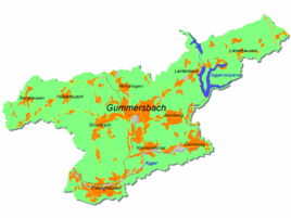
Location of Unnenberg in Gummersbach |
||
Unnenberg is a district of Gummersbach in the Oberbergischer Kreis in southern North Rhine-Westphalia , Germany .
Location and description
The village of Unnenberg on the southern slope of the Unnenberg is about eight kilometers from the city center of Gummersbach . The head of the Unnenberg belongs to the neighboring municipality of Marienheide and, at 506 m above sea level, is its highest point.
history
The place was first mentioned in a document in 1482 . The formulation reads: "For those subject to the health resort of the St. Apostelstift in Gumersbrecht, Hans pare op dem Unneberge is mentioned."
leisure
There has been an independent volunteer fire brigade in Unnenberg since 1934 (until 1934 it was part of the Lantenbach fire brigade and the surrounding area).
Hiking trails
The following hiking trails are offered by the SGV from the Unnenberg hiking car park : the A1 over 4.2 kilometers and the A2 over eight kilometers. The SGV main hiking route X11 also leads through Unnenberg, the 117-kilometer Lenne-Sieg-Weg .

