Hardt hemp garden
|
Hardt hemp garden
City of Gummersbach
Coordinates: 51 ° 1 ′ 0 ″ N , 7 ° 32 ′ 18 ″ E
|
||
|---|---|---|
| Height : | 250–296 m above sea level NN | |
| Residents : | 317 (Dec. 31, 2019) | |
| Postal code : | 51643 | |
| Area code : | 02261 | |
|
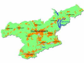
Location of Hardt-Hanfgarten in Gummersbach |
||
Hardt-Hanfgarten is a district of Gummersbach in the Oberbergischer Kreis in southern North Rhine-Westphalia , Germany .
geography
Hardt-Hanfgarten is approx. 3 km from the city center of Gummersbach . The place extends on slopes and in small side valleys on both sides of the Strombach valley .
history
Hardt-Hanfgarten was created by amalgamating the previously independent villages Vor der Hardt and Hanfgarten . The place was first mentioned in documents in 1542, when Jacob vor der Harrt among the peasantry Rospe and his servant were mentioned in the Turkish tax lists.
The name hemp garden, like the place names Bad Honnef and Hennef, indicates the hemp cultivation practiced here in ancient times .
traffic
There are two bus stops in the village, Hanfgarten and Vor der Hardt . They are served by the bus routes 317 (Gummersbach train station - Ründeroth ) and 365 (Gummersbach train station - Strombach Weststrasse) of the OVAG .
Individual evidence
- ^ Klaus Pampus: First documentary naming of Oberbergischer places (= contributions to Oberbergischen history. Sonderbd. 1). Oberbergische Department 1924 eV of the Bergisches Geschichtsverein, Gummersbach 1998, ISBN 3-88265-206-3 .


