Erlenhagen
|
Erlenhagen
City of Gummersbach
Coordinates: 51 ° 2 ′ 25 ″ N , 7 ° 36 ′ 16 ″ E
|
||
|---|---|---|
| Height : | 336-360 m above sea level NN | |
| Residents : | 192 (Dec. 31, 2019) | |
| Postal code : | 51647 | |
| Area code : | 02261 | |
|
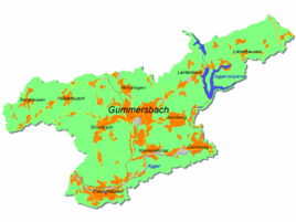
Location of Erlenhagen in Gummersbach |
||
Erlenhagen is a district of Gummersbach in the Oberbergischer Kreis in southern North Rhine-Westphalia , Germany .
geography
Erlenhagen lies on the ridge of a ridge, which, with the Lümer as the highest elevation (379 m above sea level), extends for about 4 km between the river valleys of Becke and Agger . The village can be found about 4.7 km from the center of Gummersbach, away from the main traffic arteries, on an old mountain path.
history
The first documentary mention takes place in 1542 in a Turkish tax list with a resident " op dem Erlenhage ".
Waterworks
In Erlenhagen there is a waterworks owned by the Aggerverband , where the water from the Genkeltalsperre is collected and made into drinking water .
traffic
The place has no connection to local public transport .
Individual evidence
- ^ Goossens, A: Utilization of waterworks sludge and their problems . In: gas and water compartment water - waste water . tape 137 , no. 14 , 1996, pp. 17-20 .


