Oberrengse
|
Oberrengse
City of Gummersbach
Coordinates: 51 ° 4 ′ 13 " N , 7 ° 41 ′ 8" E
|
||
|---|---|---|
| Height : | 417 (402-434) m | |
| Residents : | 64 (Jun 30, 2016) | |
| Postal code : | 51647 | |
| Area code : | 02763 | |
|
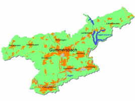
Location of Oberrengse in Gummersbach |
||
Oberrengse is a district of Gummersbach in the Oberbergischer Kreis in southern North Rhine-Westphalia , Germany .
geography
Oberrengse is approx. 13.2 km from the city center of Gummersbach. The village is located on the upper reaches of the Rengse brook , which flows west of Niederrengse to the Aggertalsperre . Neighboring districts are Drieberhausen in the west, Lieberhausen in the southwest and Hardt in the south.
history
The place was first mentioned in 1542, when a Claess and other residents of Rengese were listed in the Turkish tax list.
leisure
The Lieberhausen holiday center (“Käte-Strobel-Haus” of the NaturFreunde ), located a bit north of the village, offers especially families holiday opportunities.
Attractions
The ancient beech trees on the Rickelnberg, designated as a natural monument , are particularly worth seeing . This special form of growth of the beech is similar to the pollard willow ; the top of the tree was removed for firewood every few years.
hike
The Käte Strobel path leads from Oberrengse to the summit of the 519 m high Homert in a few minutes .
Individual evidence
- ^ Landesvermessungsamt Nordrhein-Westfalen (ed.): Nordrhein-Westfalen. Official topographic maps ("Top50") . Federal Agency for Cartography and Geodesy, 2003, ISBN 3-89439-721-7 .
- ^ Klaus Pampus: First documentary naming of Oberbergischer places (= contributions to Oberbergischen history. Sonderbd. 1). Oberbergische Department 1924 eV of the Bergisches Geschichtsverein, Gummersbach 1998, ISBN 3-88265-206-3 .

