
Aggertalsperre
| Aggertalsperre | |||||||||
|---|---|---|---|---|---|---|---|---|---|
 ( Gummersbach ) |
|||||||||
|
|||||||||
|
|||||||||
| Coordinates | 51 ° 2 '11 " N , 7 ° 38' 0" E | ||||||||
| Data on the structure | |||||||||
| Construction time: | 1927-1929 | ||||||||
| Height above valley floor: | 43.15 m | ||||||||
| Height above foundation level : | 45 m | ||||||||
| Height of the structure crown: | 286.5 m above sea level NN | ||||||||
| Building volume: | 100,000 m³ | ||||||||
| Crown length: | 225/230 m | ||||||||
| Crown width: | 11.50 m | ||||||||
| Base width: | 35 m | ||||||||
| Radius of curvature : | 250 m | ||||||||
| Data on the reservoir | |||||||||
| Altitude (at congestion destination ) | 284.4 m above sea level NN | ||||||||
| Water surface | 120 ha | ||||||||
| Storage space | 19.3 million m³ | ||||||||
| Total storage space : | 20.5 million m³ | ||||||||
| Catchment area | 40.57 km² | ||||||||
| Design flood : | 54 m³ / s | ||||||||
 |
|||||||||

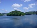
The Aggertalsperre in Oberbergisches Land is located between the cities of Gummersbach , Bergneustadt and Meinerzhagen in North Rhine-Westphalia ( Germany ).
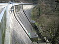
The dam in the Agger valley is fed by the Agger , Genkel and Rengse rivers and has a total storage space of 20.5 million cubic meters. The reservoir covers an area of approx. 120 to 150 ha (depending on the water level), according to other information even 193 ha. The dam wall is 225 to 230 m long and 45 m high. It was built between 1927 and 1929. Due to the three valleys, the reservoir stands out visually from many other dams.
The dam is used for power generation , flood protection, low water elevation and service water supply. According to various sources, the power plant output is 2.25 or 3 MW.
The dam is a weight dam made of cast concrete. Due to a leak on the water side , the barrier had to be released again in April 1967. A 12 cm thick bitumen layer and a 40 cm thick concrete layer were poured in front of the dam wall. These two layers were connected to the cast concrete wall made of split concrete by several thousand anchors. During this measure, the carriageway was also widened to 11.60 m on both sides of the top of the wall, as the increasing traffic could no longer be handled by the single carriageway. In 2002, major renovation and repair work was carried out. The water in the dam had to be completely drained.
On the ridge between the Agger arm and the Genkel arm ("Burg Zinne") there are remains of prehistoric ramparts (Franconian times).
history
In order to be able to cover the constantly increasing energy demand and to prevent the annually occurring flood damage, initial considerations were made as early as 1900 to 1904 about building a dam in the course of the Agger above Dümmlinghausen . Contrary to the original intention of building a weight stone wall, a decision was made for a wall made of cast concrete for rational reasons. At peak times, up to 1,600 workers were employed on the construction site.
The standard-gauge tram and goods traffic route of the Gummersbacher Kleinbahnen , which ran on Aggertalstrasse in Dümmlinghausen, was used to transport material and workers to the Genkelmuende small station; in Derschlag , the workers switched from the Aggertalbahn .
On October 10, 1928, the casting boom tore off one of the two casting towers, with four workers being killed by falling parts. Towards the end of the construction period, the construction company filed for bankruptcy , and the remaining work was carried out by companies in the area. On December 24, 1928, the trial jam began , which had to be broken off at the beginning of September 1929 due to leaks and the resulting sealing work. After the sealing work was completed, the damming began on October 18, 1929.
photos

Winter picture of the Aggertalsperre
View of the Aggertalsperre from the barrier wall
Barrier wall of the Aggertalsperre, view from the air

Barrier wall of the Aggertalsperre, view from the water


leisure
The Aggertalsperre with its possibilities for recreational activities is an attraction for visitors from the entire region. The leisure activities include numerous hiking trails, rest areas, a youth campground and a marina for sailing and rowing boats.
Diving
The dam is a quiet area for amateur divers ; The Aggertalsperre in the Gummersbach , Bergneustadt and Meinerzhagen area has become a popular place for scuba divers . The rights for underwater sports use of the dam are in the hands of Tauchsport- und Forschungsgemeinschaft Siegerland e. V. in Siegen .
Sights under water:
- fully preserved viaduct (submersible bridge arch)
- Crushing plant
- Dam wall
- Quarry stone walls
- Rock walls
See also
literature
- Peter Franke, Wolfgang Frey: Dams in the Federal Republic of Germany. Published by the National Committee for Large Dams in the Federal Republic of Germany (DNK) and the German Association for Water Management and Culture Building e. V. (DVWK). Systemdruck-GmbH, Berlin 1987, ISBN 3-926520-00-0 .
Individual evidence
- ↑ News on Tour.de: Aggertalsperre 2002 without water! Turned back the time by 15 years . Article dated June 3, 2017. Retrieved September 22, 2019
- ↑ Information board of the agger association on the barrier wall