Bruch (Gummersbach)
|
fracture
City of Gummersbach
Coordinates: 51 ° 3 ′ 11 ″ N , 7 ° 38 ′ 56 ″ E
|
||
|---|---|---|
| Height : | 293 m above sea level NN | |
| Residents : | 98 (Dec 31, 2019) | |
| Postal code : | 51647 | |
| Area code : | 02261 | |
|
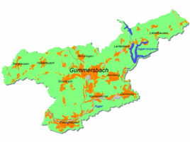
Location of Bruch in Gummersbach |
||
Bruch is a district of Gummersbach in the Oberbergischer Kreis in the administrative district of Cologne in North Rhine-Westphalia ( Germany ).
geography
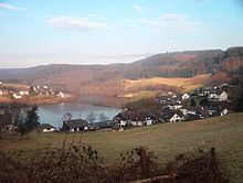
The place is 6.5 km in a north-westerly direction from the city center on the reservoir basin of the Aggertalsperre . Neighboring districts are Deitenbach and Brink .
history
Part of the village fell victim to the construction of the Aggertalsperre in 1927/1928, as did the residential and farm buildings in the neighboring village of Deitenbach.
Culture
In Bruch is the municipal lido, which was set up on the reservoir basin of the Aggertalsperre .
In addition, the start and finish point of the "Gummersbacher Talsperren-Triathlon" (organized by TV Dümmlinghausen-Hesselbach, since 1984) is located in the lido Bruch.
traffic
Bruch is only indirectly connected to public transport . The place can be reached with the bus line 318 ( Gummersbach - ( Niedernhagen -) Lieberhausen / Piene / Pernze ) via the stop Brink (from there about 400 m walk).
Individual evidence
- ^ Jürgen Woelke: Alt-Gummersbach. In contemporary images and views. Volume 2: A foray through the city and its 70 villages. Gronenberg, Gummersbach 1980, ISBN 3-88265-024-9 .


