Administrative division of Nepal until 2015
Until the formation of provinces by the Constitution of 2015 which consisted Administrative divisions of Nepal from five development regions ( Nepali : विकास क्षेत्र, Bikas kshetra ), 14 administrative regions (Nepali: अञ्चल, Anchal ) and 75 districts (Nepali: जिल्ला, Jilla ). The districts in turn consisted of more than 3000 Village Development Committees (VDC) (Nepali: गाउँ बिकास समिति, Gāu Bikās Samiti ) and 217 cities (Nepali: नगरपालिका, nagarpālikā ) (municipalities), with three differentiations among the cities, depending on their size gave. Most cities of Nepal have city status 3rd order (Nepali: नगरपालिका, nagarpālikā ), Pokhara , Lalitpur , Biratnagar , Bharatpur , Birganj , Butwal , Janakpur , Dharan and Dhangadhi have city status 2nd order (Nepali: उपमहानगरपालिका, upmahānagarpālikā ) and only Kathmandu has 1st order city law (Nepali: महानगरपालिका, mahānagarpālikā ).
The new constitution provides for the division of the country into seven provinces, which play the role of the states within the federal republic.
The information in brackets on the following list refers to the overview map on the right.
Eastern development region
The Eastern Development Region (Nepali: पुर्वाञ्चल विकास क्षेत्र Purbanchal Bikas Kshetra / Region of eastern zones ) (English: Eastern Development Region) consisted of the zones Mechi , Koshi and Sagarmatha .
Districts of the Mechi Zone :
Districts of Koshi Zone :
Districts of the Sagarmatha Zone :
- Khotang (37)
- Okhaldhunga (49)
- Saptari (63)
- Siraha (67)
- Solukhumbu (68)
- Udayapur (75)
Central development region
The Central Development Region (Nepali: मध्यमाञ्चल विकास क्षेत्र Madyamānchal Bikas Kshetra / Region of the Middle Zone ) (English: Central Development Region) consisted of the zones Janakpur , Bagmati and Narayani .
Districts of the Janakpur Zone :
Bagmati Zone Districts :
- Bhaktapur (10)
- Dhading (17)
- Kathmandu (35)
- Kabhrepalanchok (36)
- Lalitpur (38)
- Nuwakot (48)
- Rasuwa (56)
- Sindhupalchok (66)
Narayani Zone Districts :
West development region
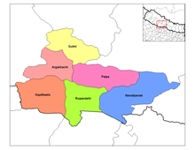
The development region West (Nepali: पश्चिमाञ्चल विकास क्षेत्र Pashchimānchal Bikās Kshetra / Development Region of the Western Zones ) (English: Western Development Region) consisted of the zones Gandaki , Lumbini and Dhaulagiri .
Gandaki Zone Districts :
Districts of the Lumbini Zone :
- Arghakhanchi (2)
- Gulmi (24)
- Kapilbastu (33)
- Nawalparasi (47)
- Palpa (50)
- Rupandehi (60)
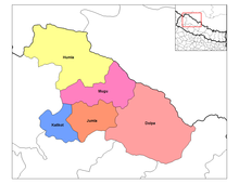
Districts of Dhaulagiri Zone :
Midwest development region
The development region Midwest (Nepali: मध्य पश्चिमाञ्चल विकास क्षेत्र Madhya Pashchimānchal Bikās Kshetra / Development Region of the Midwestern Zones ) (English: Mid-Western Development Zone) consisted of the zones Karnali , Rapti and Bheri .
Karnali Zone Districts :
Rapti Zone Districts :
- Dang Deukhuri (15)
- Pyuthan (54)
- Rolpa (58)
- Rukum (59)
- Salyan (61)
Bheri Zone Districts :
Far West development region
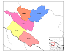
The Far-Western Development Region (Nepali: सुदुर पश्चिमाञ्चल विकास क्षेत्र Sudur Western Region Bikas Kshetra / Region of Far Western Zones ) (English: Far-Western Development Zone) consisted of the zones Seti and Mahakali .
Seti Zone Districts :
Mahakali Zone Districts :
- Baitadi (4)
- Dadeldhura (13)
- Darchula (16)
- Kanchanpur (32)
Web links
- Districts, Village Development Committees and their data from the 2001 census at Digital Nepal of the University of Cambridge
Individual evidence
- ↑ Central Bureau of Statistics, Census 2011 Final Results ( Final results ) (p 6 + 7). ( Memento of July 31, 2013 in the Internet Archive ) (PDF; 2.1 MB)
- ↑ Central Bureau of Statistics, Census 2011 Final Results ( Final results ) (starting on page 8). ( Memento of July 31, 2013 in the Internet Archive ) (PDF; 2.1 MB)
- ↑ http://www.citypopulation.de/php/nepal-admin.php
- ↑ http://www.myrepublica.com/portal/index.php?action=news_details&news_id=74336


