Tanahu
| तनहू जिल्ला Tanahu District
|
|
|---|---|
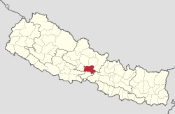
 Location of the Tanahu district (red) in Nepal |
|
| Basic data | |
| Country | Nepal |
| province | Gandaki |
| Seat | Vyas |
| surface | 1546 km² |
| Residents | 323,288 (2011 census) |
| density | 209 inhabitants per km² |
| ISO 3166-2 | NP-P4 |
| VDC and cities (blue) in Tanahu | |
Coordinates: 27 ° 55 ' N , 84 ° 12' E
The Tanahu district ( Nepali तनहू जिल्ला ) is one of the 77 districts in Nepal .
Its main town, Byas, is in the Gandaki administrative zone .
geography
The 1546 km² district is located in the center of Nepal in the foothills of the Himalayas . Its district neighbors are Kaski , Lamjung and Gorkha in the north, Chitwan in the east, Nawalparasi and Palpa in the south and Syangja in the west . The district is bounded in the south by the lower course of the Kali Gandaki and in the east by the Marsyangdi . The Seti Gandaki and its left tributary Madi Khola flows through the district .
population
According to the census, the district had 315,237 in 2001 with a population density of 203.9 people / km². The largest ethnic group in this district are the Gurung . Many residents of Madi Khola make a living from fishing.
Administrative division
Cities ( municipalities ) in Tanahu District:
Village Development Committees (VDCs) in Tanahu District:
- Arunodaya
- Baidi
- Basantapur
- Bhanumati
- Bhimad
- Bhirkot
- Chhang
- Chhimkeswari
- Chhipchhipe
- Chok Chisapani
- Deurali
- Devghat
- Gajarkot
- Ghansikuwa
- Jamune Bhanjyang
- Kabilas
- Kahu Shivapur
- Keshavtar
- Kihun
- Kota
- Feces barable
- Kyamin
- Majhakot
- Manpang
- Phirphire
- Pokhari Bhanjyang
- Purkot
- Raipur
- Ramjakot
- Ranipokhari
- Risti
- Rupakot
- Samungbhagwati
- Satiswara
- Sundhara
- Syamgha
- Tanahunsur
- Thaprek
- Virlung
Web links
- Map of Tanahu District - PDF document (2.13 MB) from Digital Himalaya. Last accessed on April 28, 2011.
Individual evidence
- Census Nepal (2001) - at statoids.com (English). Last accessed on April 27, 2011.
- ↑ Central Bureau of Statistics, Census 2011: National Report (pp. 51–52, Population Total and Area in Sq. Km ). ( Memento of the original from April 18, 2013 in the Internet Archive ) Info: The archive link was inserted automatically and has not yet been checked. Please check the original and archive link according to the instructions and then remove this notice. (PDF; 7.5 MB)
