Sankhuwasabha
| सङ्खुवासभा जिल्ला Sankhuwasabha District
|
|
|---|---|
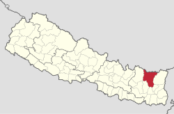
 Location of the Sankhuwasabha district (red) in Nepal |
|
| Basic data | |
| Country | Nepal |
| Capital | Khandbari |
| surface | 3480 km² |
| Residents | 158,742 (2011 census) |
| density | 46 inhabitants per km² |
| ISO 3166-2 | NP-P1 |
| Website | ddcsankhuwasabha.gov.np |
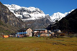
| Yangle Kharka, a village in Sankhuwasabha | |
Coordinates: 27 ° 38 ' N , 87 ° 13' E
The Sankhuwasabha District ( Nepali सङ्खुवासभा जिल्ला ) is one of 77 districts in Nepal and has been part of the Constitution of 2015 for Province No. 1, .
At the 2001 census it had 159,203 inhabitants; in 2011 there were 158,742.
The district is characterized by the deep valley of the Arun , one of the three great rivers of Nepal, which is ascribed a high hydropower potential.
Indigenous peoples living in the district include the Yakkhas , Lohorung , Kulung , Rai , Gurung and Limbu .
Administrative division
Cities in Sankhuwasabha District:
Gaunpalikas (rural communities):
Web links
Commons : Sankhuwasabha District - Collection of images, videos and audio files
Individual evidence
- ↑ Schedule-4 States, and Districts to be included in the concerned States. - Nepal Law Commission. Retrieved December 13, 2018 .
- ↑ Central Bureau of Statistics, Census 2011: National Report (pp. 51–52, Population Total and Area in Sq. Km ). ( Memento of the original from April 18, 2013 in the Internet Archive ) Info: The archive link was inserted automatically and has not yet been checked. Please check the original and archive link according to the instructions and then remove this notice. (PDF; 7.8 MB)
