Achham
| अछाम जिल्ला Achham District
|
|
|---|---|
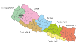
 Location of the Achham district (dark green) in the Sudurpashchim province and in Nepal |
|
| Basic data | |
| Country | Nepal |
| province | Sudurpashchim |
| Seat | Mangalsen |
| surface | 1692 km² |
| Residents | 257,477 (2011 census) |
| density | 152 inhabitants per km² |
| ISO 3166-2 | NP-P7 |
| Website | daoachham.moha.gov.np |
| Lake at Ramarosan | |
Coordinates: 29 ° 7 ' N , 81 ° 18' E
The Achham District ( Nepali अछाम जिल्ला Achhām Jillā ) is one of 77 districts in Nepal and has belonged to the Sudurpashchim Province since the 2015 constitution .
history
Achham was part of the Seti administrative zone until 2015 .
geography
The administrative seat is Mangalsen . Achham is one of the most remote districts in the country. Compared to other districts in the region, Achham is relatively well connected to the road network of Nepal, as more than half of the former Village Development Committees are connected to it.
The district extends over the Front Himalayas . It is bounded in the west by the Lower Seti and in the southeast and south by the Karnali . The Budhiganga flows through the northwestern part of Achham. The Khaptad National Park extends in the far northwest of the district .
In 2017, Achham was one of the ten poorest and most underdeveloped districts in Nepal with a Human Development Index value of less than 0.4.
Agriculture (including livestock and poultry), home production and trade are the main sources of income for the district. Agriculture is the main source of income for around 89% of households. Around 52% of the area is covered with forest, so that in addition to forestry there is also great potential for the collection and processing of herbs.
Residents
At the 2011 census, Achham had 257,477 inhabitants.
The overall literacy rate in the district in 2018 was 53%, but that of women was only 37%. Women suffer from gender-specific discrimination in education, nutrition, and social and cultural norms. Discrimination against women also occurs in the form of the Chhaupadi practice of banishing women to a hut during their menstruation.
Caste discrimination is still widespread in the district. A number of disadvantaged groups live in the district such as the former haliyas ( slaves living in debt ).
Administrative division
Cities ( municipalities ) in the Achham district:
Gaunpalikas (rural communities):
By 2017, the district was divided into the following Village Development Committees (VDCs):
- Babala
- Bangabata
- Bannatoli
- Baradadivi
- Basti
- Batulasen
- Bhairabsthan
- Bhatakatiya
- Binayak
- Bindhyabasini
- Birpath
- Budhakot
- Chapamandau
- Chhatara
- Darna
- Devisthan
- Dhakari
- Dhamali
- Dharaki
- Dhodasain
- Dhudharukot
- Dhungachalna
- Dumi
- Gajara
- Ghodasen
- Hatikot
- Hichma
- Janalikot
- Kalagaun
- Kalekanda
- Kalika
- Kalikasthan
- Khaptad
- Khodasadevi
- Kuika
- Kushkot
- Layati
- Lungra
- Malatikot
- Marku
- Nada
- Nandegata
- Patal feces
- Payal
- Pulletala
- Rahaph
- Ramarosan
- Raniban
- Risidaha
- Sakot
- Santada
- Siudi
- Sutar
- Tadigaira
- Thanti
- Timilsain
- Toli
- Tosi
- Tumarkhad
- Walant
- Warla
Web links
Individual evidence
- ↑ Schedule-4 States, and Districts to be included in the concerned States. - Nepal Law Commission. Retrieved December 13, 2018 .
- ↑ Achham "Sakchyam programs. In: Sakchyam Access to Finance for the Poor Program. Retrieved January 25, 2019 .
- ↑ Bajura, not Saptari, is the most backward district of Nepal. December 14, 2017, accessed January 17, 2019 .
- ↑ a b c Achham «Sakchyam programs. In: Sakchyam Access to Finance for the Poor Program. Retrieved January 25, 2019 .
- ↑ Central Bureau of Statistics, Census 2011: National Report (pp. 51–52, Population Total and Area in Sq. Km ). ( Memento from May 25, 2013 in the Internet Archive ) (PDF; 7.8 MB)
- ↑ a b Nepal: Administrative Unit - State 7 Map | UN Nepal Information Platform. Retrieved January 15, 2019 .
