
Lamjung
| लमजुङ जिल्ला Lamjung District
|
|
|---|---|
 Location of the Lamjung district (dark blue) in the Gandaki province and in Nepal |
|
| Basic data | |
| Country | Nepal |
| province | Gandaki |
| surface | 1692 km² |
| Residents | 167,724 (2011 census) |
| density | 99 inhabitants per km² |
| ISO 3166-2 | NP-P4 |
| Website | ddclamjung.gov.np ( engl. / nepali ) |
Coordinates: 28 ° 14 ' N , 84 ° 23' E
The Lamjung ( Nepali लमजुङ जिल्ला ) district is one of 77 districts in Nepal and has belonged to the Gandaki Province since the 2015 constitution .
Its main town is Besisahar .
history
Until 2015, Lamjung belonged to the Gandaki Administrative Zone .
geography
The 1692 km² district is located in the central Himalayas in the center of Nepal. Its district neighbors are Kaski , Manang , Gorkha and Tanahu . The topography is determined by the Marsyangdi River , which rises in the neighboring Manang district and flows through Lamjung in a north-south direction.
population
According to the 2001 census, the district had 177,149 inhabitants in 2001. The literacy rate was 56% and the population density was 104.7 people / km². The largest ethnic group in this district are the Gurung .
Administrative division
Cities in Lamjung District:
Gaunpalikas (rural communities):
- Dordi Rural
- Dudhpokhari
- Kwhlosothar
- Marsyandi
By 2017, the district was divided into the following Village Development Committees (VDCs):
- Archalbot
- Bahundanda
- Bajhakhet
- Balungpani
- Bansar
- Bharte
- Bhoje
- Bhujung
- Bhulbhule
- Bichaur
- Chandreshwar
- Chiti
- Dhodeni
- Dhuseni
- Dudhpokhari
- Duradanda
- Gaunda
- Ghanpokhara
- Ghermu
- Gilung
- Hiletaksar
- Ilampokhari
- Khudi
- Kolki
- Maling
- Nalma
- Nauthar
- Neta
- Pachok
- Pasagaun
- Phaleni
- Puran excrement
- Sri Manjyang
- Simpani
- Sindure
- Taghring
- Uttarkanya
Infrastructure
In the 61 Village Development Commites (VDCs) , the residents have been practicing traditional agriculture and animal husbandry since ancient times . The district is also rich in natural resources , which, however, have to remain unused due to a lack of road infrastructure . Most of the villages, however, are connected to a well-maintained network of supply paths. The Annapurna Circuit trekking route also runs through the Lamjung district on these paths and many residents now live from tourism (supply and accommodation for the trekking groups) on this route .
electricity
Most of the villages in the district are connected to the electricity grid.
On December 14, 2008, the Mid-Marsyangdi Hydropower Project (MMHEP), the second largest hydropower project in Nepal with 70 megawatts , began. The project started in June 2001 with joint investments by the government of Nepal, Germany and the Nepal Electricity Authority . The dam is located about 5 km southeast of Besisahar.
Health and education
In Lamjung there were five universities (including branches), 15 high schools and 40 private and 348 public schools. There is one hospital throughout the district , but each village has at least one infirmary .
Lamjung was declared the 17th district with full literacy on July 16, 2015. In 2019, according to a study by the district, around eight percent of residents over six years of age were still illiterate. The literacy rate for residents between six and sixty years of age is over 96%.
communication
Post offices own each of the 61 VDCs. Almost every village is connected to the fixed telephone network. There are also GSM or CDMA cell phone connections from Nepal Telecom and Spice Nepal . The district has recently been connected to the fast ADSL internet connection. The print media include: B. Lamjung Highlights and Antarang available. Lamjung currently owns a community FM transmitter (95 MHz Marsyangdi).
photos

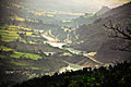
View from the Lamjung district to Annapurna II

Village in Lamjung District

The Marsyangdi River
The hydropower project
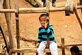
Gurung boy plays on a traditional wooden swing


Web links
- Lamjung district map - PDF document (2.48 MB) from Digital Himalaya. Last accessed on April 28, 2011.
Individual evidence
- ↑ Central Bureau of Statistics, Census 2011: National Report (pp. 51–52, Population Total and Area in Sq. Km ). ( Memento of the original from April 18, 2013 in the Internet Archive ) Info: The archive link was inserted automatically and has not yet been checked. Please check the original and archive link according to the instructions and then remove this notice. (PDF; 7.8 MB)
- ↑ Schedule-4 States, and Districts to be included in the concerned States. - Nepal Law Commission. Retrieved December 13, 2018 .
- ↑ Nepal Census (2001) - at statoids.com (English). Last accessed on April 27, 2011.
- ↑ a b Nepal: Administrative Unit - State 4 Map | UN Nepal Information Platform. Retrieved January 1, 2019 .
- ↑ About Lamjung - at elamjung.com (English). Last accessed on April 28, 2011.
- ↑ Middle-Marsyangdi Hydro-Electric Project (MMHEP) ( page no longer available , search in web archives ) Info: The link was automatically marked as defective. Please check the link according to the instructions and then remove this notice. (PDF; 50 kB) - Nepal Case Study (English) Last accessed on April 28, 2011.
- ↑ Eight per cent locals illiterate in Lamjung. The Himalayan Times, February 26, 2019, accessed February 26, 2019 .
- ↑ Eight per cent locals illiterate in Lamjung. The Himalayan Times, February 26, 2019, accessed February 26, 2019 .
Achham | Arghakhanchi | Baglung | Baitadi | Bajhang | Bajura | Bank | Bara | Bardiya | Bhaktapur | Bhojpur | Chitwan | Dadeldhura | Dailekh | Dang Deukhuri | Darchula | Dhading | Dhankuta | Dhanusha | Dolakha | Dolpa | Doti | Gorkha | Gulmi | Humla | Ilam | Jajarkot | Jhapa | Jumla | Kabhrepalanchok | Kailali | Calicot | Kanchanpur | Kapilbastu | Kaski | Kathmandu | Khotang | Lalitpur | Lamjung | Mahottari | Makwanpur | Manang | Morang | Mugu | Mustang | Myagdi | Nawalparasi (Bardaghat Susta East) | Nawalparasi (Bardaghat Susta West) | Nuwakot | Okhaldhunga | Palpa | Panchthar | Parbat | Parsa | Pyuthan | Ramechhap | Rasuwa | Rautahat | Rolpa | Rukum East | Rukum West | Rupandehi | Salyan | Sankhuwasabha | Saptari | Sarlahi | Sindhuli | Sindhupalchok | Siraha | Solukhumbu | Sunsari | Surkhet | Syangja | Tanahu | Taplejung | Terhathum | Udayapur