Bank
| बाँके जिल्ला Banke District
|
|
|---|---|
 Location of the Banke district (red) in Nepal |
|
| Basic data | |
| Country | Nepal |
| province | Province No. 5 |
| Seat | Nepalganj |
| surface | 2337 km² |
| Residents | 491,313 (2011 census) |
| density | 210 inhabitants per km² |
| ISO 3166-2 | NP-P5 |
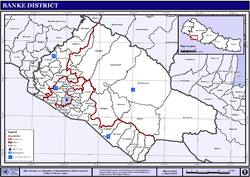
| VDCs and cities (blue) in Banke | |
Coordinates: 28 ° 6 ' N , 81 ° 42' E
The District Banke ( Nepali बाँके जिल्ला Bānke Jillā ) is one of 77 districts in Nepal .
It is located in the Bheri administrative zone in Inner Terai .
Residents
The district had 385,840 inhabitants in 2001; In 2011 there were 491,313. The administrative seat is Nepalganj .
Administrative division
Cities in Banke District:
Nepalganj has the city rights of the 2nd order .
Village Development Committees (VDCs) in Banke District:
- Bageswari
- Banakatawa
- Banakatti
- Basudevapur
- Bejapur
- Belahari
- Belbhar
- Betahani
- Bhawaniyapur
- Binauna
- Chisapani
- Ganapur
- Gangapur
- Hirminiya
- Holiya
- Indrapur
- Jaispur
- Kalaphanta
- Kamdi
- Kanchanapur
- Kathkuiya
- Khajura Khurda
- Khaskarkado
- Khaskusma
- Laxmanpur
- Mahadevpuri
- Manicapure
- Matahiya
- Narainapur
- Naubasta
- Parsapur
- Phatepur
- Piparhawa
- Puraina
- Puraini
- Radhapur
- Raniyapur
- Saigaun
- Samserganj
- Sitapur
- Sonapur
- Titahiriya
- Udarapur
- Udayapur
Web links
Commons : District Banke - Collection of images, videos, and audio files
Individual evidence
- ↑ Central Bureau of Statistics, Census 2011: National Report (pp. 51–52, Population Total and Area in Sq. Km ). ( Memento from May 25, 2013 in the Internet Archive ) (PDF; 7.8 MB)
