
Nuwakot
| नुवाकोट जिल्ला Nuwakot District
|
|
|---|---|
 Location of the Nuwakot district (red) in Nepal |
|
| Basic data | |
| Country | Nepal |
| province | Bagmati |
| Seat | Bidur |
| surface | 1121 km² |
| Residents | 277,471 (2001 census) |
| density | 248 inhabitants per km² |
| ISO 3166-2 | NP-P3 |
 |
|
Coordinates: 27 ° 53 ' N , 85 ° 8' E
The Nuwakot District ( Nepali नुवाकोट जिल्ला , Nuvākoṭ jillā ) is one of 75 districts in Nepal .
This is located on the Trishuli River in the Bagmati administrative zone . At the 2001 census, this administrative unit had 288,478 inhabitants, in 2011 it was 277,471.
The district is named after the mountain village and the fortress of the same name Nuwakot , built in the 18th century in the Malla style on the trade route between Tibet and the Kathmandu valley , strategically above the city of Bidur .
Nuwakot belonged to a total of 9 Ghorka fortresses of Pritvi Narayan Shah and was the capital of his empire until his capture of Kathmandu in 1768.
Administrative division
Cities in Nuwakot District:
Village Development Committees (VDCs) in Nuwakot District:
- Bageswori Chokade
- Balkumari
- Barsunchet
- Belkot
- Beteni
- Bhadrutar
- Bhalche
- Budhasing
- Bungtang
- Charghare
- Chaturale
- Chaughada
- Chauthe
- Chhap
- Dangsing
- Deurali
- Duipipal
- Ganeshthan
- Gaunkharka
- Gerkhu
- Ghyangphedi
- Gorsyang
- Jiling
- Kakani
- Calibas
- Kalika dump
- Kalyanpur
- Kaule
- Khadgabhanjyang
- Kharanitar
- Kholegaun Khanigaun
- Kintang
- Kumari
- Lachyang
- Likhu
- Madanpur
- Mahakali
- Manakamana
- Narjamandap
- Okharpauwa
- Panchakanya
- Phikuri
- Ralukadevi
- Councilmate
- Rautbesi
- Salme
- Samari
- Samundradevi
- Samundratar
- Shikharbesi
- Sikre
- Sundaradevi
- Sunkhani
- Suryamati
- Talekhu
- Taruka
- Thanapati
- Thansing
- Thaprek
- Dab
- Urleni
photos
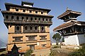
palace

Agricultural terraces near Duipipal

Belkot

District of Duipipal

Kakani

Councilmate

Dhimay drums accompany the stick dance Taktuke


Web links
Individual evidence
- ↑ General Bureau of Statistics, Kathmandu, Nepal, Nov. 2012
Achham | Arghakhanchi | Baglung | Baitadi | Bajhang | Bajura | Bank | Bara | Bardiya | Bhaktapur | Bhojpur | Chitwan | Dadeldhura | Dailekh | Dang Deukhuri | Darchula | Dhading | Dhankuta | Dhanusha | Dolakha | Dolpa | Doti | Gorkha | Gulmi | Humla | Ilam | Jajarkot | Jhapa | Jumla | Kabhrepalanchok | Kailali | Calicot | Kanchanpur | Kapilbastu | Kaski | Kathmandu | Khotang | Lalitpur | Lamjung | Mahottari | Makwanpur | Manang | Morang | Mugu | Mustang | Myagdi | Nawalparasi (Bardaghat Susta East) | Nawalparasi (Bardaghat Susta West) | Nuwakot | Okhaldhunga | Palpa | Panchthar | Parbat | Parsa | Pyuthan | Ramechhap | Rasuwa | Rautahat | Rolpa | Rukum East | Rukum West | Rupandehi | Salyan | Sankhuwasabha | Saptari | Sarlahi | Sindhuli | Sindhupalchok | Siraha | Solukhumbu | Sunsari | Surkhet | Syangja | Tanahu | Taplejung | Terhathum | Udayapur