Dang Deukhuri
| दाङ देउखुरी जिल्ला Dang Deukhuri District
|
|
|---|---|
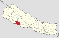
 Location of the Dang Deukhuri district (red) in Nepal |
|
| Basic data | |
| Country | Nepal |
| province | Province No. 5 |
| Seat | Ghorahi |
| surface | 2955 km² |
| Residents | 552,583 (2011 census) |
| density | 187 inhabitants per km² |
| ISO 3166-2 | NP-P5 |
| VDCs and cities (blue) in Dang Deukhuri | |
Coordinates: 27 ° 58 ' N , 82 ° 25' E
The district of Dang Deukhuri ( Nepali दाङ देउखुरी जिल्ला dāṅ deukhurī jillā ), often just called Dang , is a district in the Inner Terai in the Rapti administrative zone in Nepal , about 280 km west of Kathmandu , and borders India .
geography
The district is characterized by two large, parallel running valleys of the Mahabharat in east-west direction , the Dang and the Deukhuri . They are separated by the approximately 800 m high (above sea level) band-like mountain range of the Dudhwas. The wider Dang valley to the north is about 600 m above sea level, while the Deukhuri valley is around 250 m . The latter is, in turn, by the gang-extending, approximately 600 m high mountain range of Siwaliks from the exterior Terai and the swing plane separated.
population
In the past, the dry and unproductive land of the Dudhwaberge created a buffer between the cultures of the Ganges plain and the Inner Terai. The Deukhuri Valley, like the entire Terai, was infested with malaria until the late 1950s and is only sparsely populated to this day, mainly by the Tharu , who had developed a certain resistance to malaria. The drier and higher lying Dang Valley was less affected by malaria and was therefore more attractive to settlers from the south, especially after malaria was largely displaced in the 1960s. The district's two cities, Ghorahi and Tulsipur , are located in the Dang Valley.
Administrative division
Cities ( municipalities ) in Dang Deukhuri District:
Village Development Committees (VDCs) in Dang Deukhuri:
- Baghmare
- Bela
- Bijauri
- Dhanauri
- Dharna
- Duruwa
- Gadhawa
- Gangapara trace
- Gobardiya
- Goltakuri
- Halwar
- Hansipur
- Hekuli
- Kabhre
- Koilabas
- Kothari
- Lalmatiya
- Laxmipur
- Loharpani
- Mahadewa
- Manpur
- Pachahiya
- Panchakule
- Pawan Nagar
- Phulbari
- Purandhara
- Rajpur
- Rampur
- Saigha
- Satbariya
- Saudiyar
- Shantine agar
- Sisahaniya
- Srigaun
- Syuja
- Tarigaun
- Urahari
Web links
Individual evidence
- ↑ Central Bureau of Statistics, Census 2011: National Report (pp. 51–52, Population Total and Area in Sq. Km ). ( Memento from May 25, 2013 in the Internet Archive ) (PDF; 7.8 MB)
