Morang
| मोरङ जिल्ला Morang District
|
|
|---|---|
 Location of the Morang district (red) in Nepal |
|
| Basic data | |
| Country | Nepal |
| Capital | Biratnagar |
| surface | 1855 km² |
| Residents | 965,370 (2011 census) |
| density | 520 inhabitants per km² |
| ISO 3166-2 | NP-P1 |
| Website | www.ddcmorang.gov.np |
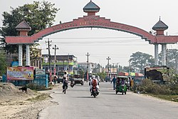
| Biratnagar city limits, Morang | |
Coordinates: 26 ° 39 ' N , 87 ° 29' E
The Morang District ( Nepali मोरङ जिल्ला ) is one of 77 districts in Nepal and has been part of the Constitution of 2015 for Province No. 1, .
Its capital is Biratnagar , which is also the provisional capital of the province.
history
The district is named after the Limbu king Mawrong Mung Hang, who founded the kingdom of Morang in the early 7th century. It comprised the terai areas between the Koshi and Mechi rivers . The capital and fortress were in Rongli, today's Rangeli . In 849, King Uba Morang incorporated Limbuwan into his kingdom . From 1584 Morang was ruled by the Limbu king Sangla Ing from Varatappa (east of today's Bijayapur near Dharan ). The Ing dynasty was followed by the Sen and Khebang dynasties until 1774, when the Gorkha king Prithvi Narayan Shah , the founder of Nepal, annexed Limbuwan. The last king of Morang was Buddhi Karna Raya Khebang .
Geography, economy
The 1855 km² district is located in southeastern Nepal in the Terai on the Indian border. District neighbors are Sunsari , Jhapa and Dhankuta . The administrative seat of Biratnagar is the fourth largest city in Nepal; other important places are Urlabari , Biratchowk and Rangeli.
Until the middle of the last century there were still extensive primeval forests; Small remnants of it can still be found at the foot of the Himalayas ( sal forests ). Today the district is predominantly agricultural with the cultivation of rice and jute. Nevertheless, Morang has the highest industrial density in the country.
population
According to the 2011 census, the district had 965,370 inhabitants and the population density was 520 people / km². Various ethnic groups live in Morang such as the Rajbanshi, Satar, Meche, Koche, Limbu, Dhimal and Gangain. Other ethnic groups such as Rai, Dhangad, Tamang, Uraon, Magar, Gurung and many others came to the district in the late 19th century. Besides Nepali, Limbu and Maithili are the most common languages.
Infrastructure
Morang is one of the most developed areas in Nepal. The district is relatively well served by roads. There is an airport in Biratnagar.
Administrative division
The following cities are located in the district:
Gaunpalikas (rural communities):
Web links
Individual evidence
- ↑ Central Bureau of Statistics, Census 2011: National Report (pp. 51–52, Population Total and Area in Sq. Km ). ( Memento of the original from April 18, 2013 in the Internet Archive ) Info: The archive link was inserted automatically and has not yet been checked. Please check the original and archive link according to the instructions and then remove this notice. (PDF; 7.8 MB)
- ↑ Schedule-4 States, and Districts to be included in the concerned States. - Nepal Law Commission. Retrieved December 13, 2018 .
- ^ Nepal government announces Provincial Capitals and Chiefs | DD News. Retrieved December 15, 2018 .
