Mahottari
| महोत्तरी जिल्ला Mahottari District
|
|
|---|---|
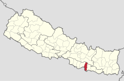
 Location of the Mahottari district (red) in Nepal |
|
| Basic data | |
| Country | Nepal |
| province | Province No. 2 |
| Seat | Jaleshwar |
| surface | 1002 km² |
| Residents | 627,580 (2011 census) |
| density | 626 inhabitants per km² |
| ISO 3166-2 | NP-P2 |
| VDCs and cities (blue) in Mahottari | |
Coordinates: 26 ° 53 ' N , 85 ° 49' E
The Mahottari district ( Nepali महोत्तरी जिल्ला ) is one of 77 districts in Nepal .
The district is located in the Terai in the Janakpur administrative zone .
In 2001 it had 553,481 inhabitants, in 2011 it was 627,580.
Administrative division
Cities in Mahottari District:
Village Development Committees (VDCs) in Mahottari District:
- Aurahi
- Bagada
- Bagiya Banchauri
- Bairgiya Laksminiya
- Balawa
- Banauli Donauli
- Banauta
- Basabitti
- Bathnaha
- Belgachhi
- Bharatpur
- Bhatauliya
- Bijayalpura
- Bramarpura
- Damhi Marai
- Dhamaura
- Dharmapur
- Dhirapur
- Ekadarabela
- Ekarahiya
- Etaharwakatti
- Gaidha Bhetpur
- Gonarpura
- Halkhori
- Hariharpur Harinagari
- Hathilet
- Hatisarwa
- Khairbanni
- Khaya Mara
- Khopi
- Khuttapipradhi
- Kolhusa Bagaiya
- Laksminiya
- Loharpatti
- Mahadaiyatapanpur
- Mahottari
- Majhora Bishnupur
- Manara
- Matihani
- Meghanath Gorhanna
- Nainhi
- Padaul
- Parsa Pateli
- Parsadewadh
- Pashupatin agar
- Pigauna
- Pipra
- Phulahatta Parikauli
- Phulakaha
- Pokharibhinda Samgrampur
- Raghunathpur
- Ramgopalpur
- Ratauli
- Sahasaula
- Sahorawa
- Sandha
- Sarpallo
- Shamsi
- Simardahi
- Singyahi
- Sisawakataiya
- Sonama
- Sonamar
- So
- Sripur
- Suga Bhawani
- Sundarpur
- Vangaha
Web links
Commons : Mahottari District - Collection of images, videos and audio files
Individual evidence
- ↑ Household and population by districts, Central Bureau of Statistics (CBS) Nepal ( Memento from July 31, 2013 in the Internet Archive ) (PDF; 2.1 MB)
