Janakpur (zone)
| गण्डकी अञ्चल Janakpur
|
|
|---|---|
 Location of the Janakpur Zone in Nepal |
|
| Basic data | |
| Country | Nepal |
| region | Central development region |
| Seat | Janakpur |
| surface | 9669 km² |
| Residents | 5,871,100 (2016) |
| density | 607 inhabitants per km² |
|
ISO 3166-2 (obsolete) |
NP-YES |
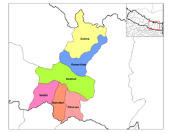
| Districts in the Janakpur Zone | |
Coordinates: 27 ° 16 ' N , 85 ° 56' E
Janakpur ( Nepali जनकपुर अञ्चल Janakpur Anchal ) was one of the 14 former administrative zones in Nepal , named after the largest city. The administrative seat was Janakpur .
The zone was in what was then the central development region and stretched from the Indian border to the Tibetan highlands behind the Chinese border.
Janakpur consisted of 6 districts:
Through the constitution of September 20, 2015 and the resulting reorganization of Nepal into provinces, the districts of this zone were divided up and assigned to the newly created provinces No. 2 and Bagmati .
Web links
Commons : Janakpur Administrative Zone - Collection of pictures, videos and audio files
Individual evidence
- ^ Nepal: Administrative Division (Provinces and Districts) - Population Statistics, Charts and Map. Retrieved November 16, 2018 .
- ^ Constitution of Nepal, Schedule-4 . 2015 ( deutsch-nepal.de [PDF] Unofficial English Translation).
