Dolpa
| डोल्पा जिल्ला Dolpa District
|
|
|---|---|
 Location of the Dolpa District (darker purple) in the Karnali Province and in Nepal |
|
| Basic data | |
| Country | Nepal |
| province | Karnali |
| Seat | Dunai |
| surface | 7889 km² |
| Residents | 36,700 (2011 census) |
| density | 4.7 inhabitants per km² |
| ISO 3166-2 | NP-P6 |
| Website | ddcdolpa.gov.np |
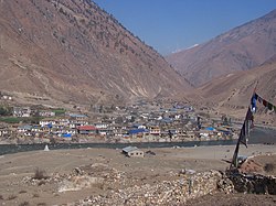
| District capital Dunai | |
Coordinates: 29 ° 10 ' N , 83 ° 5' E
The Dolpa District ( Nepali डोल्पा जिल्ला Dolpa Jillā ) is one of 77 districts in Nepal and has belonged to the Karnali Province since the constitution of 2015 and is the largest district in Nepal by area.
The administrative seat is in Ward Dunai of the city of Thuli Beri .
geography
The district is considered to be one of the most remote areas in Nepal. Dolpa is surrounded in the east by the former Kingdom of Lo (now Mustang) , in the south by the districts of Myagdi , Rukum and Jajarkot and in the west by the two districts of Jumla and Mugu . In the north, the region borders on the Tibet Autonomous Region of the People's Republic of China .
Until November 2018, it had no road connection to other districts. On November 18, a 103 km long road was opened from Pasagadh in the Jajarkot district, which connects the capital Dunai with the national road network.
Almost half of the district is covered with 3555 km² by the She-Phoksundo National Park. This is located in the northern part of the district, the Dolpo region.
history
The district was originally in the Karnali administrative zone .
Residents
In 2011, 36,700 people lived in Dolpa.
The population is predominantly Hindu or Buddhist ; around 5% are followers of the old Bon religion.
Administrative division
Cities in Dolpa District:
Gaunpalikas (rural communities):
Until 2017, the Dolpa District consisted of the following Village Development Committees (VDCs):
Web links
- Dolpa trekking maps ( Memento from June 20, 2012 in the Internet Archive )
Individual evidence
- ^ Federal VDC Relation. In: UN Nepal Information Platform: Common Data Repository. Accessed January 1, 2019 .
- ^ Dolpa headquarters linked to national road network. Accessed January 1, 2019 .
- ↑ Central Bureau of Statistics, Census 2011: National Report (pp. 51–52, Population Total and Area in Sq. Km ). ( Memento from May 25, 2013 in the Internet Archive ) (PDF file; 7.5 MB)
