Seti Gandaki
|
Seti Gandaki Seti |
||
|
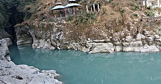
Seti Gandaki at Ramghat, Pokhara |
||
| Data | ||
| location | Gandaki , Narayani ( Nepal ) | |
| River system | Ganges | |
| Drain over | Trishuli → Gandak → Ganges → Indian Ocean | |
| Headwaters |
Annapurna Himal 28 ° 29 ′ 56 ″ N , 84 ° 1 ′ 7 ″ E |
|
| muzzle |
Trishuli coordinates: 27 ° 49 ′ 16 " N , 84 ° 27 ′ 17" E 27 ° 49 ′ 16 " N , 84 ° 27 ′ 17" E |
|
| Mouth height | approx. 200 m
|
|
| length | approx. 150 km | |
| Catchment area | 2943 km² | |
| Drain |
MQ |
300 m³ / s |
| Left tributaries | Madi Khola | |
| Right tributaries | Mardi Khola , Phusre Khola | |
| Big cities | Pokhara | |
| Medium-sized cities | Lekhnath , Vyas | |
The Seti Gandaki (नेपाली: सेती गण्डकी नदी) ("White Gandaki", short form: Seti , not to be confused with the Seti , tributary of the Karnali ) is a right tributary of the Trishuli in central Nepal .
It rises in the Annapurna Himal between the 7000 meter peaks Annapurna II and Annapurna III . It initially flows about 40 km through a deep gorge in a southerly direction and reaches a plateau. The river turns to the southeast and flows through the city of Pokhara . At Lekhnath the Seti Gandaki turns south. Later it cuts through the Himalayan foothills in an easterly direction. At Vyas the Madi Khola flows into the river from the left. Finally, at Kabilas, it meets the Trishuli, the source of the Gandak ( Narayani ). In the south and west, the 2943 km² catchment area of the Seti Gandaki borders that of the Kali Gandaki , which joins the Trishuli 15 km further south. The Seti Gandaki has a length of about 150 km.
The lower 70 km of the Seti Gandaki are used as a rafting route.
Web links
Individual evidence
- ↑ a b geog.ucsb.edu
