Gandak
| Gandak - Narayani | ||
|
Gandak (Naranyani) near Triveni on the Nepal-India border |
||
| Data | ||
| location |
Nepal , Uttar Pradesh , Bihar ( India ) |
|
| River system | Ganges | |
| Drain over | Ganges → Indian Ocean | |
| Confluence of |
Kali Gandaki and Trishuli 27 ° 44 ′ 27 ″ N , 84 ° 25 ′ 20 ″ E |
|
| Source height | 190 m | |
| muzzle |
Ganges coordinates: 25 ° 39 ′ 22 " N , 85 ° 10 ′ 41" E 25 ° 39 ′ 22 " N , 85 ° 10 ′ 41" E |
|
| Mouth height | 44 m | |
| Height difference | 146 m | |
| Bottom slope | approx. 0.37 ‰ | |
| length | approx. 400 km (including source river Kali Gandaki 650 km) | |
| Catchment area | 46,300 km² | |
| Drain |
MQ |
1760 m³ / s |
| Left tributaries | Rapti | |
| Big cities | Bharatpur | |
| Medium-sized cities | Sonpur | |
|
Location of the gandak |
||
|
Gandak (Naranyani) on the Nepalese-Indian border near Valmikinagar |
||
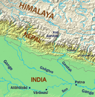
The Gandak ( Hindi गंडक Ganḍak ; also Gandaki ; in Nepal Narayani ) is a left tributary of the Ganges in Nepal and in the Indian states of Uttar Pradesh and Bihar .
The Gandak arises north of Bharatpur at the confluence of its two source rivers Kali Gandaki and Trishuli . It leaves the mountains of the Himalayas and flows in a predominantly south-southeast direction through the northern part of the Ganges plain . In some parts it forms the border between Uttar Pradesh and Bihar . It finally flows into the Ganges at Sonpur . The gandak has a length of about 400 km. The Gandak catchment area covers 46,300 km². The mean discharge is 1760 m³ / s. The runoff can vary between 200 and 400 m³ / s in winter and 15,000 m³ / s in the monsoon season in summer. Floods repeatedly lead to severe devastation along the course of the river.
Web links
Individual evidence
- ↑ a b c Article Gandak in the Great Soviet Encyclopedia (BSE) , 3rd edition 1969–1978 (Russian)


