Bharatpur (Nepal)
| Bharatpur Upmahanagarpalika भरतपुर उपमहानगरपालिका Bharatpur |
||
|---|---|---|
|
|
||
| Coordinates | 27 ° 41 ′ N , 84 ° 26 ′ E | |
| Basic data | ||
| Country | Nepal | |
| Bagmati | ||
| ISO 3166-2 | NP-P3 | |
| District | Chitwan | |
| height | 208 m | |
| surface | 242.3 km² | |
| Residents | 199,867 (2011) | |
| density | 824.9 Ew. / km² | |
| founding | 1979 | |
| Website | www.bharatpurmun.gov.np | |
| City law 2nd order 29 wards |
||
|
Narayanghat
|
||
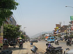
Bharatpur ( Nepali भरतपुर ) is the fifth largest city in Nepal and is located in the Chitwan district .
The city is located in the southern center of Nepal in the Chitwan Valley and is about 146 km from Kathmandu at an altitude of 208 m .
Since December 2nd, 2014 Bharatpur has the city rights of the 2nd order . The neighboring Village Development Committees (VDCs) Fulbari , Gitanagar , Mangalpur , Patihani and Sibanagar were incorporated. The urban area of Bharatpur now covers 242.3 km² (previously 162.2 km²).
Residents
According to the 2011 census, Bharatpur had 143,836 inhabitants (71,175 male) in 36,939 households. Taking into account the VDCs incorporated in 2014, the population increased to 199,867 (97,192 of them male) in 50,449 households.
Sights in the area
- The Chitwan National Park is the third largest tourist destination in Nepal, an important tiger reserve and since 1984 UNESCO World Heritage .
- The Narayani is one of the largest rivers in Nepal; its small islands are a popular destination.
- The Narayangadh district is the city's main shopping and economic center. There are also numerous hotels and restaurants here.
- The Bish-Hazari Lake is located in the south of the city, just 5 kilometers from the city center, in the Chitwan National Park. The lake is a popular destination for bird and crocodile watching.
Climate table
|
Monthly average temperatures and rainfall for Bharatpur
Source: www.weather2travel.com
|
||||||||||||||||||||||||||||||||||||||||||||||||||||||||||||||||||||||||||||||||||||||||||||||||||||||||||||||||||||||||||||||||||||||||||||||||||||||
Web links
Individual evidence
- ^ National Geographic Information Infrastructure Program, Index of Geographical names of Nepal 2007 (p. 3). ( Memento of the original from January 6, 2009 in the Internet Archive ) Info: The archive link was inserted automatically and has not yet been checked. Please check the original and archive link according to the instructions and then remove this notice. (PDF; 73 kB)
- ↑ Municipal Association of Nepal (MuAN) ( Memento of the original from January 7, 2014 in the Internet Archive ) Info: The archive link was inserted automatically and has not yet been checked. Please check the original and archive link according to the instructions and then remove this notice.
- ↑ a b National Population and Housing Census 2011 (PDF) Central Bureau of Statistics. Archived from the original on July 31, 2013.

