
Wiehltalsperre
| Wiehltalsperre | |||||||
|---|---|---|---|---|---|---|---|
.jpg) |
|||||||
|
|||||||
|
|||||||
| Coordinates | 50 ° 56 '8 " N , 7 ° 40' 0" E | ||||||
| Data on the structure | |||||||
| Construction time: | 1967-1973 | ||||||
| Height above valley floor: | 50 m | ||||||
| Height above foundation level : | 53 m | ||||||
| Height of the structure crown: | 295.50 m | ||||||
| Building volume: | 900,000 m³ | ||||||
| Crown length: | 360 m | ||||||
| Crown width: | 8 m | ||||||
| Base width: | 195 m | ||||||
| Slope slope on the air side : | 1: 1.60-1: 2.2 | ||||||
| Slope slope on the water side : | 1: 1.60 | ||||||
| Data on the reservoir | |||||||
| Altitude (at congestion destination ) | 292.50 m | ||||||
| Water surface | 220 ha | ||||||
| Storage space | 31.5 million m³ | ||||||
| Total storage space : | 32.7 million m³ | ||||||
| Catchment area | 46.6 km² | ||||||
| Design flood : | 70 m³ / s | ||||||

The Wiehltalsperre is a dam in the area of the municipality of Reichshof ( Oberbergischer Kreis ) in North Rhine-Westphalia (Germany).
description
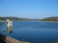
The dam is used for drinking water supply and flood protection and is located about 5 km east of Wiehl . Your storage capacity is at full back about 31.5 million cubic meters at a water surface of approx. 2.2 km².
The reservoir stretches mostly in an east-west direction, its width is between 80 and 500 m, the length is around 6.5 km. From the mid-1960s, around 450 people from the villages of Auchel, Berg, Dresbach, Finkenrath, Hohl, Jägerhaus, Niederodenspiel, Nothausen, Sprenklingen, Strießhard and Ufersmühle had to leave their homes for the construction. The commissioning and start of the water supply from the Wiehltalsperre took place in 1973.
The dam at Ufersmühle dams the water of the Wiehl up to a height of 292.5 m above sea level. NN ( normal traffic jam ) or 293.11 m above sea level. NN ( maximum traffic jam ). It is a rubble embankment with an internal asphalt concrete seal. With the dam water from the Wiehltalsperre and from the Genkeltalsperre , the Aggerverband ensures the drinking water supply in its association area.
An island in the largest of the three pre-barriers of the Wiehl reservoir became known throughout Germany through a TV advertising campaign by the Krombacher brewery .
Tributaries
The main tributary of the Wiehltalsperre is the Wiehl , which is also fed by the Aubach at Wildbergerhütte .
- Wiehl + Aubach from the east, near Nespen at 302 m above sea level. NN .
- Dreschhausen brook from the north, near Nespen.
- Hollow stream from the north.
- Streesharthbach from the south, near Odenspiel .
Viewpoints
In 2005 a lookout point with a picnic area was opened to the population. It is located on the district road K 16 Brüchermühle - Sinspert just before the junction to Schemmerhausen and offers a view of the "Auchel Fjord". A sign posted there provides information about the "sunken villages" in the reservoir.
The Kühlbergturm observation tower south of the dam, built in the 1970s, was demolished in 2013 due to severe damage caused by rot .

Information board about the reservoir

Wiehltalsperre, aerial photo 2020
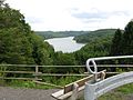
View from the lookout point

Natural dam of the dam
Water extraction tower in the dam
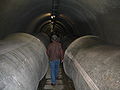
Tunnel in the water intake tower

Wiehltalsperre in winter
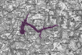
The location of today's Wiehltalsperre on a historical map


natural reserve
The Wiehltalsperre area is located in the Bergisches Land nature park . Until 2014, the area was designated as a landscape protection area.
On September 13, 2014, the landscape plan no. 10 "Wiehltalsperre" of the Oberbergischer Kreis came into force. It covers the southern part of the Reichshof community and replaces previous protected area designations. With this landscape plan was u. a. the 960 hectare nature reserve N 16 Wiehltalsperre redesignated. In addition to the immediate water area of the dam, which is important as a resting and breeding area for birds, large parts of the surrounding forests have also become a nature reserve. In the species and structure-rich deciduous and mixed forests, there are near-natural flowing waters, spring areas and some open land biotopes.


Asbach Valley | Aubachtal and tributaries | Bieberstein-Steinbreche Dreisbachtal and tributaries | Dreschhauser Bachtal and tributaries | Grassland complex west of Spoonsterz | Slopes and valleys near Heikhausen | Heidsiefen and Herzsiefen with adjacent hardwood areas | Kötzel | Deciduous forests at the Mun depot | Mummicker-Siefen | Puhlbruch / Silberkuhle | Sangenberg thorn hedge | Ulbert quarry | Quarry and valley slopes near Bieberstein | Streesharthbach and tributaries | Juniper stands near Wildberg | Juniper area near Branscheid | Wiehlaue Brüchermühle | Wiehltal between Wildbererhütte and Wiehl | Wiehltalsperre
literature
- Peter Franke, Wolfgang Frey: Dams in the Federal Republic of Germany. Published by the National Committee for Large Dams in the Federal Republic of Germany (DNK) and the German Association for Water Management and Cultural Building eV (DVWK). Systemdruck-GmbH, Berlin 1987, ISBN 3-926520-00-0 .
See also
- List of lakes in Germany
- List of dams in Germany
- List of nature reserves in the Oberbergischer Kreis
Web links
- Nature reserve “Wiehltalsperre” in the specialist information system of the State Office for Nature, Environment and Consumer Protection in North Rhine-Westphalia
- World Database on Protected Areas - Wiehltalsperre (English)
- How to get to the Wiehltalsperre ( memento of October 10, 2007 in the Internet Archive ) (PDF; 39 kB)
- Dams directory NRW (PDF; 122 kB)
- Dams in North Rhine-Westphalia; State Environment Agency NRW (PDF; 124 kB)
Individual evidence
- ↑ http://www.aggerverband.de/heute/freizeitendung/55-wandern
- ↑ https://www.ltur.com/de/lounge/news/Die-Krombacher-Insel-besuchen?cid=NL_3172_34
- ↑ Google Maps. Retrieved May 25, 2019 (de-US).
- ↑ The Kühlbergturm will fall in Oberberg-aktuell from April 4, 2013, accessed on December 19, 2015
- ↑ a b Public announcement: Implementation of the notification procedure according to § 28. In: www.oberbergischer-kreis.de. September 13, 2014, accessed March 14, 2015 .
- ↑ a b c "Wiehltalsperre" nature reserve. (PDF) In: Landscape plan No. 10 Wiehltalsperre - statutes of the Oberbergischer Kreis. April 3, 2014, p. 81 , accessed March 14, 2015 .