
Aubach (Wiehl)
|
Aubach The Au |
||
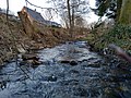
 The Aubach near the Weiherdamm in Wildbergerhütte |
||
| Data | ||
| Water code | DE : 2728414 | |
| location | Germany | |
| River system | Rhine | |
| Drain over | Wiehl → Agger → Sieg → Rhine → North Sea | |
| source | at the hedgehog pond 50 ° 55 ′ 0 ″ N , 7 ° 44 ′ 8 ″ E |
|
| Source height | 414 m | |
| muzzle | in Wildbergerhütte in Wiehl Coordinates: 50 ° 56 '25 " N , 7 ° 44' 54" E 50 ° 56 '25 " N , 7 ° 44' 54" E |
|
| Mouth height | 311 m | |
| Height difference | 103 m | |
| Bottom slope | 24 ‰ | |
| length | 4.2 km | |
| Catchment area | 8.543 km² | |
| Discharge A Eo : 8.543 km² at the mouth |
MNQ MQ Mq |
19.99 l / s 221.67 l / s 25.9 l / (s km²) |
| Left tributaries | Mohrenbach | |
| Right tributaries | Schönbach , Wildberger Bach | |
| Reservoirs flowed through | Flood retention basin in the Aubach valley | |
| Communities | Reichshof | |
The Aubach is a 4.2 km long, southern and left tributary of the Wiehl in the district Wildbergerhütte belonging to the municipality of Reichshof in the North Rhine-Westphalian Oberbergische Kreis .
Origin of name
The name Aubach comes from the term floodplain (Auwald), which describes the natural plant community along streams and rivers. The hiking area Aubachtal was named after the Aubach in Wildbergerhütte . The Aubach is popularly known as "The Au".
geography

source
The Aubach source is located north of Wendershagen , at the Heckenweiher at about 414 m above sea level. NN , on the eastern edge of the Bergisches Land nature park , directly on the district and state border with the Altenkirchen district and Rhineland-Palatinate .
course

The Aubach initially flows north-west until it joins the approximately 1 km long Mohrenbach not far from Erdingen and swings to the north-east. In the Pfänderwiese, another tributary flows into the Aubach from the left. Further north, the Aubach reaches the Aubach valley .
The right source stream , also called Schönbach , is about one kilometer long. It rises in Schönbach in the Rhineland-Palatinate area at about 395 m above sea level. NN . It continues in a north-easterly direction until the Aubach reaches Wildbergerhütte , where it joins the approx. 1.8 km long Wildberger Bach . It rises in Wildberg at about 382 m above sea level. NN and is additionally fed by the approx. 1.2 km long Langenbach . The Aubach swings to the northwest and reaches the center of Wildbergerhütte along the Weiherdamm . At about 311 m above sea level. NN opens the Aubach to 3.2 km (4.2 km by Möhrenbach) at the sports ground in Wildbergerhütte in Wiehl .
- Impressions from the Aubach

Aubach (Wiehl)

Aubach near the Weiherdamm

The Aubach near the source
Aubach at a very low water level
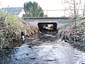
The underpass of the Aubach under the main road

Aubach in the forest (Aubachtal)

The Aubach in a forest clearing on the upper reaches


.jpg)

drainage
After the Aubach joins Wildbergerhütte in Wiehl, this feeds the 1.5 km east Wiehltalsperre . The Wiehl runs from the dam further east through Wiehl in the Oberbergischer Kreis and flows into the Agger at Wiehlmünden . This flows through Engelskirchen and turns its course to the south-west, towards Lohmar and continues south of Cologne / Bonn Airport . In Siegburg the Agger flows into the Sieg , that opens about 8 km southwest in Bonn in the Rhine . Another 250 km north-west as the crow flies , the Rhine flows into the North Sea in the Rhine-Maas Delta .
Tributaries
The largest tributaries of the Aubach from the source to the mouth are:
- Mohrenbach (1 km, left) near Erdingen at 370 m above sea level. NN .
- Schönbach (1 km, left) in the Aubachtal at 357 m above sea level. NN .
- Wildberger Bach (1.8 km) / Langenbach (1.2 km, right) at Wildbergerhütte at 317 m above sea level. NN .
Rhine river system
The Aubach in Wildbergerhütte is a tributary of the Wiehl and belongs to the Rhine system .
Hydrology
_im_Aubach_bei_Wildbergerh%C3%BCtte.jpg)
Flood
On May 3, 2001 , after torrential rains, there was a flood known as the flood of the century (warning level 4). Between 4 p.m. and 8 p.m., 110 liters of rain fell per square meter. The monthly average in NRW is only 100 liters.
Low tide
During the drought and heat in 2018 , there was an unusually low water level in the Aubach due to weeks of drought .
Aggerverband / flood protection
The Aggerverband (based in Gummersbach ) takes care of the maintenance of the flowing waters and the flood protection of the Aubach. Flood risk and hazard maps are created (see web links) to ensure that flood information is improved. In addition, alarm, evacuation and deployment plans are drawn up.
Flood retention basin
Due to recurring flood damage, a flood retention basin was built in the Aubachtal in the Mähhainwiese to regulate the flow rate in the direction of the Wildbergerhütte during floods .
Risk waters of NRW
The Aubach is one of the water bodies at risk in North Rhine-Westphalia, especially in the last 200 meters before the Wiehl estuary near the Weiherdamm , during an extreme flood ( warning level 4, flood defense ), embankments can occur that also affect part of the building .
nature and environment
Bergisches Land nature reserve / Wiehltalsperre nature reserve

The Aubach is located in the middle of the Bergisches Land nature park and touches the deciduous forests nature reserve at the ammunition depot , which has been designated since April 2014 and, among other things, offers a habitat for bats such as the great mouse-eared bats in the upper reaches . Due to the drainage in the drinking water reservoir Wiehltalsperre , which is located in the largest nature reserve of the Oberbergischer Kreis and whose immediate water area is important as a resting and breeding place for birds, as well as a habitat for beavers and otters, great importance is attached to preserving the habitat of flowing waters in the Aubach and protect. The Reichshof municipality and the Aggerverband succeed in doing this with regular controls and the restoration of near-natural habitats, among other things in order to comply with the EU water framework guidelines. In addition, care is taken to ensure that no pollution or foreign bodies get into the water in order to protect and maintain the Wiehltalsperre nature reserve.
flora
- Flora on the Aubach
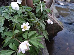
Big anemone in April

Black alder

Little evergreen

Fern near the Weiherdamm


The vegetation on the banks of the Aubach changes in the course of the river. The upper course in the Aubach valley is characterized by dense, shady forests, under which only a sparse layer of herbs can develop. The middle reaches are characterized by alder and willow species, but also the glandular balsam and neophytes such as the Japanese knotweed can be found again. Furthermore, wild perennials can be found on the banks of the Aubach, such as the great anemone or the lesser celandine .
Web links
- Course of the Aubache according to the specialist information system ELWAS, Ministry for Climate Protection, Environment, Agriculture, Nature and Consumer Protection NRW ( notes )
- Longitude and Latitude on: Longitude and Latitude / GPS coordinates
- River system and survey on: BORISplus , NRW
- To the Aggerverband: https://www.aggerverband.de/
- Flood protection on the Aubach: https://www.flussgebiete.nrw.de/system/files/atoms/files/2728414_aubach_a00_rk_hw_b001.pdf
Individual evidence
- ↑ a b Water directory of the State Office for Nature, Environment and Consumer Protection NRW 2010 (XLS; 4.67 MB) ( Notes )
- ↑ Modeled discharge values according to the specialist information system ELWAS, Ministry for Climate Protection, Environment, Agriculture, Nature and Consumer Protection NRW ( notes )
- ↑ Vegetation zone: alluvial forest. Retrieved June 3, 2019 .
- ↑ measurement (height). In: Google Earth. Retrieved March 30, 2019 .
- ^ Map Möhrenbach-Aubach. In: Boris NRW. Retrieved March 30, 2019 .
- ↑ Measurement (length). In: Boris NRW. Retrieved March 30, 2019 .
- ↑ measurement (height). In: Google Earth. Retrieved March 30, 2019 .
- ↑ Measurement (length) - mouth. In: Boris NRW. Retrieved March 30, 2019 .
- ↑ measurement (height). In: Google Earth. Retrieved March 30, 2019 .
- ↑ TIM-online. Retrieved May 19, 2019 .
- ^ Tributaries of the Aubach. (PDF) In: HWRK (Aubach flood risk map). Retrieved March 30, 2019 .
- ^ Tributaries of the Aubach. (PDF) In: HWRK (Aubach flood risk map). Retrieved March 30, 2019 .
- ↑ tributaries Wildberger Bach, Langenbach. Retrieved April 11, 2019 .
- ↑ Reiner Thies: Flood of 2001: When the flood came over Oberberg. June 3, 2016, accessed on May 19, 2019 (German).
- ↑ mdr.de: Heat over Europe: Maps show terrifying consequences of the drought | MDR.DE. Retrieved May 19, 2019 .
- ↑ Flood information . Retrieved May 19, 2019 .
- ↑ Action planning for Reichshof. (PDF) Retrieved May 19, 2019 .
- ↑ BORISplus.NRW - Official information on the real estate market. Retrieved June 3, 2019 .
- ↑ Flood in front of the Wiehl estuary. (PDF) In: Profile of the municipalities 2015. Accessed on May 19, 2019 .
- ^ Deciduous forests nature reserve at the ammunition depot. (PDF) Retrieved June 3, 2019 .
- ↑ Oberberg's largest nature reserve. Retrieved June 3, 2019 .
- ↑ Oberberg's largest nature reserve. Retrieved June 3, 2019 .
- ↑ Agger Association. Retrieved June 3, 2019 .
- ↑ Planning of the Bergisches Land Aubach Nature Park. (PDF) Retrieved June 3, 2019 .