
Wiehl
| coat of arms | Germany map | |
|---|---|---|

|
Coordinates: 50 ° 57 ' N , 7 ° 32' E |
|
| Basic data | ||
| State : | North Rhine-Westphalia | |
| Administrative region : | Cologne | |
| Circle : | Oberbergischer Kreis | |
| Height : | 191 m above sea level NHN | |
| Area : | 53.26 km 2 | |
| Residents: | 25,161 (Dec. 31, 2019) | |
| Population density : | 472 inhabitants per km 2 | |
| Postal code : | 51674 | |
| Primaries : | 02262, 02261 (Alferzhagen, Bomig, Marienhagen, Merkhausen) , 02296 (Angfurten, Bieberstein, Dreisbach partly, Remperg) | |
| License plate : | GM | |
| Community key : | 05 3 74 048 | |
| LOCODE : | DE WHL | |
| City structure: | 52 districts | |
City administration address : |
Bahnhofstrasse 1 51674 Wiehl |
|
| Website : | ||
| Mayor : | Ulrich Stücker (independent) | |
| Location of the city of Wiehl in the Oberbergisches Kreis | ||
  |
||

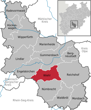
Wiehl is a town in the Oberbergisches Kreis in the administrative district of Cologne in North Rhine-Westphalia ( Germany ).
geography
Location

Wiehl is about 41 km east of Cologne as the crow flies . The neighboring communities border the city (starting clockwise from the north) Gummersbach , Reichshof , Nümbrecht , Much and Engelskirchen . Between the A4 motorway and Wiehl lies Wiehl's largest industrial area with around 81 hectares: Wiehl- Bomig . The Wiehl river of the same name flows through the city in an east-west direction.
| Gummersbach | Bergneustadt | |
| Engelskirchen |
.svg)
|
Reichshof |
| Much | Nümbrecht | Waldbröl |
City structure

| A. | Alferzhagen - Alpe - Alperbrück - Angfurten |
| B. | Bieberstein - Bielstein - Börnhausen - Bomig - Brächen - Breidenbruch - Büddelhagen - Büttinghausen |
| D. | Dahl - Drabenderhöhe - Dreisbach - Drosselhardt |
| F. | Fahlenbruch - Faulmert - Forst |
| G | Gassenhagen - Großfischbach |
| H | Hahn - Hau - Hengstenberg - Hillerscheid - Hübender - Hückhausen |
| I. | Immen |
| J | Jennecken |
| K | Kleinfischbach - Kurtensiefen |
| L. | Linden trees |
| M. | Marienhagen - Merkausen - Monsau - Morkepütz - Mühlen (Wiehl) on the Bech - Mühlhausen |
| N | Neuklef - Niederbellinghausen - Niederhof |
| O | Oberbantenberg - Oberholzen - Oberwiehl |
| P | Pergenroth - Pfaffenberg |
| R. | Remperg |
| S. | Steinacker |
| V | Verr |
| W. | Forest - Weiershagen - Wiehlsiefen |
In addition, there were over 30 old place names, which were abandoned at different times and for different reasons and are now preserved and recognizable in street names:
- Alpermühle, Koppelweide , Pergenroth , Seifen (now part of Marienhagen)
- Breidenbruch (to Bomig)
- Altklef, Bruch, Dahl, Dörnen, Nürsche, Ohl, Puhl, Zaun, Zirre, Wülfringhausen (to Wiehl)
- Atzenhagen (to Hübender)
- Heckelsiefen, Mühlenau, Perke, Scheidt, Siefen, Soelsiefen (to Oberwiehl)
- Neuenhaus (to Alpe)
- Damte, Dreibholz, Helmerhausen, Kehlinghausen, Mühle, Repschenroth, Unterbantenberg (to Bielstein)
- Chicken mill (to cock)
- Reuschenbach, Kleebornen, Steeg, hut, pastures (to Weiershagen)
- Scheidt (to Drabenderhöhe).
The disclosure of historical settlement names, mostly recorded in the Mercator map of 1575, began as early as 1901/02 with the renaming of the former Drabenderhöhe community to Bielstein (Rheinl.), Which was previously called Repschenroth in the core. Weiershagen followed in 1912 as a collective name for a number of scattered settlements. As a result of brisk construction activity and rapid population growth, further structural mergers took shape in the development phase after the Second World War , especially around the main town of Wiehl. The elimination of many place names combined with the widespread introduction of street names went hand in hand with the municipal regional reform in 1969 (union of the communities Wiehl and Bielstein) and the urbanization documented for the city development (1971) . Last but not least, the reason for this was also postal requirements following the introduction of postcodes.
history

In 1131 Wiehl was first mentioned in a document under the name Wila . It is recorded as Wiell on the Mercator map from 1575 . As a result of the Siegburg settlement of 1604, Wiehl was finally added to the Homburg rulership and thus placed under the Sayn-Wittgenstein family . In 1815 the Congress of Vienna assigned the Homburg area, which practically consisted only of the communities Wiehl and Nümbrecht , to Prussia . At that time Wiehl was still an agricultural place with a rural character, whose excess population had to be fed by migrant work. It was not until the use of the Wiehl's hydropower by the Ohler Hammer since 1860 and electricity generation since 1895, the connection to the railway network in 1897 and the establishment of the Bergische Patentachsenfabrik Wiehl (BPW) in 1898 that the prerequisites for increased population growth were created. The National Socialism left Wiehl a new town hall (today the old one). After the Second World War, Wiehl integrated the influx of bombed out and displaced persons. Through the regional reform , the community was united on July 1, 1969 with Bielstein (including Drabenderhöhe ) and parts of the area of Denklingen (Reichshof) . Bielstein and Wiehl, however, also lost areas, especially with densely populated places in the Aggertal, to Gummersbach. Ründeroth was enlarged by areas of Bielstein, Reichshof by areas of the old community Wiehl. The new community was in 1971, the city charter , so 840 years after its first mention. Since then it has enjoyed solid and steady growth , also thanks to the influx of resettlers and a clever industrial policy.
Population development
Before the territorial reform on July 1, 1969
In the First World War 1914–1918, 157 Wiehlers and 169 Bielstein citizens died.
|
|
|

After the territorial reform on July 1, 1969
With the municipal territorial reform that came into force on July 1, 1969, the territorial status of the independent communities Wiehl and Bielstein ended. In terms of figures, the new community Wiehl explains a considerable decrease compared to the previously added community residents of the old communities Bielstein and Wiehl. Occasionally noticeable declines are also based on statistical adjustments to the resident registration files (deletion of second homes, etc.).
|
|
|
|
|
politics

City council
The city council of Wiehl has 36 seats since the local elections on May 25, 2014 . Since then, the seats have been distributed among the individual parliamentary groups as follows:
| Political party | CDU | SPD | FDP | GREEN | UWG | LEFT | total |
| Seats | 13 | 13 | 2 | 3 | 3 | 2 | 36 |
| G / V * | - 1 | + 2 | - 2nd | ± 0 | ± 0 | + 1 |
* Gains or losses compared to the previous 2009 election
coat of arms
The coat of arms of the Homburg rulership of the princes of Sayn-Wittgenstein served as the basis of today's Wiehl coat of arms. The official description reads: "In red a silver (white) gate castle with a high three-lined pinnacle tower on the right and a low two-lined crenellated tower with a blue dome on the left." The pointed gabled gatehouse has a window over a red, with gold (yellow) Portcullis filled doorway. It consists of a two-tower castle with an open gate and portcullis. A silver (white) St. John's Cross hovers over the low tower . This cross is intended to remind that the Johanniterkommende existing in Marienhagen (Wiehl) had the patronage of the then not yet independent chapel in Drabenderhöhe and the associated buildings. The coat of arms arrangement was adopted on July 1, 1969 when the communities Wiehl and Bielstein merged from the Bielstein coat of arms, supplemented by the cross and approved on April 17, 1972.
Town twinning
- Jokne'am, Israel (partnership agreement 1991)
In 1972, the first contacts between the Jokne'amer trade unionist Moshe Amos and the then city director Dr. Dieter Fuchs quickly found a casual friendship. The visit of a tour group from Wiehl in October 1973 had to end prematurely because of the turmoil and dangers of the Yom Kippur War that suddenly broke out . In 1974 a soccer team from Yokneam made a return visit to Wiehl. Further visits on a private level as well as official tour groups followed. In 1980 the Freundeskreis Wiehl-Yokneam was founded under the chairman G. Hermann, in 1981 the partnership agreement was signed.
- Hem, France (partnership agreement 1993)
First visiting contacts between official representatives from Wiehl and the city of Hem in the French part of Flanders , not far from Lille / Roubaix, took place in 1991. A year later, a delegation from Wiehl visited Hem's schools and associations. In 1992 a joint partnership committee was founded with the task of promoting encounters between young and old of all population groups. Above all, exchange measures between schools and interns were supported. Mutual visits by youth groups, associations, individuals and families strengthened contacts. In 1993 and 1994, official celebrations for the signing of the partnership certificate took place in Wiehl and Hem. In 1995 the “Franco-German Partnership Association Wiehl / Hem” was founded in Wiehl, which, together with the “Comitė de Jumelage” Hem Ville d'Europe, coordinates and promotes the partnership activities with the aim of international understanding.
- Crimmitschau, Saxony
Soon after the fall of the Berlin Wall on November 9, 1989 and the opening of the inner-German border, Wiehl received a visit from a three-person delegation from the Saxon city of Crimmitschau an der Pleiße in the first days of February 1990 . "We want to pave the way and build a bridge" - the interviewees in Wiehl town hall agreed on this. The then city councilor Reinhold Ley initiated the first contacts after visiting relatives. Just a few days later, a delegation from Wiehl with top representatives from the council and administration set out on a return visit to the GDR in order to prepare the ground for the desired town twinning. Working groups on the subjects of “industry and trade” and “local self-government” have been set up. This was followed by a lively exchange of ideas and experiences during numerous human encounters, and lasting friendships were made. The small Saxon town experienced a real rush of visitors from the Homburg region. Around 250 Wiehlers wanted to be there when the partnership agreement was ceremoniously signed on March 24, 1990 in Crimmitschau. The basis for a fruitful cooperation was laid, not only at the municipal level, but also for trade, craft, industry, gastronomy and, last but not least, for contacts between the clubs in the areas of sport and culture.
Culture and sights
nature
The Wiehler stalactite cave is a walk-in show cave. It has around 20,000 visitors annually.
Buildings


The Protestant church in the heart of Wiehl is the largest of the Wiehl churches, a previous building was built around 700. In the upper village there is a listed and restored half-timbered ensemble with houses from 1755. The "mill bridge", which was built in 1650 and renovated in 1980, runs over the small river Wiehl on the edge of the old town center. The Bismarck Tower is an observation tower that was built in 1909 during the imperial era. It is 16.8 meters high, has a regular hexagonal floor plan and was built from greywacke . The town hall from 1939 embodies the concept of homeland security architecture at the time .


In the Marienhagen district there is one of the so-called Bunter Kerken , a church with medieval ceiling paintings. Also worth seeing is the still growing family of roundabouts with which Wiehl surrounds itself and each of which illuminates a special aspect of Wiehl's economic history (see gallery). The Wiehltalbahn is also a listed building . The Weiher-Arkaden building complex has rounded off the commercial and residential development on Weiherplatz since 2006.
Monuments
A war memorial with a soldier statue stands on the edge of the city park below the church. There are memorial plaques in the wall listing the names of the fallen soldiers. In addition, a text excerpt from a speech by former Federal President Richard von Weizsäcker was attached. In Oberwiehl, across from the Oberwiehl primary school, there is a memorial to the fallen German soldiers of the First World War.


Another war memorial stands above the Protestant church in Wiehl-Bielstein. It was moved from its original location near the pedestrian overpass with the construction of the bypass. (Source: Bielstein in old pictures)

The entire Wiehltalbahn is also under monument protection.
Museums
The “Axle, Wheel and Carriage” museum in Wiehl-Ohlerhammer presents the 5,500-year history of vehicle construction on an exhibition area of over 1,000 m². It was reopened on October 27, 2013 after extensive renovations. In the idyllically situated farm museum in Monsau , old agricultural tools and machines are exhibited. Another museum is located in the Drabenderhöhe district . The Museum Siebenbürger Heimatstube Drabenderhöhe in the Kulturhaus exhibits, among other things, traditional costumes and household items and provides insights into the customs of the over 800-year-old tradition and culture in the Transylvanian region.
Sports
- Ice rink Wiehl
The Wiehl ice rink in Mühlenstraße near the train station near the center is one of a total of 30 artificial ice rinks in North Rhine-Westphalia . It is always open in the winter months (approximately from September to April). The ice rink can be used as a public ice rink for an entrance fee.
The ice rink was completed together with the new outdoor swimming pool in 1976 as a large-scale test facility for the use of solar energy. The RWE participated also in this project, which had among other objectives, to test new ways to produce hot water.
In addition to ice skating, ice hockey and curling are played in the sports hall . As an ice hockey club in the Association of North Rhine-Westphalia, TuS Wiehl is a guest and user of the hall; the sport of curling is organized by the Curling Club Wiehl (CC Wiehl). During the summer months, for example, the hall is used for concerts and markets.
- Wiehltalstadion
The Wiehltalstadion is a sports stadium. It could be used by national teams during the 2006 World Cup. In this regard, a contract was signed on August 4, 2004 between FIFA and the city of Wiehl. In 2005 the lawn was completely renovated. The grass pitch has a size of 105 × 86 meters and holds a maximum of 5,000 spectators. A changing building with 3 changing rooms and 2 shower units is available. The facility is completely fenced in and has a privacy screen in the form of dense green vegetation. Furthermore, the facility has an artificial turf field measuring 43 by 35 meters. It can be used for soccer, basketball, volleyball and soccer tennis, and this area is also completely fenced.
- Eichhardt sports field
The Eichhardt sports field, meanwhile renamed Walter-Lück-Sportanlage , is a centrally located artificial turf field with a small artificial turf outdoor playing field in Wiehl. It is located directly at the Wiehl Nature Park, not far from the town hall and the Protestant church. It is the home of the largest Wiehler football club FV Wiehl 2000 e. V. currently has 22 youth and 5 senior teams. In 2010, the Siegward Tesch grandstand for 500 spectators with changing and shower rooms was built on the site.
- Other sports facilities
- Sports and gymnasiums at high school and primary school
- Solar outdoor pool with slide and 50 m long run suitable for competitions
- Sauna, Kneipp facility
- Wiehlpark for leisure, games and sports
- Balloon launch site in Wiehlpark, see also: Bergische balloonists
Regular events
- Weekly market on Wednesday.
- Heimatfest at the Bismarck Tower ("Türmchenfest"; beginning of June).
- City festival (the first weekend in July).
- Christmas market on the 2nd Advent
- The International Wiehler Jazz Days , which enjoyed great attention in the jazz scene, took place regularly and a total of 25 times from 1989 to 2014. Jazz greats like Lillian Boutté , Al di Meola , Götz Alsmann , Lyambiko , Melva Houston , Albie Donnelly 's Supercharge, Louisiana Red and many others performed in Wiehl. The event will no longer take place because there were too few sponsors and the number of visitors also decreased.
- At the Wiehl Dahlia Show , which took place for the last time in over 60 years, in 2016, hundreds of different types of dahlias could be viewed from August to October .
Economy and Infrastructure
Iron mining and processing has been in operation in Wiehl since the late Middle Ages . Until the last century, the extraction and processing of the greywacke was an important economic and commercial branch.
Business parks and service centers
GG = commercial area, DL = service center, AS = junction
- GG Bielenstein : ha 34.1 L 336, local Helmershausen 2.5 km to the AS 24 of the A 4
- GG Bomig -West: 48.8 ha, at the traffic intersection ; -Ost: 20.3 ha, Albert-Einstein -Straße and -Nord: 11.5 ha, Carl-Zeiss-road : 80.6 ha together is between 1 and 2 km to the AS 25 of the A 4
- GG Drabenderhöhe : 7.6 ha, industrial site , 6 km to the AS 24 of the A 4
- DL Service Center Heckelsiefen (Oberwiehl): 2.5 ha, L 336, Oberwiehl , 8 km to the AS 25 of the A 4
- GG Marienhagen : 20.1 ha, Vor den Birken , 5 km to AS 25 of the A 4 . In the Marienhagen industrial area, which was enlarged in 2005, more companies are located. The most important settler is a modernized die-casting plant that has been relocated from Bielstein.
- GG Mühlen : 6.8 ha, L 95, 6 km to AS 24/25 of the A 4
- GG Oberbantenberg : 3.1 ha, district Am Faulenberg , 2.5 km to the AS 25 of the A 4
- DL Service Center Oberbantenberg : 2 ha, K 52, 2 km to AS 25 of the A 4
- GG Oberwiehler industrial park: 4.2 ha, Derschlager Straße , 8 km to AS 25 of the A 4
- GG Sengberg ( Oberwiehl ): 3.3 ha, Derschlager Straße , 9 km to the AS 25 of the A 4
- GG Weiershagen : 3.7 ha, B 56, exit from town, 2.5 km to AS 24 of the A 4
- GG Wiehl-Ohlerhammer: 29.4 ha, near the center of Wiehl, 7.5 km to AS 25 of the A 4
Established businesses
The largest employer in Wiehl is the BPW Bergischeachsen limited partnership with over 1900 employees. Merten's main plant and the development center of the French Schneider Electric group , which Merten took over in 2006, are also located here.
traffic
Wiehl is on the federal motorway 4 ( Cologne - Olpe ).
Rail transport

Wiehl is connected to the railway network by the Wiehl Valley Railway . It was reactivated in 1999 by a support group. Steam trains run here on the first Sunday of April to October. In the summer of 2005, the public rail freight station in Wiehl was reopened, shortly afterwards freight traffic resumed. So far, mainly wood has been transported. The municipalities along the route wanted to demolish the railway line due to various road construction plans, which is why they bought the line at the end of 2006 with the help of an interest-free loan from the State Office for Road Construction. A bitter dispute arose between the support group and regional politics, which was noticed throughout Germany due to its choice of words, as the then State Transport Minister Oliver Wittke described the Wiehl Valley Railway as a " stair joke ".

In January 2007, the Cologne Administrative Court ruled in favor of the operators, so rail traffic was initially secured. Regardless of this, the city of Wiehl applied in May 2007 for exemption from railway operations, which the Cologne district government granted in February 2008. In July 2008, the Higher Administrative Court of Münster obliged the state of North Rhine-Westphalia to issue a long-term operating license for the Wiehl Valley Railway, which was issued in August 2008 and is valid until 2056. In November 2008 the Cologne Administrative Court ruled that the demedication of parts of the Wiehl Valley Railway, which had taken place in the meantime, was unlawful and revoked the notices to exempt the railway property from operational purposes.
Bus transport
The following bus connections of the Oberbergische Verkehrsgesellschaft (OVAG ) exist in the Verkehrsverbund Rhein-Sieg (VRS):
- 302: Gummersbach - Wiehl - Nümbrecht - Waldbröl
- 304: Gummersbach - Wiehl - Denklingen - Morsbach
- 306: Gummersbach - Rospe - Dieringhausen - Hunsheim - Wiehl
- 321: Wiehl - Volkenrath - Eckenhagen
- 324: Wiehl - Marienberghausen - Nümbrecht
- 325: Wiehl - Mühlhausen - Bomig - Dieringhausen
Hiking and biking trails
See also: Hiking trails in the Oberbergisches Land
As in the entire Bergisches Land, almost all hiking trails come from the Sauerland Mountain Association. V. (SGV) .
- The R20 cycle path runs through Wiehl in an east-west direction.
- The R33 cycle path runs through Wiehl in a north-south direction.
education
Schools and educational institutions
- Community elementary school Wiehl
- Community elementary school Bielstein
- Community elementary school Drabenderhöhe
- Community elementary school Marienhagen
- Community elementary school Oberwiehl
- Free Christian Elementary School Wiehl
- Dietrich Bonhoeffer Grammar School
- All-day secondary school Bielstein "Vocational school for technology", former community secondary school Bielstein
- Bielstein secondary school
- Helen Keller School
- Hugo Kükelhaus School
- School for the speech impaired
- Wiehltalhalle - auditorium of the grammar school for events of all kinds
- Music school of the Homburg communities e. V.
- Kreisvolkshochschule department Wiehl
- City library
- Kulturkreis Wiehl e. V.
Other social institutions
- 1 municipal and 2 church kindergartens
- Waldorf kindergarten
- Municipal youth meeting in the Bions camp
- Evangelical House of Youth
- Youth café "Checkpoint"
- Youth Hotel (Youth Hostel)
- OASe Open Work for Seniors
- Retirement and nursing home " Bethel "
- Diakonie and Johanniter social station
- Johanniter Accident Aid
Parishes
- Ev. Parish Wiehl
- Catholic parish Wiehl
- Evangelical Free Church in Wiehl
- Church for Oberberg - Wiehl
Personalities
sons and daughters of the town
- August Kind (1824–1904), architect, construction clerk, head of the building administration of the Reichspost 1875–1889
- Wilhelm Idel (1849–1927), local researcher and poet: The bells of Wiehl
- Johannes Jüngst (1871–1931), evangelical clergyman and author, born in Drabenderhöhe
- Emil Forst (1877–1971), farmer and politician born in Hückhausen
- Max Deubel (* 1935), motorcyclist
- Emil Hörner (1937–2003), motorcyclist
- Jan-Frederick Göhsl (* 1993), football player
Lived here at times
- Friedrich von Bömches , painter, had lived here since 1978
- Eugen Daub , painter, worked here from 1970 to 1992
- Johannes Popitz , politician and activist in the resistance against National Socialism, headed the administration in Wiehl for a short time in 1909
- Horst Waffenschmidt , CDU politician, city director in Wiehl from 1964 to 1972
- Stefan Kretzschmar , former national handball player, lived in Kleinfischbach from 1993 to 1996
- Karl-Heinz Feldkamp , soccer coach
- Ruth Hallensleben , industrial photographer , lived in Wiehl from 1943 to 1961
- Christian W. Schenk , poet, lived in Wiehl from 1976 to 1977
Others


- Weddings are held regularly 30 meters below ground by the Wiehl registry office in the Wiehl stalactite cave .
- In a game reserve near the stalactite cave, red, Sika, fallow, mouflon and wild boar can be observed.
- From May to the end of October, trips between Wiehl and Nümbrecht can be made in the historic Oberbergische Postkutsche , a replica of the Imperial Post's post coach from May to the end of October.
- Forest and nature trail: A 1.8 kilometer circular trail that begins next to the entrance to the stalactite cave.
- In Siefen below the stalactite cave there is the mining -archaeological ground monument Goldener Trog , an old mine tunnel that was used to mine iron ore and extended in branched mine fields to below the villages of Hübender, Pfaffenberg and Abbenroth (municipality of Nümbrecht). Mining has been going on since at least the beginning of the 19th century, and finally mining was stopped in 1912 because the ore was insufficient. Later, the tunnel served as the Wiehler water supply for decades. At the restored masonry tunnel entrance, the temporarily lost stone with the carved inscription: Golden Trough was re-erected in 1813 .
- The Wiehltalsperre is located about 6 km east of Wiehl .
- During the final round of the 2007 handball world championship , the German team stayed at the Hotel zur Post. On the day of the final, the future world champions were bid farewell by thousands of fans.
literature
Books
- Wilfried Bergerhoff, Ulrich Runkel (ed.): My Wiehl. History and stories of a city. Citizens write on their 875th birthday. Gronenberg, Wiehl 2006, ISBN 3-88265-258-6 .
- Gottfried Corbach: Contributions to the Bergische history. Scriba-Verlag, Cologne 2001, ISBN 3-921232-48-1 (reprint of the 1976 edition).
- Heimatverein Wiehl (ed.): 850 years Wiehl 1131–1981. Festschrift for the 850th anniversary of the city of Wiehl. Heimatverein Wiehl, Wiehl 1982.
- Otto Kaufmann : The Homburg region in the Thirty Years War (= issue of old descriptions of homeland. 24). Raiffeisenbank Nümbrecht, Nümbrecht 1983.
- Siegfried Lauff: Wiehl through the ages. 3 volumes. MD & V Meinerzhagener Druck- und Verlag-Haus, Meinerzhagen 1977–1990, ISBN 3-88913-150-6 .
- Ulrich Melk: Chronicle of Wiehl. (Old communities Wiehl and Bielstein or Drabenderhöhe). 1131-1920. Heimatverein Wiehl, Wiehl 2001, ISBN 3-00-008600-5 .
- Klaus Pampus: First documentary mentions of Oberbergischer places (= contributions to Oberbergischen history. Special vol. 1). Oberbergische Department 1924 eV of the Bergisches Geschichtsverein, Gummersbach 1998, ISBN 3-88265-206-3 .
- Dietrich Rentsch: Oberbergischer Kreis. Volume 2: Marienheide - Wiehl (= monuments of the Rhineland. Vol. 11, ISSN 0070-3427 ). Schwann, Düsseldorf 1967.
- Hans Joachim Söhn, Lothar Wirths (arr.): Oat feed label. Inhabitants and fireplaces in the Homburg rulership in 1580 (= materials and sources on Oberberg regional history. Issue 3). Galunder, Gummersbach 2003, ISBN 3-89909-012-8 .
- Torsten Sülzer: From the village well to the waterworks. The history of water management at Agger - Wiehl - Bröl. Gronenberg, Wiehl et al. 1998, ISBN 3-88265-207-1 .
brochures
- Joachim Kleinmanns: Wiehl-Marienhagen. Rhenish Association for Monument Preservation and Landscape Protection e. V. Neuss 1987, ISBN 3-88094-571-3 .
- Karl Simon: The Oberbergische Kreis. A local reading and work book for school. With the collaboration of Josef Breuer and Fritz Mylenbusch. City of Gummersbach, Gummersbach 1968.
Postcards
- Wiehl with his surroundings. Manufacture and publisher Schöning & Co.
The Wiehler roundabout

Dahlia roundabout Wiehl
Bahnhofstrasse / Brucher Strasse / Homburger Strasse station
Grauwacke spinning top
L 336 / L 350
Forge
hammer-top K 48 / L 336
Slate
lorry top L 350 / L 95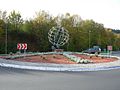
World axis gyro
L 336 / Ohlerhammer
Half-timbered roundabout
L 350 / L 320


Web links
- History of the Homburg communities Wiehl and Nümbrecht ( Memento from December 27, 2014 in the Internet Archive )
- History of the Merkausen district of Wiehl
Individual evidence
- ↑ Population of the municipalities of North Rhine-Westphalia on December 31, 2019 - update of the population based on the census of May 9, 2011. State Office for Information and Technology North Rhine-Westphalia (IT.NRW), accessed on June 17, 2020 . ( Help on this )
- ^ Martin Bünermann: The communities of the first reorganization program in North Rhine-Westphalia (= Kommunale Schriften f. North Rhine-Westphalia . Volume 32 ). Deutscher Gemeindeverlag, 1970, ISSN 0454-2584 , p. 81 .
- ^ City of Wiehl - numbers and facts
- ^ City of Wiehl - elections
- ↑ http://www.bkge.de/Heimatsammlungen/Ververzeichnis/Herkunftsgebiete/Siebenbuergen/Drabenderhoehe.php
- ^ Oberberg-Online Informationssysteme GmbH: Oberberg-Aktuell - Archive News - Detail. Retrieved July 27, 2017 .
- ↑ Harald Knoop: After more than 60 years: Wiehler Dahlia Show takes place for the last time . In: Kölnische Rundschau . ( rundschau-online.de [accessed on July 27, 2017]).
Bergneustadt | Engelskirchen | Gummersbach | Hückeswagen | Lindlar | Marienheide | Morsbach | Nümbrecht | Radevormwald | Reichshof | Waldbröl | Wiehl | Wipperfürth