Alpe (Wiehl)
|
Alp
City of Wiehl
Coordinates: 50 ° 57 ′ 41 ″ N , 7 ° 34 ′ 10 ″ E
|
||
|---|---|---|
| Height : | 220 m above sea level NN | |
| Residents : | 124 (December 31, 2004) | |
| Postal code : | 51674 | |
| Area code : | 02262 | |
|
Location of Alpe in Wiehl |
||
|
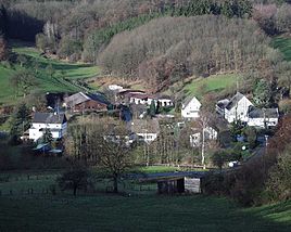
Alpe, 2004
|
||
Alpe in the Oberbergischer Kreis is one of 51 localities in the city of Wiehl in the administrative district of Cologne in North Rhine-Westphalia .
Location and description
The place lies between the places Morkepütz in the north and Oberholzen in the south on the state road L 341 and is about 3 kilometers northeast of the city center of Wiehl as the crow flies. Alpe is located south of the federal motorway 4 .
history
The place was mentioned for the first time in 1553, namely "Tryn in der Ailpenn" in an exchange document called Berg - Sayn . The spelling of the first mention was in the Ailpenn .
The A. Mercator map from 1575 names the place in the Olpen .
In the fodder oat slip of the Homburg rulership of 1580, seven "Bergische subjects" are counted as taxable in the Alpe .
During the turmoil of the Second World War , makeshift quarters were created in a guesthouse for numerous evacuees from the bombed cities on the Rhine and Wupper. Some families then gain a foothold in the Alpe area in the long term.
In the village, one of the rare full-time farms for livestock and dairy farming has been preserved in 2019.
leisure
The following hiking trails, hiking trails and bike paths run through the village:
- the Lenne-Sieg-Weg X11 , a main hiking route of the Sauerland Mountain Association
- the Wiehl local hiking trail O
- the Marienhagener local circular route A3
- the cycle route R20
literature
- Hans Joachim Söhn, Lothar Wirths: Oat feed label. Inhabitants and fireplaces in the Homburg rulership in 1580 (= materials and sources on the Oberberg regional history. H. 3). Galunder, Gummersbach 2003, ISBN 3-89909-012-8 .
Individual evidence
- ^ Klaus Pampus: First documentary naming of Oberbergischer places (= contributions to Oberbergischen history. Sonderbd. 1). Oberbergische Department 1924 eV of the Bergisches Geschichtsverein, Gummersbach 1998, ISBN 3-88265-206-3 .


