Breidenbruch
|
Breidenbuch
City of Wiehl
Coordinates: 50 ° 58 ′ 26 ″ N , 7 ° 32 ′ 25 ″ E
|
||
|---|---|---|
| Height : | 250 m above sea level NN | |
| Postal code : | 51674 | |
| Area code : | 02262 | |
|
Location of Breidenbuch in Wiehl |
||
|
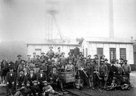
The last crew from the Siegfried mine in 1900
|
||
Breidenbruch is a town in the town of Wiehl in the Oberbergisches Kreis in the administrative district of Cologne in North Rhine-Westphalia . The place is about 5 km north of the city center of Wiehl, as the crow flies, near Bomig . Both break is the north of the federal highway 4 .
history
- In the forage oat lists of 1571 and 1580, a farm owner is listed in the Breidenbroch . It is not known whether the farm was already inhabited.
- In the A. Mercator map of 1575 Im breiden Broich is recorded with the note: a number of hueff ligating together .
- A clearing farm in a protected spring trough location. Places with fragments emerged in the 14th or 15th centuries; the ending indicates a damp, swampy terrain.
- Early mining of iron stone in the area. The last dismantling and exploration work on the Siegfried lead ore mine facing the Halstenbachtal was discontinued around 1900 due to its inability.
- Officially, Breidenbruch has not been an independent place name since 1969, but has been incorporated into Bomig .
literature
- Harald Goering: Breidenbruch. Contribution to the history of a Quellmuldendorf and its surroundings. 2004.
- Alfred Nehls: All wealth lay in the earth. The history of mining in the Oberbergischer Kreis. Gronenberg, Gummersbach 1993, ISBN 3-88265-180-6 .


