Gimborn
|
Gimborn
Municipality Marienheide
Coordinates: 51 ° 3 ′ 38 " N , 7 ° 28 ′ 37" E
|
||
|---|---|---|
| Height : | 250 m above sea level NN | |
| Residents : | 24 (Jun 4, 2008) | |
| Incorporation : | 1st January 1975 | |
| Postal code : | 51709 | |
| Area code : | 02264 | |
|
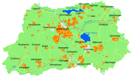
Location of Gimborn in Marienheide |
||
|
Gimborn Castle
|
||
Today, Gimborn is part of the municipality of Marienheide in the Oberbergisches Kreis , administrative district of Cologne , North Rhine-Westphalia and was the seat of government of the imperial rule of the same name for several centuries .
geography
The place is seven kilometers southwest of the community center in a side valley of the Leppe . In the center of the village are the Catholic Church of St. Johann Baptist and Gimborn Castle , the seat of government of an imperial rule that was independent from 1631 and that was raised to a county in 1681 , which was also called " Schwarzenberg Land " after its owners (from 1550) . Today the castle is used by the International Police Association as an educational center.
About two kilometers away (as the crow flies) there are two medieval castle ruins: the Wasserburg Eibach and the Höhenburg Neuenberg .
history
Around 1180 the place was mentioned for the first time as Ginburne in the "Document Book of St. Gereon Abbey"
After the reorganization of Prussia from 1816 to 1825, Gimborn was the chief town of the district of Gimborn , which was then integrated into the new district of Gummersbach .
Until the municipal reorganization in 1975 there was an independent municipality of Gimborn, to which parts of the present-day municipalities of Engelskirchen , Lindlar ( Remshagen and parts of the Leppetals), Gummersbach and Marienheide belonged (cf. §§ 13 Paragraph 2, 14 Paragraph 2 No. 2 , 15 para. 1, 16 no. 3 Cologne Act ). The town hall was located in Hülsenbusch .
Culture
Association
- St. Sebastianus Rifle Brotherhood Gimborn around 1610 eV
Hiking and biking trails
There are the following hiking trails in and around Gimborn:
| Art | Waymarks | Distance | Path length |
|---|---|---|---|
| Circular hiking trail | A1 | Gimborn – northeast Lindlar - Scheel –Lindlar– Oberlichtinghagen –Forsthaus Kümmel – Gimborn | 7 km |
| Circular hiking trail | A2 | Gimborn – Forsthaus Kümmel– Grunewald –Gimborn | 5.4 km |
| Circular hiking trail | A3 | Gimborn - Grunewald - Dürhölzen - north of Jedinghagen - Gimborn | 6.1 km |
| Circular hiking trail | A4 | Gimborn – Grunewald – south of Siemerkusen – Winkel – Hütte – Dürhölzen – Jedinghagen – north of Erlinghagen –Gimborn | 9.5 km |
| Long-distance hiking trail | X9 | Rhein-Ruhr-Weg : Dortmund - Gimborn - Königswinter | 168 km |
| Connection path | <8 | Gimborn - Hintermühle, connection to Schlösserweg X19 | 5.0 km |
Church institutions
The Catholic Church of St. Johannes Baptist Gimborn is part of the Marienheide parish association in the Deanery Gummersbach / Waldbröl. Until the end of 2009 it was the parish church of the parish of Gimborn / Nochen, which was incorporated into the parish of Marienheide in January 2010.
In the tower hall of the church, three memorial plaques commemorate the victims of a catastrophic swimming accident that took place in 1949 in the open-air swimming pool of the nearby dignity .
traffic
The Gimborn bus stop is connected via bus route 308 (Engelskirchen – Lindlar) and 399 (Marienheide – Kotthausen – Holzwipper). The Gimborn station was on the Leppetalbahn , which has been closed .
Sons and daughters of the place
- Adolf von Schwarzenberg (1551–1600), general
- Adam von Schwarzenberg (1583–1641), First Minister of the Brandenburg Elector
Web links
Individual evidence
- ↑ Today's Gimborn Castle was never a moated castle; a moated castle was only the old castle, which lay directly on the Gimbach and was razed at the beginning of the 18th century (see Baudach, Volume 10 of the contributions to the Oberbergischen history).
- ^ Klaus Pampus: First documentary naming of Oberbergischer places (= contributions to Oberbergischen history. Sonderbd. 1). Oberbergische Department 1924 eV of the Bergisches Geschichtsverein, Gummersbach 1998, ISBN 3-88265-206-3 .
- ^ Federal Statistical Office (ed.): Historical municipality directory for the Federal Republic of Germany. Name, border and key number changes in municipalities, counties and administrative districts from May 27, 1970 to December 31, 1982 . W. Kohlhammer, Stuttgart / Mainz 1983, ISBN 3-17-003263-1 , p. 301 .


