Wernscheid
|
Wernscheid
Municipality Marienheide
Coordinates: 51 ° 6 ′ 1 ″ N , 7 ° 33 ′ 33 ″ E
|
||
|---|---|---|
| Height : | 344 (344-370) m | |
| Postal code : | 51709 | |
| Area code : | 02264 | |
|
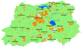
Location of Wernscheid in Marienheide |
||
Wernscheid is a district of the Marienheide community in the Oberbergisches Kreis in North Rhine-Westphalia .
Location and description
The place is in the northeast of Marienheide on the Lingesetalsperre . The Lingesebach flows through the village and flows into the dam south of Wernscheid. Neighboring towns are to be Kierspe belonging place Benninghausen and located in the municipality of Marienheide places Lambach , Linge , Höfel and Kattwinkel .
history
Around 1422 the place was first mentioned under the name "Wernschede" .
hike
The local hiking trail A2 leads through Wernscheid.
bus connections
Wernscheid is connected to local public transport via the Kattwinkel / Wernscheid branch of line 399 (VRS / OVAG).
Individual evidence
- ↑ a b Topographical Information Management TIM-online, provided by the Cologne District Government
- ↑ Wupperverband; River basin geographic information system
- ^ Klaus Pampus: First documentary naming of Oberbergischer places (= contributions to Oberbergischen history. Sonderbd. 1). Oberbergische Department 1924 eV of the Bergisches Geschichtsverein, Gummersbach 1998, ISBN 3-88265-206-3 .
- ↑ Busnetz 2010, Oberbergischer Kreis, published by Verkehrsverbund Rhein-Sieg GmbH

