Gogarten
|
Gogarten
Municipality Marienheide
Coordinates: 51 ° 5 ′ 59 ″ N , 7 ° 30 ′ 9 ″ E
|
||
|---|---|---|
| Height : | 311-340 m | |
| Residents : | 218 (Jan 1, 2008) | |
| Postal code : | 51709 | |
| Area code : | 02269 | |
|
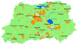
Location of Gogarten in Marienheide |
||
Gogarten is a village in the municipality of Marienheide in the Oberbergisches Kreis , North Rhine-Westphalia , Germany .
Location and description
The place is located about 3.1 km in a south-westerly direction from the main town on the federal road B256 in the valley of the Wipper and the Obergogartener Bach . Gogarten consists of the formerly separated villages Ober- and Niedergogarten . Neighboring places are Krommenohl , Kempershöhe and Sattlershöhe .
history
In 1443 the place was mentioned for the first time in a document in connection with "Income and duties of the Cologne Apostle - Stift "; the spelling of the first mention was Godegarden .
With the expansion of the railway line via Wipperfürth to Marienheide in 1902, Gogarten received a stop on the Wippertal Railway . Freight and passenger traffic ended with the cessation of rail operations on the Wipperfürth Ost and Marienheide section in 1985. A cycle path was laid on the route between Marienheide and Wipperfürth .
From 1995 the place names Ober- and Niedergogarten disappeared from the topographic maps. Instead, the place name "Gogarten" is now used.
leisure
Fairytale forest
Until the 1970s there was a fairytale forest in the village , which was an attraction for families with children in the region. The site consisted of small, fenced-in parcels, on which there were dioramas with fairy tale scenes, the protagonists of which could be set in motion at the push of a button and encouraged to "speak". When the first amusement parks opened in Germany in the 1980s, the fairytale forest had to be closed due to the now strong competition and the resulting unprofitability.
Hiking and biking trails
- SGV district hiking trail 6 ( Wupperweg ) leads past Gogarten from the source to the mouth of the Wupper .
- The interregional cycle route Wasserquintett , a project as part of the Regionale 2010 , runs through the town .
bus connections
Gogarten is connected to local public transport via the local bus stop on line 336 (VRS / OVAG).
Individual evidence
- ↑ Wupperverband; River basin geographic information system
- ↑ a b Historika25, Landesvermessungsamt NRW, sheets 4911, Gummersbach and 4811 Meinerzhagen
- ↑ Topographical Information Management TIM-online, provided by the Cologne District Government
- ^ Klaus Pampus: First documentary naming of Oberbergischer places (= contributions to Oberbergischen history. Sonderbd. 1). Oberbergische Department 1924 eV of the Bergisches Geschichtsverein, Gummersbach 1998, ISBN 3-88265-206-3 .
- ↑ Busnetz 2010, Oberbergischer Kreis, published by Verkehrsverbund Rhein-Sieg GmbH

